
A Geomatics Sector that Spatially Enables a Geospatial Community – A Team Canada Perspective
by Ed Kennedy and Evert Kenk.
Is there value in formalizing definitions for both the Geomatics Sector and Geospatial Community that capture a meaningful relationship between the two? The ongoing Geomatics versus Geospatial debate once again became the focus of spirited discussion on the second day of the recent Canadian Geomatics Community Round Table (CGCRT) ‘Team Canada’ Geomatics Strategy, Action, and Implementation Planning Workshop. At the conclusion of the debate at the Team Canada Event, the majority of participants seemed to agree “geomatics” should remain the word used to describe our sector.
After having been involved in many of the discussions on this topic and supporting the CGCRT Steering Committee in delivering on their first mandate to develop and advance a Pan-Canadian Geomatics Strategy, we think there is value!
In November 2013 the CGCRT Steering Committee held a workshop to develop a first draft of the Pan-Canadian Geomatics Strategy. As the workshop progressed the terms Geomatics, Geospatial, Sector and Community were being used almost interchangeably, which was creating confusion. This discussion culminated in the decision to develop more specific meanings for these terms.
The Pan-Canadian Geomatics Strategy defines the Geomatics Sector as organizations, associations and individuals involved in the provision of data and information products, technologies, services, and expertise involving: geospatial information capture and processing; geospatial information analysis and presentation; integrated information products and services; and location-based solutions. It includes those companies and government agencies providing the geodetic framework, core data and core location based services enabling analysis in terms of, or the use of anything in the context of, location on, over or under the earth’s surface. It encompasses the disciplines of surveying, hydrography, mapping, remote sensing (often called earth observation) and geographic information processing (often called GIS). There is evidence that the term is gaining popularity. For example, in 2001 only 8% of ‘geomatics’ firms in the Industry Canada Canadian Company Capabilities database mentioned the word geomatics in their descriptions. Today, that number has increased to 21%.
For the purposes of the Strategy, Geospatial Community is defined as the broader community encompassing the Geomatics Sector plus the organizations and individuals that use the data and information products, technologies, services and expertise provided by the Geomatics Sector. As the use of geospatial information becomes increasingly embedded in the day-to-day work of a growing group of users, the Geospatial Community will continue to expand.
Core data has also been defined for the purposes of the Pan-Canadian Geomatics Strategy as data that conforms to specific CGDI data components: Foundation, Framework, a necessary subset of Thematic data sets and all associated metadata. Foundation layers include geometric controls required to position geospatial information adequately. These layers are critical to the reliability and use of all other layers. Framework layers include Land Feature/Form layers that contain well-defined and readily observable natural or manmade physical features, such as roads, rivers and elevation. Thematic layers contain information that society develops and uses to describe and administer the country, and include features such as municipal boundaries, federal electoral districts, and ecological areas. It is understood that core data content needs to adapt to the changing needs of the Geospatial Community and the results of innovation and research. Core data is generally expected to be accurate, authoritative and accessible (AAA) and to be provided by governments.
The Geomatics Sector is also responsible for the development and delivery of Canada’s network of spatial data infrastructure (SDIs) to provide users with necessary core data services. Canada’s SDIs deliver on the “accessible” component of AAA core data, by making conveniently available a set of geographic information, such as address, postal codes, roads, cadastre, and census data, including related metadata, which is necessary for enabling geographic applications and service delivery.
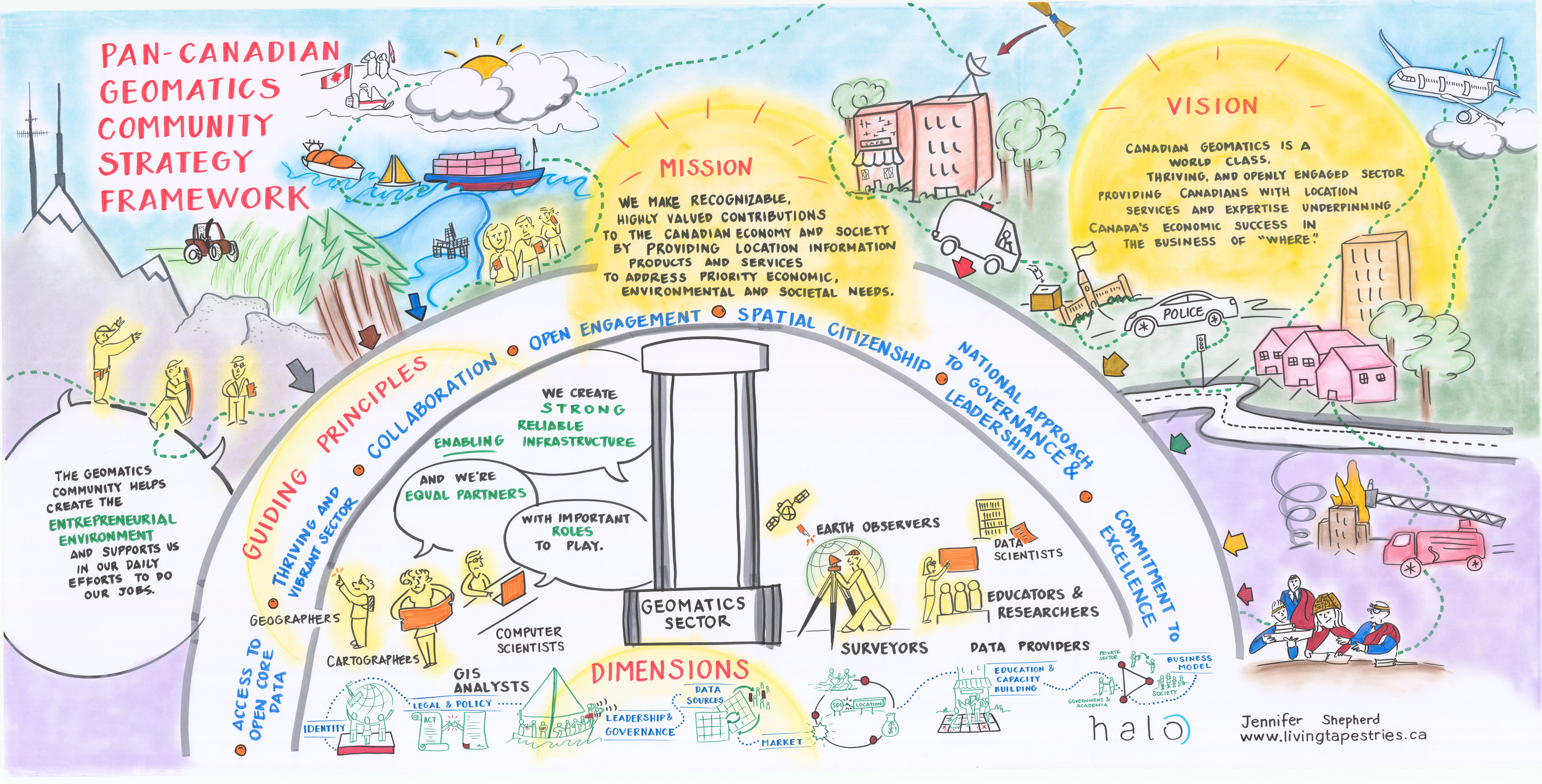
During that November 2013 CGCRT Steering Committee workshop a visual “tapestry” was created capturing the conversation that was taking place. This tapestry, which is included in the Strategy, captures the outcome of the discussion showing the role of the Geomatics Sector as spatially enabling the much broader Geospatial Community of which it is a part. As captured in the tapestry, the Geomatics Sector includes those specialists providing the core data, geospatial products and location-based services needed by the broader Geospatial Community, such as foresters, geologists, health care specialists and emergency responders, to do their jobs. Beyond this circle is illustrated the broader public that is becoming geospatially-enabled through use of these services but is not generally cognisant of the Sector.
We hope that you can picture yourself within the visual representation of the Geomatics Sector and Geospatial Community in the tapestry, and encourage you to make use of it and the ideas presented in the Strategy to help explain to others what you do and the role of the Geomatics Sector in geospatially enabling the world we live in.
This article was originally published on cgcrt.ca
Ed Kennedy is a Senior Associate with Hickling Arthurs Low (HAL) Corporation and Principal at Kennedy Geoinfo Consulting. From 2003-2011 he was Managing Director of Canadian GeoProject Centre, a business network hub that helped to source spatial information projects in target foreign markets. Mr. Kennedy’s previous positions included President of the Geomatics Industry Association of Canada (GIAC), and Assistant Deputy Minister with Alberta Forestry, Lands and Wildlife. Ed’s experience with research, consultation, technology evaluation and analysis, workshop leadership, and strategy development spans the past 25 years. He holds an undergraduate degree in Engineering and a Masters degree in Business Administration.
Evert Kenk is currently a private consultant to natural resource sector clients. He is retired from the British Columbia Provincial Government as its Chief Resource Information Officer for the Natural Resource Sector, and as Executive Director of GeoBC, where he was responsible for delivering corporate shared information services to natural resource sector ministries and their business and public clients.


Great job ! This is in sync with the original and intended definition of “geomatics” in the late 1970s-early 1980s that still prevails today (and the fundamental reasons for creating this term) while it clarifies the link with the broader geospatial community who don’t identify themselves as geomaticians or geomatics engineers. The explicit identification of this subgroup-group relationship is useful and meaningful, it highlights the fact that geomatics has become ubiquitous in our Society.
“There is evidence that the term is gaining popularity” is encouraging for the Sector, although we all know that is has already been widely popular and recognized in Quebec (where the word originated with its modern definition).
This canadian perspective corresponds well with undergraduate curricula at universities and colleges where there are geomatics programs to feed the Sector with qualified personnel, geography programs to feed mostly the geospatial community (although a few offers specializations to contribute to the geomatics sector), and all other professional sectors which feed the geospatial community.