|Waldseemuller's Universalis Cosmographia")
As much a science as an art; cartography makes one wonder how the artist or mathematician-cum-geographer captured the most finite of cartographic details.
Ancient maps are fascinating and inspiring. In this article I will discuss a number of interesting examples of cartography through a collection of ancient and historic maps.
- Claudius Ptolemy’s Geography (150 AD)
The Ptolemy world map is known worldwide and is based on the book named Geography written by Claudius Ptolemy in the 150th century. By close inspection one can see the lines of longitudinal and latitudinal. The Ptolemy map identifies earthly locations by heavenly observations. In this map we can see the continents of Europe, Asia and Libya or Africa. The noticeable ocean is only portrayed in the west side of this map. Two main seas are illustrated: the Mediterranean and the Indian.
Ptolemy World Map
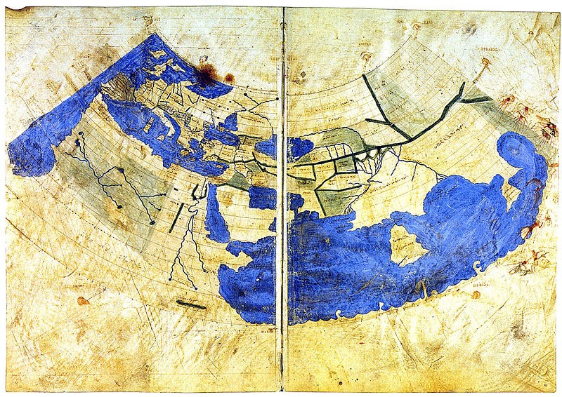
Even though the circumference is not precise, this exquisite map captures the growth of the Roman Empire towards the East. Historians speak of significant Indian exports of spices, silks and food by the Rome during the 2nd century. Later through the years the Romans moved further east and traded on the steps of China
One key aspect of the Ptolemy map is the colour blue within the contrast of what is now the pale beige colour of the land. The brilliant blue brings the spectator in closer to see the richness of the lines used to separate the countries. This charismatic map was ahead of its time and set the stage for subsequent maps.
- The Hereford Mappa Mundi (1300 / 1285)
This map was discovered underneath the floor of an English Cathedral on preserved calfskin, measuring five feet high by four feet across. The Hereford map is captivating with medieval drawings of biblical events, exotic plants and animals, wild and peculiar creatures from classical myths. This extraordinary artifact is one of the largest maps from the Middle Ages.
Mappa Mundi
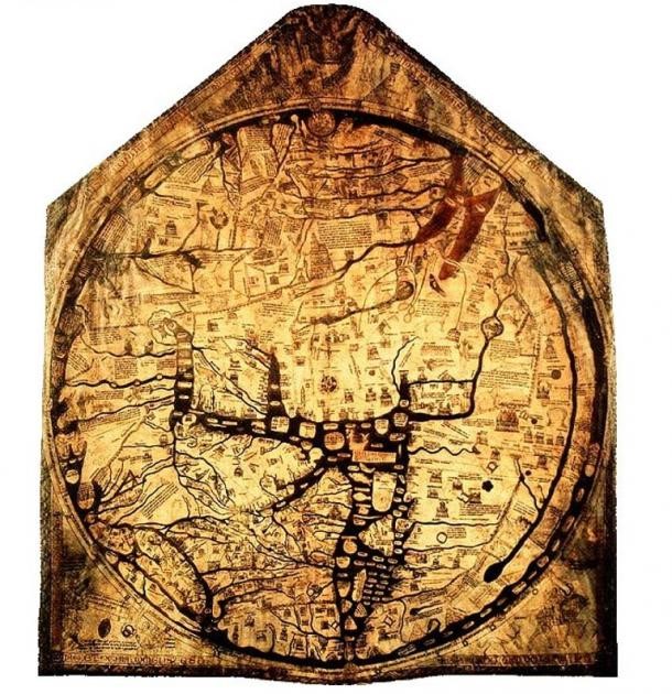
It is important to note that this map wasn’t used as a navigation tool, but functioned more as a tool to discuss current and past conundrums, stories and the world in general.
The brilliance of the Mappa Mundi cartography is linked with the relationship of Christ because the east direction is found at the top due to the rising of the sun bearing and the second coming of Christ.
The main continents covered are Europe, Asia and Africa and there are around 420 towns and cities, such as Rome or Roma and Paris which are clearly shown.
In relation to myths and legends there are 8 classical legends beautifully articulated:
- Jason and the Argonauts search for the Golden Fleece is shown in the drawing on the coast of the Black Sea.
- The Cretan Labyrinth is portrayed on the vellum.
- The Columns of Hercules represented the western edge of the known colonized world.
- The camp of Alexander the Great is illustrated.
There are 15 bible stories are depicted on the Mappa Mundi, including:
- The Garden of Eden, with Adam, a serpent, and Eve, all located towards the top end of the map. The Garden of Eden is encircled by a ring of fire, illustrating this regal garden is no longer for humanity.
- A boat filled with animals and a bearded man symbolizes Noah’s Ark.
There is a large building on the map which relates to the five-story city of Babylon, known as the “Tower of Babel.”
- Henricus Martellus World Map (c1490/1491)
Henricuc Martellus Germanus was a German geographer and cartographer, he settled in Florence, Italy from 1480 to 1496. It was during his time in the romantic city of Florence that he created his world map. Ptolemy gave some inspiration to this map because of the similarity in the effervescent blue colour throughout the Earth’s surface. The striking portrayal of the African continent suggests information was provided by African sources.
The map measures 201cm by 122cm and it has been noted by scholars that Christopher Columbus studied this map in detail before he set sail on his voyages of discovery.
Martellus World Map

Experts believe that this map dates about 1491. Martellus’s map provides us with an impressive interpretation of the Atlantic Ocean in the West and Japan to the east. There are descriptions in Latin in relation to numerous regions and peoples. The Latin inscribed over northern Asia roughly means: the people of “Balor” that eat deer meat and survive without wine or wheat.
There are other inscriptions on this map. A text box within the Indian Ocean speaks of “a sea monster that is like the sun when it shines”.
- Waldseemuller’s Universalis Cosmographia (1507)
The German cartographer Martin Waldseemüller printed his wall map in 1507. This was the first map to recognize America and to illustrate the America continent as two parts. We can clearly see South America on the map. Waldseemüller’s map identified the Americas with the knowledge received from the voyages by Amerigo Vespucci and Christopher Columbus.
Universalis Cosmographia
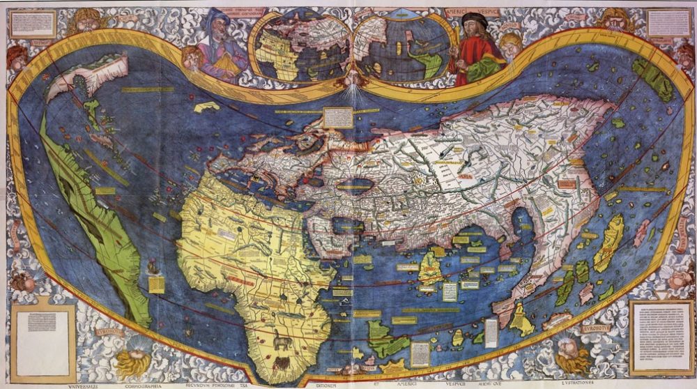
There are many fascinating aspects to this map. The actual title of this map in Latin is: Universalis cosmographia secundum Ptholomaei traditionem et Americi Vespucii aliorumque lustrationes. This translates into The Universal Cosmography according to the Tradition of Ptolemy and the Discoveries of Amerigo Vespucci and others.
The map measures 18 by 24.5 inches (46cm x 62cm). There are 12 sections printed from woodcuts. This map used the rounded meridians projection to portray the complete area of the Earth. On close observation within the upper-middle part of the map a smaller world map is noticeable.
- Ribeiro’s World Map (1529)
Diogo Ribeiro was a Portuguese mapmaker in the early 16th century. During this period Spain and Portugal were adversaries vying to dominate the Moluccas islands spice trade. Diogo worked for the Spanish to producing his map based on a purely scientific method. Ribeiro’s map defines the coasts of central and South America. The entire east coast of the Americas is presented and the west coast shows the region from Ecuador to Guatemala. There is no recognition of Australia and Antarctica because these lands had not yet been discovered by Europeans. The Indian subcontinent and the Pacific Ocean are shown.
Diogo Ribeiro’s Map

These are just a few of the most astonishing maps throughout the ages. The above named cartographers followed their passion when it came to gathering information and then creatively forming detailed drawings of the lay of the land.
All mapmakers require a diverse set of skills. They need to be able to interact with travelers, checking their work for accuracy, conscripting, exploration, investigation, and preservation. Many of the above named mapmakers could speak 3 to 4 languages fluently.
So what are your favorite maps of all time? Be sure to make a comment below on your favorite map or maps of the past centuries.
Be the first to comment