
Canadian Geospatial Briefing for January 18th: Scientists flag hotspots for protection; MNR releases solar potential tool; Transport Canada invests in its Aerial Surveillance Program; MDA is GeoIgnite Platinum Sponsor; CSA releases its first AO; NV5 Geospatial gains momentum in Canada
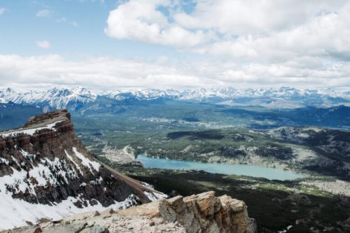
Scientists flag Rocky Mountains, Hudson Bay as hotspots for protection
In 2017 an expert team was put together to advise the Canadian government on ways to meet its conservation targets. They were tasked with identifying areas that provide important ecosystem services but the information didn’t exist. So the team worked to create the maps and data they needed to determine areas throughout Canada that provide important ecosystem services — such as landscape-based carbon storage, flood prevention, fresh water and food resources and outdoor recreation — so they could be taken into account when deciding where to put new protected areas.
Canada has committed to protecting 17 per cent of the country’s land and fresh water by the end of 2020 — a target that has expanded to 25 per cent by 2025 and 30 per cent by 2030. The maps the team created has identified several areas that are important hotspots for ecosystem services that are not currently protected. The eastern slopes of the Rocky Mountains in Alberta, for example, are one of the most important places in the entire country for fresh water, providing water to people across the Prairies from Alberta to Manitoba, while also being a major hotspot for nature-based recreation.
Other important hotspots identified include the north shore of Lake Superior for fresh water and recreation and the massive carbon storage hotspot of the Hudson Bay lowlands, which outstrips all other carbon sinks in Canada and is at risk from road building and proposed mining projects. A group of Indigenous Peoples is working to protect an undeveloped part of this area in northern Manitoba by preserving the Seal River watershed as an Indigenous Protected Area.
https://thenarwhal.ca/canada-protected-areas-conservation-maps-2021/
This open source tool maps Canada’s solar potential
Canada’s Ministry of Natural Resources has launched an open-source web-mapping application that provides estimates of photovoltaic potential and daily global insolation rates for any location in Canada. The tool also allows users to collect data on single municipalities from a dataset of 3,500 places.
The maps were designed by the Canadian Forest Service, the CanmetENERGY Renewable Energy Integration group, and the Federal Geospatial Platform and they also include data provided by Environment and Climate Change Canada.
https://pv-magazine-usa.com/2020/12/22/this-open-source-tool-maps-canadas-solar-potential/
Contract awarded to acquire a remotely piloted aircraft system for Transport Canada
Government of Canada has awarded a $36.16‑million contract to Elbit Systems Ltd. for the acquisition of a remotely piloted aircraft system (RPAS) or drone. Transport Canada requires this drone to effectively continue delivering its National Aerial Surveillance Program. This program works to help keep Canadian waters safe and to monitor pollution.
MDA Platinum Sponsor of Canada’s National Geospatial Event: GeoIgnite 2021

GeoIgnite is pleased to announce that MDA is supporting the Canadian Geospatial community as our Platinum sponsor for 2021!
This year’s event will consist of three great events in April, bringing government and industry together for innovative programming.
Interested in sponsoring GeoIgnite 2021? Learn more: https://gogeomatics.ca/mda-platinum-sponsor-of-canadas-national-geospatial-event-geoignite-2021/
Canadian Space Agency releases smartEarth downstream satellite data opportunity
The Canadian Space Agency (CSA) has released its first announcement of opportunity (AO) of the year, this one related to its smartEarth program for the creation of applications to harness satellite data.
The AO is titled Canadian Downstream Space Sector Delivering on Canada’s Better Future and has a $8 million in funding with selected projects receiving between $150k – $500k. The CSA says it will select 20-30 projects. Projects have until March 5, 2021 to submit their applications with an estimated project start date of this October. The projects are expected to be completed within 24-36 months from their start.
https://spaceq.ca/canadian-space-agency-releases-smartearth-downstream-satellite-data-opportunity/
NV5 Geospatial gains momentum in Canada with series of topobathymetric LiDAR and aerial imagery wins in 2020
NV5 Geospatial has expanded its Canadian operations in 2020. Most recently, NV5 Geospatial won and began acquiring data for the largest riverine topobathymetric LiDAR project, spanning over 900 linear kilometers of 28 principal watercourses for the Montréal Metropolitan Community.
The topobathymetric LiDAR survey in Montreal is just one of the several projects NV5 Geospatial has undertaken during the past year. They have also been selected as an approved supplier for the Canadian Hydrographic Service, Natural Resources Canada, the Province of British Columbia (GeoBC), and the City of Ottawa
NV5 has already conducted work for a number of Canadian clients, including Elexicon Energy in Ajax, Ontario. NV5 also worked with GeoBC to better understand the potential impact of a tsunami or major flooding event on Vancouver Island.
NV5 Geospatial is part of North America’s largest geospatial data firm, Quantum Spatial.


