Countdown to Launch: DigitalGlobe’s WorldView-4 Earth Imaging Satellite
Final preparations are underway at Lockheed Martin to ship DigitalGlobe’s WorldView-4 earth imaging satellite to Vandenberg Air Force Base for a Sept. 15 launch.
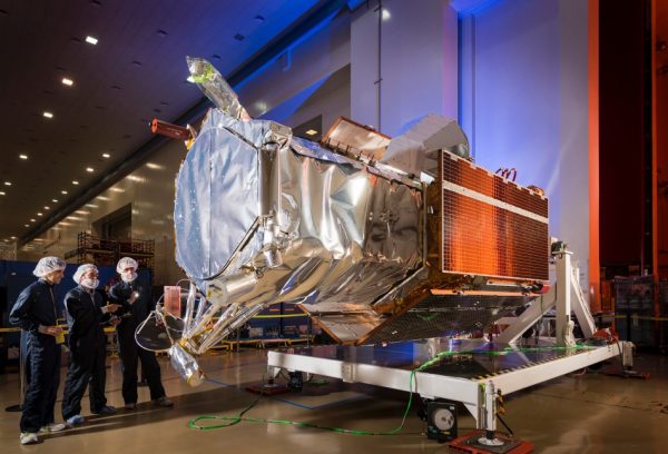
The Lockheed Martin team is completing final satellite testing and checkout before shipment. Testing includes calculating the weight and center of gravity of WorldView-4, completing a health check of major systems, and testing out image collection and downlinking capability.
“The high resolution and high accuracy images taken by WorldView-4 will support DigitalGlobe’s worldwide customer base,” said Carl Marchetto, vice president and general manager of Lockheed Martin Commercial Space. “DigitalGlobe’s smart imagery serves hundreds of thousands of end-users charged with the safety and security of nations, and enables the maps and geospatial applications relied on by billions of consumers.”
“Only the DigitalGlobe constellation, with the addition of WorldView-4, offers the highest quality, and most comprehensive global coverage of our changing planet through 2030, so our customers can be confident they will have the information to make critical decisions,” said Dr. Walter Scott, Founder and Chief Technology Officer, DigitalGlobe. “WorldView-4 will help us continue to transform the way we see the world, and advance our mission of keeping our planet and its people safe and secure.”
Once launched, WorldView-4 will double DigitalGlobe’s coverage of the world’s highest resolution imagery and increase the rate at which it grows its 15-year library of time-lapse high-resolution imagery. WorldView-4 will orbit Earth every 90 minutes, traveling 17,000 miles per hour and capturing more 680,000 square kilometers of the Earth’s surface daily (19.5 terabytes) the equivalent of the land area of Texas.
With an orbit approximately 400 miles from Earth, the satellite will be launched aboard a United Launch Alliance (ULA) Atlas V rocket provided by Lockheed Martin Commercial Launch Services.
About Lockheed Martin
Headquartered in Bethesda, Maryland, Lockheed Martin is a global security and aerospace company that – with the addition of Sikorsky – employs approximately 126,000 people worldwide and is principally engaged in the research, design, development, manufacture, integration and sustainment of advanced technology systems, products and services.
About DigitalGlobe
DigitalGlobe is a leading provider of commercial high-resolution earth observation and advanced geospatial solutions that help decision makers better understand our changing planet in order to save lives, resources and time. Sourced from the world’s leading constellation, our imagery solutions deliver unmatched coverage and capacity to meet our customers’ most demanding mission requirements. Each day customers in defense and intelligence, public safety, civil agencies, map making and analysis, environmental monitoring, oil and gas exploration, infrastructure management, navigation technology, and providers of location-based services depend on DigitalGlobe data, information, technology and expertise to gain actionable insight.