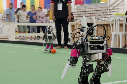
Geo Soon: Coaching Robots
Continuous surveying, to support smart cities, infrastructure, geodesign, and construction, is opening expanded—but unconventional—roles for surveyors and geospatial practitioners.
“Put me in coach, I’m ready to play… today…” – John Fogerty
[The following guest op-ed first appeared in xyHt Magazine’s Outlook 2019 issue]. The days of a bipedal survey-rod-carrying robot member of your field crew may be a distant future, but the work of field data collection has already been impacted by robotics, namely in the form of process automation. This will only increase as AEC industries and geospatial professions rise to meet the pronounced global uptick in demand for infrastructure development and modernization. This represents a lot of opportunities to grow the disciplines and professions, but not in the ways we are accustomed to.
Throughout 2018, I’ve had opportunities to interview leadership in the geospatial and AEC industries, and listen to their keynotes at conferences—and a theme that falls into the geo-sooner-than-we-think category is emerging. One key message from each is much the same: the demand for new, updated, smarter, and greener infrastructure cannot be met with legacy tools and methods. Period. World population growth—without corresponding growth in funding and resources—means we need to work smarter and improve engineering and construction efficiencies. It is not simply a matter of throwing more people at the problem (though there could need to be more skilled people needed to support increased project portfolios); we need practitioners that can work more harmoniously with the “bots”: automated elements, reality capture technologies, and integrated project management delivery systems. We’re not just talking about the mechatronic tools, like robotic total stations, autonomous UAS, mobile mapping, scanners, and imaging systems. Automation in data analysis, automated feature extraction, applying machine learning and AI—these have steadily made inroads into our workflows, both subtly and dramatically.
Continuous Surveying
For BIM to work throughout a design, construction, and operational cycle needs that reality capture, accurately and frequently; often so frequent as to demand the use of not only automated field data collection, but new levels of feature extraction and model updates. Smart construction, like smart manufacturing, needs a constant feedback loop. The vision of geodesign, the seamless melding of design detail (e.g. IFC BIM models, Revit models, iModels, etc) in the broader context of geospatial data (GIS) is reaching fruition. For example, in the developments sparked by the Esri-Autodesk partnership.
“Continuous representation of reality” is a term that Topcon Positioning Systems CEO Ray O’Connor has described for many years as an all-important element of a successful modernization of the construction industry. What the manufacturing sector has been able to do in automation and modernization for many decades is a holy grail sought for construction, an industry still beset by legacy inefficiencies. A joint effort between Topcon and Bentley Systems to promote “constructioneering”, a way to remove some of the barriers between the design, survey, and construction processes, promotes a new wave of automation, workflow, and data integration. The collaboration between Autodesk and Leica Geosystems on the reality capture software and operation elements of the BLK360 scanning system demonstrates another element of this “bot” future: making the act of data capture simpler, more automated, and getting solutions into the hands of more users. In fact, one of xyHt’s 2019 40 under 40 honorees, roboticist Aaron Morris (who was a lead on that team) has now launched a new firm focused specifically on feature and analytics extraction from this new tidal wave of reality data being generated by these bots and semi-bots.
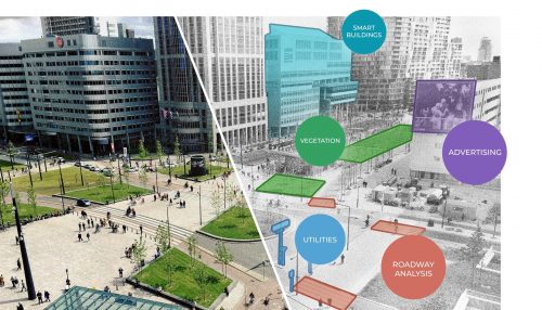
Smart cities, smart infrastructure, promise better management and analyses, but will require more frequent and detailed surveying and mapping – image source Allvision IO
The advent of “continuous surveying” is already upon us. The term is gaining broad acceptance in the AEC and geospatial industries, casually referred to in keynote speeches and project presentations at international industry conferences. An excellent summation of the concept is by Durk Haarsma of GIM International (October 2016). The work of developing tools and methods for continuous surveying has accelerated. The 2019 40 Under 40 list of Outstanding Geospatial Professionals includes profiles of brilliant engineers and scientists working on these solutions. Like Spencer Disque of Sigma Space, working on single photon lidar, Jackie Chow who works in sensor integration, camera calibration, and robotic vision. There is Yan Fu, a principal scientist with Autodesk working on 3D mesh and other reality modelling technologies.
Coaching and Conducting
Talk of automation understandably raises concerns—Ok, in some cases panic—about job and career security. There is no sugar coating of the fact that automation impacts jobs, sees the nature of professions change and can force career changes (or the need to change substantial elements of thereof). When faced with what seems to be a relentless paradigm of change, we ask, what is wrong with simply using our current skills, tools and methods? And if there is an increase in demand why can’t we can just train more practitioners? That would surely grow our professions. I could choose to hang on to the past: I am quite certain that I could still take on boundary survey work using the analog instruments on my mantle, or even topo small sites for design and construction projects. But our clients and customers are not as nostalgic as we are, and the scale and complexity of such growing demands will not be sustainable if we do maintain the status quo. Through automation there may be a reduction in hours spent in the mechanical elements of our jobs, but this can free up more people and time for QA/QC, process management, and analysis. If we are no so occupied with the mundane, we are freer to pursue the profound.
There are some elements that will not change: the professional judgement, experience and skill evaluating, for instance, boundary evidence, or alternatives analysis to best meet customer desires and needs. There are no magic AI solutions for those elements. Yes, you can do the measurement and processing elements of your work with legacy and current tools. But the very nature of your work that may soon change. Practitioners will be called upon to be become much more productive—requiring new skills and perhaps a new “digital crew”.
These “bots” are fast learning how to recognize patterns in data as they map and process more and more corridors, and through machine learning, raising certainty and reliability in feature recognition and sit analyses—but they need a coach, a conductor. One prediction I mention to surveyors at conferences is that the near-future total station will do a preliminary scan/image/ranging cycle—before the surveyor even looks through the scope—that recognizes many features and generates a rough 3D model. And from that point the surveyor fills in the critical features the bot misses. I get a mix of responses ranging from “cool!”, to “no way, no never”, and “it can’t hunt for and dig up a corner” (very true). And when I pitch the scenario of the “totally” station to some of the hardware developers at some of the manufacturers, the response is kind of a smile and wink. Such development is undoubtedly under way.
We are not powerless ahead of some bot takeover of geomatics and geospatial, but we may need to consider more of a “coach or “conductor” role. There are critical steps of planning, deployment, scheduling, specifying what each potential bot and bot-function needs to do, the expectations and quality control, these are human elements. The future will hold a lot of opportunity for the skilled and savvy surveyor or geospatial practitioner that leads their human, and digital teams forward.