GeoIgnite 2020 Tracks, Summits, and Forums Announced

I’m thrilled to announce our first tracks, forums and summits for GeoIgnite 2020. A big thank our GeoIgnite conference committee for all the hard work putting our program together. GeoIgnite is an exciting addition the Canadian geospatial community conference circuit.
GeoIgnite 2020 will bring together senior members of the government, business executives, and thought leaders in the IT and location technology sectors in our nation’s capital. GeoIgnite 2020 will grow into Canada’s largest geospatial event with over 1,000 participants over the next 5 years and is already unique as Canada’s annual geospatial leadership conference.
If you are interested in submitting a proposal for a track related talk, please email our track chairs directly.
Defence and Security Day

Track Chair: Anthony Mayne
GeoIgnite is pleased to announce its new tract dedicated to the men and women that strive to protect Canadians at home and abroad. Our new Defense and Security day will gather leaders and key figures in the Department of National Defense, Police Forces both provincial and federal, and other government organizations involved with public safety.
Geospatial Commercialization Track
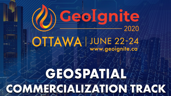
Track Chair: David Gachuche
Canada has led the world in the commercialization of location based technologies like remote sensing and GIS. This year at GeoIgnite, we will showcase transformative technologies from industry as we explore the diversitification of geospatial markets in area like insurance, space, defence, infrastructure mapping, smart cities, agriculture, energy, oil and gas, and investment banking.
Mapping the Underground

Track Chair: Geoff Zeiss
The summit is targeted on professionals for whom underground utilities represent a risk or an opportunity; surveyors, subsurface utility engineering and locate specialists, utility regulators, federal, provincial, local government and utility policy makers, utility associations, geomatics professionals, academics in geomatics and geography, smart city specialists.
Remote Sensing Track: Big Data Geospatial Imagery – Next Level Technology, Platforms, Access, Algorithms, Standards & Skills

Track Chair: James Ashton and John Roos
Join Canada’s best and brightest as they come together at GeoIgnite 22020 for our remote sensing track. Future of innovations in remote sensing, geomatics and imagery will depend on translating big data into information and knowledge and navigating new cloud based platforms and cloud native processes required to conduct predictive analytics and monitoring of occurrences on the land. Canada has many active scientists working on the phonological aspects of disease, harvest detection, drought, flood, soil moisture, detection, emergency response, however there is considerably less investment in aspects navigating an agile cloud implementations that scale to the cloud and harmonizes these data science activities in the public cloud offering.
Finding the Right Balance: Geospatial technologies, Data, Policy and Privacy

Track Chair: Amina Deiab
GeoIgnite is please to present our Canadian policy and geospatial issues discussion track. The evolution and proliferation of geospatial technologies and the increasing usage of geographic information systems has created an exponential growth of geospatial data, and with it, new market and business opportunities. Geo-spatial data and data analytics play a crucial role in economic development with the global geospatial data analytics market foretasted to grow from $69.9 billion in 2018 to $88.3 billion in 2020. However, the increased usage of geographic information systems, geospatial technologies and the individuated characteristics of location data has brought with it an increase in public concern over consumer privacy.
Canadian Geospatial Cities Forum: Canadian Smart Communities, Opportunity and Challenge in the Next Decade

Track Chair: Prashant Shukle
This track will span the idea of smart cities/municipalities from a policy/complexity thinking perspective; cyber security perspective; emergency management; sustainability (finance, infrastructure, environmental perspective) and open cities versus proprietary cities.
The Impact of OGC Standards on Society
“It was the best of times, it was the worst of times”

Track Chair: Nadine Alameh
Co-organized by The OGC Canada Forum and Natural Resources Canada, the session will focus on selected community activities and the impact of standards on real-world challenges in Canada and around the world.
Geospatial Reference Systems are Changing in the United States: How will Canada Respond? How Will you be Affected?

Track Chair: Calvin Klatt
We are excited to announce Canada’s Surveyor General will join us from NRCan for GeoIgnite. Join NRCan and stakeholders for a discussion and exploration on this important change in the geomatics landscape in North America.
Once the United States adopts NATRF2022, a horizontal coordinate difference of 1.3 to 1.5 m will exist at the Canada-U.S. boundary. Canada must decide how to respond to these same changes.
Diversity + Inclusion = Better Decisions

Track Chair: Bilyana Anicic
The GeoIgnite Conference and our sponsors are proud to present the second Diversity Leadership Summit. Our inaugural Summit was a great success featuring relevant diversity and inclusion topics, a powerful panel of speakers, and a “full house” of engaged participants.
This conference is focused on providing attendees with updates on technology, data, services, and thought leadership. GeoIgnite will bring the latest innovations and the next generation of disruptive geospatial technologies under one roof for three days of connection and collaboration.
I hope that you can join us. Our exhibition is filling up and our first sponsors have come on board. Please check us out at www.geoignite.ca
Get your early bird ticket soon!
THANK YOU TO OUR GOLD AND SILVER SPONSORS