Geomagnetic field is a reliable tool for navigation and mapping applications
Our Earth is surrounded by its magnetic field that extends from the planet’s core to the outer space. It is formed by electric currents which are generated by the movement of molten iron and nickel under the crust. The variation of geomagnetic intensity across different locations can be used to determine our orientation and location.
Different north, different orientations
In general, there are three versions of the north that we can find on different maps, including geographic (true) north, grid north and magnetic north. The Earth’s true north is always pointing to the geographic North Pole. The position of the true north is the same as the location of its rotation axis. Grid north is used to define orientation alone the grid lines that are shown on a large-scale local map. Grid north is generally referring to the top of that map, which is always presented with the form of a flat earth.
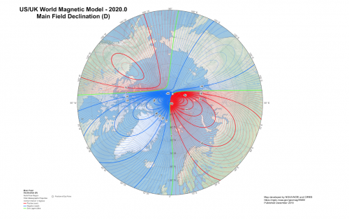
The magnetic north is always pointing to the magnetic pole where the geomagnetic field is vertical [1]. It is the intersection of the Earth’s surface and the axis of a bar magnet. The magnetic north pole moves at a rate of around 56 kilometres per year, therefore magnetic declination should be calculated regularly to update the direction of the magnetic north [2].


The rotation axis of the Earth does not shift, while the magnetic axis is slowly moving.
Photo courtesy: Left: Pesquisa FAPESP. Right: Natural Resources Canada.
Geomagnetic model can assist GNSS for positioning and navigation
Although GNSS is a popular choice for positioning and navigation, it is vulnerable to jamming and spoofing. The US air force is trying to develop a new magnetic anomaly navigation technique as a reliable alternative [3]. The authority believes that unique geomagnetic details can be used as “landmarks” for users to determine their relative position, especially when travelling over the oceans or deserts without any topographic features.
In Canada, the Magnetic Anomaly Map of Canada is created by Natural Resources Canada to visualize the geomagnetic field in (at the) regional level, by referencing the Canadian Geomagnetic Reference Field. The variation of the magnetic field can be used to detect the alteration of bedrock structures and distribution of underground mineral concentrations.
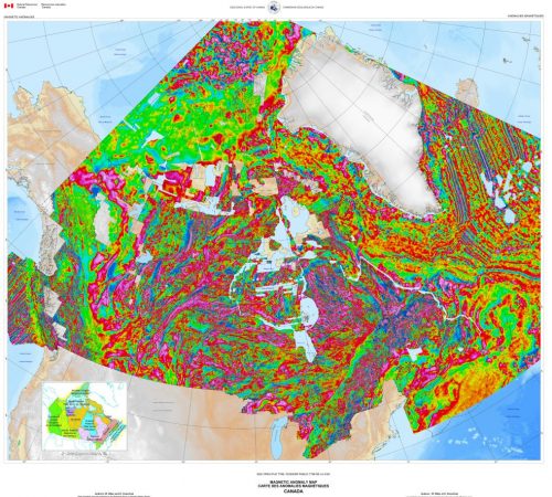
The latest model of the Canadian magnetic anomaly map.
Photo courtesy: Natural Resources Canada.
Different types of data acquisition method
Magnetic Observatories (for monitoring)
The Geological Survey of Canada is operating 14 magnetic observatories across the country. These magnetic survey stations are built on locations with long term stable environments in order to determine the magnetic field in absolute terms [4]. Alike traditional land surveys with a total station or laser scanner, magnetometer surveys require base stations as a reference to adjust magnetic fluctuations [5].
Shipborne magnetic survey
Marine magnetic survey is mainly used to study the ocean floor and tectonic plate movements. For example, several practices were performed to explore the seabed of Hudson Bay and the coastal area of the Atlantic Provinces in the 1970s [6][7]. It is always conducted with an airborne magnetic survey together to cover the coastal area and the adjacent continental shelf areas.
Airborne magnetic survey
Alike shipborne magnetic survey, airborne magnetic survey had a long history in Canada. The Geological Survey of Canada began the aeromagnetic survey practice since 1946, which later became an ongoing national program [8].
Applications of aeromagnetic survey
Geophysical surveying companies are regularly working with academic institutions, government sectors and mining companies to generate geomagnetic maps for specific uses. Sander Geophysics Limited is specialized in magnetic, radiometric and gravity surveys. They are working on a research project to improve the existing magnetic navigation system. The researchers are developing a machine learning approach to solve the magnetic interference caused by the aircraft itself [9].
Terraquest Ltd. is another mapping service company from Toronto which is also specializing in airborne geophysical surveys. The company has completed a helicopter magnetic survey recently at Lundmark-Akow Lake and North Caribou River in northwestern Ontario. Map products were prepared to explore the location of gold mineralization [10].
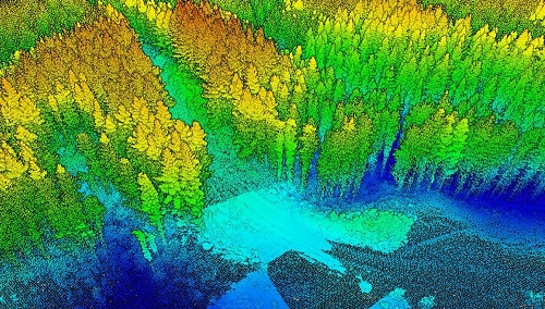
Moreover, a geomagnetic survey can be finished by unmanned airborne vehicles with improvements in efficiency, size, flying range and payload. It is also an innocuous alternative when compared with fixed-wing aircraft or helicopters. GEM System offers a mature drone magnetic survey solution with a flying height as low as 100 feet to ensure a stronger signal, higher resolution and less noise [11].


Aerial magnetic survey is a efficient and effective solution to scan large subject sites.
Photo courtesy: Left: GEM System. Right: Colin Bowdidge.
Further Reading
[1] http://wdc.kugi.kyoto-u.ac.jp/poles/polesexp.html
[2] https://geomag.nrcan.gc.ca/mag_fld/magdec-en.php
[3] https://www.gpsworld.com/us-air-force-to-explore-navigating-with-magnetism/
[4] https://www.geomag.nrcan.gc.ca/obs/default-en.php
[5] https://www.gemsys.ca/stationary/
[6] https://link.springer.com/article/10.1007/BF00305565
[7] http://archives.datapages.com/data/cspg_sp/data/004/004001/891_cspgsp0040891a.htm
[8] http://www.science.gc.ca/eic/site/063.nsf/eng/97256.html