


Geomatics Tools In The Protection and Conservation of North American Right Whales
Right Whale Biology + Conservation
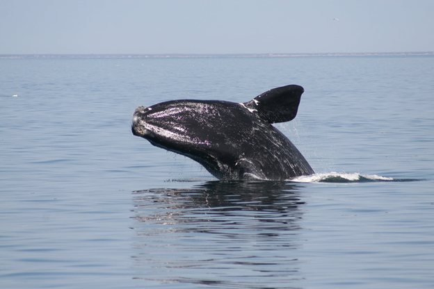
When speaking about declining populations in species, the words endangered, vulnerable and threatened often come to the forefront but for most people, those are vague and encompassing words that do not portray a lot of urgency. In the case of the Critically Endangered North American Right Whale, this equates to fewer than 400 individuals remaining. The species faces a multitude of challenges including an industrialized habitat range with a history of extensive fishing activity and ship traffic. These pressures are slowly driving the species to extinction due to fishing-gear entanglements and ship-strikes. Within the last three years, 32 right whale carcasses were reported in Canadian and American waters due to these effects. Essentially, we are killing more right whales faster than they can reproduce.
– https://us.whales.org/whales-dolphins/species-guide/north-atlantic-right-whale/
With so few remaining individuals and calving rates decreasing up to 44% within the last 5 years, any death within the population has major impacts on the population dynamics of the species. The role that geomatics is playing within the conservation of the species is providing technology to be able to track their movements and use that data to make appropriate conservation decisions and implementations. For example – if you can track and locate whale populations or individuals quickly and effectively, you can make effective conservation decisions including – ship re-routing around critical areas, ship speed reduction recommendations and fishing gear re-deployment.

Monitoring Tools
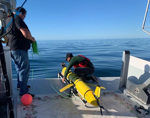
As recently as 2017, traditional means of visual surveillance such as airplanes and boats are used to survey the species movements and are still the primary method of observation. Although these are effective, a more rigorous remote monitoring approach is required to recognize common migration patterns and provide real time tracking of individuals. The new methods that are being piloted and developed are the usage and development of an underwater glider.
Transport Canada partnering with the University of New Brunswick (UNB) is piloting a project in which they have launched an underwater acoustic glider that will enhance the surveillance and monitoring of North Atlantic right whales. The acoustic glider was deployed in the Gulf of St. Lawrence in which it travels the shipping lanes and listens for acoustic calls of blue, sei, fin, humpback, and North Atlantic right whales in near-real time. The detections are transmitted every few hours and cross referenced across a database as well as validated by an analyst.
In addition to the glider – also put in place are Viking buoys which are buoys equipped with sensors that collect information on ocean and weather conditions and have recently been equipped with hydrophones that are able to transmit the signals at near-real time to manual acoustic experts.
Validated detections and any data relating to whale sightings is publicly available at http://whalemap.ocean.dal.ca/
Future Planning
Most recently the Government of Canada under the smart Whales initiative is investing 5.3 million to advance whale monitoring and the prediction of their movements through high resolution satellite imagery. The following projects and their objectives are as follows.
| Lead company | Collaborators | Project | Contract value |
| Stream 1: Detection and monitoring | |||
| Hatfield Consultants Ltd. | -University of New Brunswick-Dalhousie University-Duke University-AltaML-Canadian Wildlife Federation | Develop a system that will detect North Atlantic right whales using deep-learning algorithms, high-resolution satellite imagery, automation, and geoscience computing. | $1,199,520 |
| Global Spatial Technology Solutions Inc. (GSTS) | -Dalhousie University-Ocean Frontier Institute (OFI)-DeepSense-British Antarctic Survey-Bigelow Laboratory for Ocean Sciences | Develop a system that will detect North Atlantic right whales using machine learning and high-resolution satellite imagery hosted on the artificial intelligence-based maritime management platform, OCIANA™. | $1,102,417 |
| Fluvial Systems Research Inc. (FSR) | -INSARSAT Inc.-University of Ottawa-Canadian Whale Institute | Develop a system that will monitor North Atlantic right whales and their habitat using high-resolution satellite imagery. | $1,176,682 |
| Stream 2: Prediction and modelling | |||
| Arctus Inc. | -Takuvik (Laval University)-Hatfield Consultants-ACRI-ST-Anderson Cabot Center for Ocean Life, New England Aquarium-M – Expertise Marine-Bigelow Laboratory for Ocean Sciences-Merinov | Develop a modelling system to help predict the presence of North Atlantic right whales in the Northwest Atlantic shelf, including the Gulf of St. Lawrence and the Gulf of Maine. | $900,000 |
| WSP Canada Inc. | -DHI Water & Environment-Canadian Whale Institute-Dalhousie University-Institut des sciences de la mer de Rimouski | Develop a system that will provide near-real-time information about the forecasted presence of North Atlantic right whales and potential risks of encountering a vessel. | $899,582 |
If you would like to learn more or support the conservation of this amazing species, follow these links.
https://oceana.org/marine-life/marine-mammals/north-atlantic-right-whale
https://e360.yale.edu/features/at-sea-and-in-court-the-fight-to-save-right-whales-intensifies
References
https://www.narwc.org/right-whale-news.html
https://baleinesendirect.org/en/2020-north-atlantic-right-whale-monitoring/

