

International Geospatial Briefing for November 16th: Yana Gevorgyan as the next GEO Secretariat Director; Mapping Britain’s footpaths; GIS, fortified Kenya’s response to COVID-19; Time travel to US cities 200 years ago by Google experiment
Appointment of Yana Gevorgyan as the next GEO Secretariat Director
Yana Gevorgyan will be the next GEO Secretariat Director, effective from 1 July 2021. The Group on Earth Observations (GEO) announced this appointment on November 5.
She is presently the GEO Program Manager at the U.S. National Oceanic and Atmospheric Administration’s (NOAA) National Environmental Satellite, Data and Information Service (NESDIS).
Ms. Gevorgyan is experienced in building relationships with regional and international diverse groups. She believes that enhancing GEO’s core membership involvement will lead to GEO advancement. Read more here

“GEO is a manifestation of this force, and it has been my privilege to have worked with GEO for more than a decade. I look forward to working with the talented GEO Secretariat team to serve our members’ needs, and position GEO for a successful renewal of our mandate by ministers in 2025. This will enable us to collectively continue to realize the benefits of Earth observations to build a sustainable future for communities worldwide.”
Yana Gevorgyan
Slow map: Mapping Britain’s intercity footpaths
Our lives have been changed during the Coronavirus pandemic.
For instance, walking is incorporated into many people’s daily routine. Daniel Raven-Ellison, a geographer with 700 volunteers produced a map during the lockdown for anyone who wants to avoid cars or public transport on a long journey. This “slow map” represents the best walking routes between all of Britain’s towns and cities.
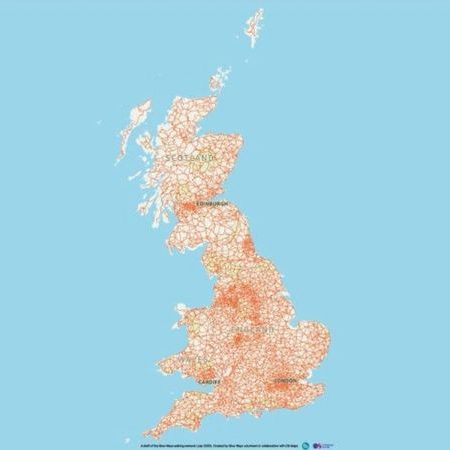
The next step of this project is finding more volunteers to try these routes to make sure they are safe, walkable and enjoyable. Read more here and click here to get more information about the slow map.
The ‘science of where’, or GIS, fortified Kenya’s response to COVID-19. Here’s how
Maps play an important role during the COVID-19 pandemic in the word. In Kenya, people and organizations applied GIS to gather, analyze and visualize spatial data for better decision-making during this pandemic. GIS is used to map the spread of COVID-19 across space and over time, find hotspots, sensitive populations, etc.
For instance, Kenyan health economist and financing researcher Edwine Barasa and colleagues uncovered big gaps in hospitals’ capacity for potential crisis management in the early phases of the pandemic. More about this analysis
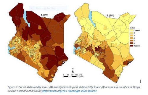
As other examples of how GIS has been used in Kenya to help in Coronavirus response are online dashboards of reported COVID-19 cases which are produced by Kenyatta University GIS laboratory and the health ministry. The maps simplified the data to enhance a better understanding of the dashboards for the public. Read more here
This incredible Google experiment lets you time travel to your hometown 200 years ago
Are you wondering how cities have been changed from 200 years ago?
Raimondas Kiveris, a software engineer at Google Research, created an open-source map called “rǝ”. This map represents US cities’ developments over time. With a slider above this map, viewers can change a year from 1800 to 2000 and see the cities’ land-use changes. The 3D button on the right side of the map provides a pedestrian-level view of the automatically 3D generated models of buildings on each block.
Historical fire insurance maps supplied accurate data for creating this map including information about building ages, sizes, heights and materials.
This software engineer believes that this map can be used in several industries naming video games and movies. He and his team launched an open-source project and asked librarians and map fans to help develop this map by adding more details such as building photographs. Read more here


