International Geospatial Briefing for Sept 28: Chinese launch failure; HERE Data access; Free Aerial Imagery basemap of New Zealand; SpaceX internet 700 satellites; GIS is powering solutions; Teaching disaster management through GIS games
China’s launch of new satellite fails
Jilin-1 Gaofen 02C, the new Chinese satellite failed to enter the preset orbit on September 12th. Read more here
HERE offers developers and data scientists direct access to rich geospatial data
HERE Technologies recently released HERE Data layers as a precise representation of cartographic features and attributes. They will serve as great resources for data developers and data scientists to access high-quality datasets. Administrative divisions, buildings, destination signs, hydrography, land cover, land use, navigable road, places and traffic signs are included in HERE Data Layers.
HERE Data Layers is available for all to access via the company’s Freemium developer plan at https://developer.here.com/products/data-layers. Read more here
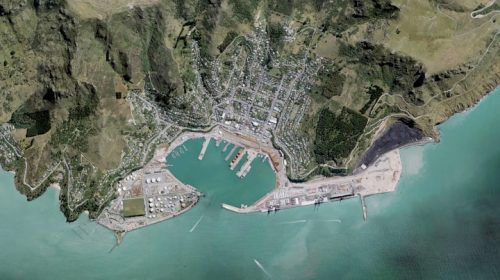
New LINZ Basemaps Showcases Aerial Imagery of New Zealand
Land Information New Zealand (LINZ) recently released the free Aerial Imagery basemap. It provides high-resolution imagery down to 5cm in some urban areas and 10m satellite imagery. Mainland New Zealand, Chatham and other offshore islands are fully covered in this basemap. Everyone can use LINZ basemaps with no cost as they are powered by authoritative open data sources such as the LINZ Data Service. Read more here
SpaceX looks to expand internet service with more than 700 Starlink satellites
SpaceX launched 60 Starlink satellites into Earth’s orbit on September 3rd. Elon Musk, SpaceX founder and CEO has a plan to create a constellation with up to thousands of Starlink satellites, so anyone on the planet can access to fast internet speeds.
According to SpaceX, Starlink satellites production is now 120 satellites per month. Astronomers are worried about extra points of light which will make the night sky observation harder. To address the concerns, SpaceX revised its satellites to be less reflective . Read more here

Mapping The Way Forward: GIS Is Powering Solutions To Global Challenges
“Geographic Information Systems (GIS) turns statistics and numbers into pictures and maps,” said scientist Dr. Rae Wynn-Grant. She is on a mission to track black bears. GIS helps her in story telling of where the bears come into conflict with humans.
GIS is used to visualize, analyze and manage data to better understand and solve issues we face today in the world. It also helps users from many different sectors such as governments, academia, businesses, etc make smarter decisions.
When GIS comes into classrooms, educators can represent lessons in interactive ways which students can see real people’s experiences in real situations. So young people can imagine themselves as urban planners, policy makers, scientists, etc. Also, GIS helps answer the famous important question: “Why do I have to learn this?”
Read more here
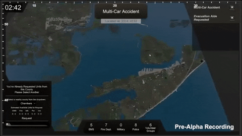
RIT researchers create serious games to teach disaster management and resilience skills
“I think using gamification to make learning spatial thinking more engaging is a great way to get people thinking,” said Brian Tomaszewski, lab director of RIT’s Center for Geographic Information Science and Technology . He led Project Lily Pad and Project Emergency Operations Center (EOC), two serious Geographic Information Systems (GIS) games which are developed by researchers of Rochester Institute of Technology (RIT). These games are created based on Hurricane Harvey on Aug. 25, 2017 which caused destructive flooding and many deaths in Texas.
Project Lily Pad and Project EOC are free to play and can be downloaded on GitHub
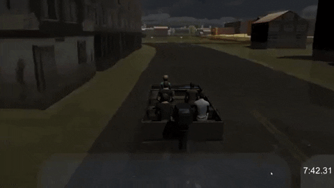
These games will be useful for teaching public, emergency managers and first responders about spatial thinking skills and the ways to help people resist and recover from disasters.
In 2018 and 2019, field data was collected and turned into 3D Environment game using CityEngine. Read more here