
International Geospatial Briefing March 8th: Geography, a cause for inequality; Drone Survey of a Wind Farm Access Road; Loss of soil study using satellite imagery; Japanese noisy children map; Minority-owned businesses map
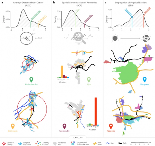
Geography can become a root cause for inequality when cities are built in a way that fragments social networks
A study by international scientists, including members of the Complexity Science Hub Vienna (CSH), shows that urban design can affect the social network arrangement in cities and afterward the economic inequality. It means if social networks are separated unevenly in cities, the income inequality will be higher over time.
The distribution of social networks relies on geography a lot. That is why the research concludes geography is a root cause for socio-economic equality in cities.
Urban sociology research says that people cannot easily build social ties when they are separated by large physical obstacles such as rivers, railways, highways or walls.
CSH researcher, Johannes Wachs
Read more here.
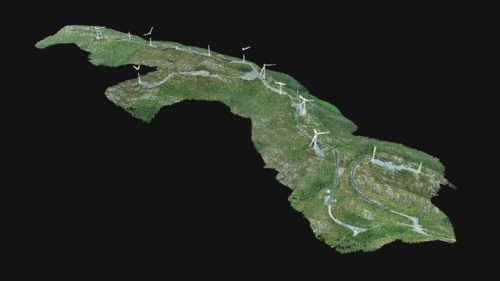
A Drone Survey of a Wind Farm Access Road
In Norway, renewable sources generate 98% of electricity. Specifically, wind energy is a popular source. However, maintenance of a large wind farm requires reliable and easy access through the whole farm for fast inspections.
Nærøysund Entreprenør had built access roads at the wind farm and asked Biodrone, a Norway-based company, to do surveying the construction of these roads using an unmanned aerial vehicle (UAV or ‘drone’). It is believed that drone technology is the best solution for this matter as it can save surveying time. However, the project can be challenging since tall structures in a wind farm are a potential crash risk.
Read more here.
How the Loss of Soil Is Sacrificing America’s Natural Heritage
New research, The extent of soil loss across the U.S. Corn Belt, by geoscientists of University of Massachusetts — Evan Thaler, Isaac Larsen, and Qian Yu— reveals a shocking topsoil loss in the U.S. Corn Belt. This means at best, 24% of Corn Belt topsoil has been removed by farming. At worst, 46% has been lost. This is a catastrophic loss as topsoil is not capable of being substituted.
These geoscientists used high-definition satellite imagery, a recent soil carbon index, and soil spectral data to show only B-horizon soil was found on the convex slope. This subsoil, with the lowest productivity, which is only exposed after A-horizon soil has been removed.
Read more here.
Japanese website maps neighbourhoods that have noisy children
The Dorozoku (street tribe) is a map that shows where noisy neighbourhoods by the sound of children or adults are located. Colourful circles in the map indicate places where it is not quiet with detailed information of the source of noise, such as children playing basketball, soccer, etc. on the street.
The map’s creator was criticized for increasing the intolerance of children and their natural activities especially when the country’s economy needs more young people to survive in the future. However, some parents believed this map which also shows places with more tolerant locales, helped them choose where to live.
Read more here.

Students’ GIS work to highlight state’s minority-owned businesses on ‘Greenlight Maine’ spinoff
Marine biology class of 2023 students, Salma Bezzat and Lydea Rowell, have partnered with the series “Elevating Voices”. The purpose of this show is to support different ethnic backgrounds and minority-owned businesses in the Maine area. For the show, 12 businesses are highlighted. These students create an interactive map using ArcGIS Story Map to showcase the stories of those business owners.
Read more here.


