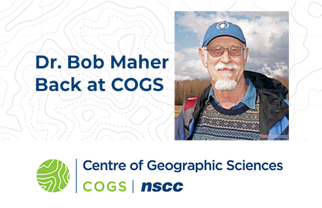
Interview with Ted MacKinnon: One of Nova Scotia’s most valuable geospatial resources
“Oh the Places You will go!” Part 3: “Continuing the COGServation”
I’ve been writing a series of articles and interviews highlighting some of the most interesting people I know in the Canadian geospatial community with a connection to one of the best GIS schools not only in Canada but the world. The Centre of Geographic Sciences (COGS) in Lawrencetown, Nova Scotia. This is another article in the series. You can see the rest of my articles here.
The writing process starts with thinking about what you know, researching, integrating new knowledge with prior knowledge to give your limited viewpoint added perspective, and examining things from new angles. When starting to write this, I thought, “What do I know about Ted?”
There’s “Ted,” the movie. Then there are “Ted Talks”. And there is the Ted associated with COGS; Geospatial-Ted.
His actual name is Edward “Ted” MacKinnon. Ted hails from Nova Scotia, attended COGS twice, and is currently employed with Natural Resources Canada.
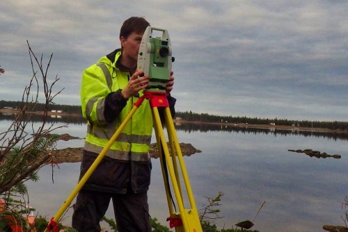
Boundary survey project for Parks Canada to help create a new National Park Reserve in Labrador
Ted runs two Twitter accounts (@tedmackinnon) and (@CanadianGIS). The Twitter handles and descriptions for these two accounts say it all about how much he is ardently supporting and promoting geospatial. Ted’s two accounts are among the largest and most influential social media accounts globally. With over 50,000 combined followers this is self evident.
Judging by the number of interests Ted includes in his Twitter profile, I thought I would dig a little deeper into the enigma. You can read more about Ted’s influential twitter success here.
Interestingly enough, those of us who “intersect” on the axis of geospatial evangelism all have one thing in common, even though we come from different backgrounds. We care about advancing and enhancing the larger geospatial community. The majority of our efforts are gratis: mentoring, shaping policy, working on standards, community advocacy and promotion.
Ted is a multi-faceted professional; well-rounded in many geomatics related disciplines. He has a GISP, has been certified in remote sensing, and has started to work towards getting a surveyors license. You can tell from his website: https://tmackinnon.com/ that Ted is a natural teacher in the way he shares his knowledge.
Ted has been President of the Geomatics Association of Nova Scotia (GANS) for the past two years, helping establish them as leaders within the Canadian Geomatics Sector. This exemplary organization is a sound one of which to be a part; for its networking events, publications and career resources. I especially like their geography poster series designed to educate high school students about geospatial careers. Every province should have a GANS-equivalent.
Anyone involved in the geospatial world quickly realizes how interconnected are the location components of surveying, geoscience, cartography, GIS, geodesy, bathymetry, geospatial intelligence, LiDAR, remote sensing, satellites, earth observation, and drones, et al.
I ask Ted about how his career has evolved
Peggy: You’re a native born Nova Scotian with deep roots in the Maritimes, your family was among the very first settlers. You have a degree in geology from Acadia. I see a real Nova Scotia theme developing in your life. What steered you to COGS?
Ted: While studying geology at Acadia University, I worked with several Professors who had extensively mapped several regions of Canada’s geology over their career, and they provided me my first taste of cartography through several mapping projects of bedrock geological formations of Cape Breton Highlands.
Around the same time I met Tim Webster who was working on his Master’s Thesis. Tim told me that remote sensing would compliment my science degree and invited me to check out the programs they offered at COGS. The remote sensing demonstrations got my attention and I attended COGS the next year.
Peggy: What was your experience at COGS like?

Centre of Geographic Studies
Ted: Unlike most COGS grads, I attended COGS twice, and both experiences were rather unique. The first time was back in the 90s when I received the Advanced Diploma in Remote Sensing & GIS. This was during the pre GUI days, so rather than point and click to accomplish something, we had to program code to do everything. Computers were also rather primitive and not as common, so we needed specialized hardware to process our satellite data; therefore most of my work was done using UNIX based machines. You also could not download data, but instead had to run algorithms that took several days to extract and build data from large disks that were delivered from the vendors.
This was well before Google Earth and online mapping, and it was always a challenge to explain to people what remote sensing and geomatics was. One of the highlights that year was a trip to present at a conference in Vancouver where we managed to get a tour to check out the RADARSAT satellite.
My second time at COGS, about 6 years later was much different because of computer software and hardware advancements and wide spread use of the internet. Although most people from the general public had never heard of the word geomatics, they had a better idea of what it actually was thanks for the growing popularity of Google Earth.

Working on a LiDAR project to help establish a power dam in San Pedro, Nicaragua
The program I studied was also more independent, and heavily funded by federal grants, so I had plenty of new hardware with which to work, and external clients to whom to deliver results. The program was more hands on, working with LiDAR and survey equipment, building upon my knowledge and skills obtained from my prior COGS education. The experience provided through this research allowed me to easily obtain relevant work in my field.
Peggy: What are some of the jobs you have held over your career?
Ted: I have been fortunate enough to work in many aspects in geomatics, including remote sensing, LiDAR, cartography, GIS and surveying. Also I have had the opportunity to work with academic research, private industry, and government (municipal, provincial, and federal). Through this large variety of experiences I have been able to stay current with most popular geomatics software packages and methodologies.
Peggy: Tell us about some of the interesting job-related places you have been.
Ted: While working as LiDAR Project Manager for about 6 years, I was fortunate enough to be able to travel all over North and Central America on a multitude of projects. I traveled up around the Arctic Circle down to the equator and everywhere in between.
This extensive travel is where my passion for geography started to grow and I really developed an appreciation for how big Canada really is. Along the way while spending time in various Canadian locations, I always tried to take some time to explore the local geography. Everything from having lunch at the Wildcat Cafe in Yellowknife to running along the water in Stanley Park while the filming of Marvel’s the Flash was taking place at the same time.
Peggy: What drew you to community advocacy through social media?
Ted: Originally, I got involved with social media as a way to drive traffic to various websites that I run. But, instead it turned out to be great way to keep up with the rapidly changing technology used by the geospatial community and a way to connect with people that otherwise I may have never run into before. It has turned out to be one of the best ways to share and promote information.
I still find it amusing when people come up to me, and it seems like they really know me somewhat yet I don’t recognize them. Then I learn that we never really met but they know me from online.
I ask Ted about geospatial intelligence or “GEOINT”
Peggy: A term that’s used more frequently these days is “GEOINT Revolution”. What do you think about it?
Ted: GEOINT, or Geospatial Intelligence is starting to appear all around us as it crosses into many other sectors beyond government where it originated about a decade ago. Our office like many others around the globe are starting to realize the importance and value of cutting out paper and the value of working more efficiently, so we are quickly adjusting to a digital format, providing all our data publicly and making more use of higher resolution imagery.
Earlier this year I was fortunate enough to attend CES in Las Vegas, the largest tech show in the world, which attracts some the world’s top business leaders and smartest pioneering intellectuals. This opportunity allowed me to better appreciate the amount of geospatial intelligence that the geomatics sector are deploying in a multitude of products and services, and how important location technology is becoming to our society. Through the various demonstrations and thousands of technology related exhibits, it is pretty clear that there certainly is a change taking place and at the center of it all is the importance of geospatial intelligence.
Peggy: Do you think that the Canada is prepared to meet the human resources demands of the GEOINT Revolution?
Ted: Quantity vs Quality: There an increasing number of colleges and universities providing some level of geospatial education to an increasing number of students, but the skill level and knowledge is nowhere near the level it used be. Perhaps the largest problem is that our younger generations are not learning programming skills.
Most people continue to blame the education system, but perhaps part of the problem is that the software companies are putting too much emphasis on making their software easy to use. I recall while working with the Canadian Geomatics Community Round Table that this is one of the key aspects that GeoAlliance Canada would address.
I ask Ted about the prospects of future geospatial professionals
Peggy: How can future professionals in the geospatial community best prepare themselves?
Ted: To really take advantage of the tremendous opportunity that GEOINT Revolution, the Canadian geospatial community will need to stop seeing themselves as a small niche sector and instead embrace the fact that geomatics technology has crossed over into virtually every other sector. Therefore geomatics is larger than ever before and growing exponentially. Stop trying to convince politicians about the importance of more geographic information education and instead convince other industries so they can push the value of enabling GEOINT orientated professionals in all sectors.
Peggy: Ted, Thanks for taking the time to share your experiences with me and the GoGeomatics community.
Ted’s answers caused many reflections and recollections for me. He again confirms what all geospatialists reveal: the opportunity for travel, connection, and networking and the broadening of experiences they provide-sitting in the Wildcat Cafe in the Northwest Territories conjures up all kinds of visions, almost being in a movie, a trip to Las Vegas. There are great people to meet in real life.
However, Ted references that we are fortunate to live in a virtual community.
“I still find it amusing when people come up to me, and it seems like they really know me somewhat yet I don’t recognize them. Then I learn that we never really met but they know me from online.” – Ted MacKinnon
I also value the online community of which I am a part even some of whom I have never met face to face. The trick is to be judicious. Separate the precious gems from the “dunnage” rocks. Some of the people you “virtually” meet will become more valuable to you in your career than a lot of actual real-life connections.
I had to smile when Ted referred to his training; and descriptions of changes in the hardware and software those of us involved in the bottom tier of the “GEOINT Revolution” had to wrangle. It is true that they forced you to acquire more programming skills and that now technology has made things easy. Knowing how things work gives you a deeper understanding which translates into better product. But there is a pro/con argument for everything and we are on a rapid path to building how this “GEOINT Revolution” can be applied. I think Ted is also saying keep abreast of changing technology or you may be left behind. ‘Easy’ can become complacency. A professional’s training only begins in college or university.
Make sure you Follow Ted on social media. He is proactively contributing to the geospatial community, knows what going on from coast to coast, and has plenty of valuable life experiences and advice to share. He is also a work in progress, as are all of us. We still have much work to do in Canada’s geospatial sector.
I think Ted, and a handful of others are both leading and challenging the Canadian geomatics sector. It is the time to come together and step up, and I agree with Ted 100%.