Karl Kliparchuk talks top GIS Education at BCIT in Vancouver, BC, Canada
GoGeomatics kicks off our series of interview with geospatial program across the country on the West Coast of Canada. We are highlighting some of the very best geomatics education programs in the world by talking to the instructors and professors who provide it.
GoGeomatics has a networking groups that meets once a month in Vancouver for drinks where you can meet and talk to some of the best geospatial practitioners in BC. You can learn more by clicking the banner below.

Vancouver GoGeomatics Group
There is no better source for all things GIS at British Columbia Institute of Technology (BCIT) than the GIS Program head and Instructor Karl Kliparchuk. The BCIT GIS program is one of the first GIS programs in Canada and remains one of the most popular.

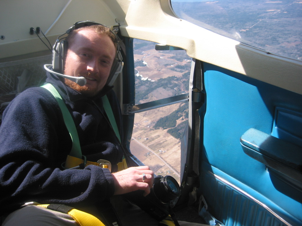
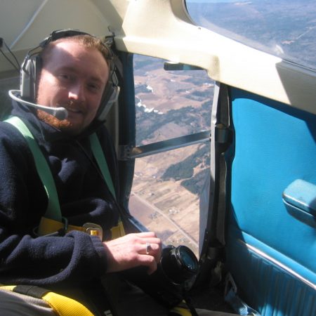
Karl Kliparchuk, M.Sc. BCIT GIS Program Head & Instructor
Good day to you Karl and thanks for discussing your career and the BCIT program. In order to get to know you a bit better, let’s start with: where are you from? What drove your passion to become a GIS specialist? Where did you receive your geography and geomatics education?
Karl Kliparchuk: I’m from Edmonton and took my B.Sc. and M.Sc. in Geography from the University of Alberta. I was originally in Computer Science but needed an application as programming on its own was not very interesting to me. I took a Geography course as an option and loved it. I ended up taking all the GIS and cartography courses I could, making Geography my major and Computing Science my minor. I did make use of my programming skills for my M.Sc. where I wrote a satellite image classification routine on a VAX computer.
Jonathan Murphy: What was your first job in GIS? What did you do and what was it like?
Karl Kliparchuk: My first job in GIS was with Advanced Satellite Productions in Vancouver, BC. They were the first company–as far as I know–to start making posters of various cities around the world using Landsat TM imagery. They had specialized image processing software that they were writing and they hired me to write the image classification software, and my role grew into sales as well. Working for a small company has its challenges but you get an opportunity to try to do many different things so great for experience.
Jonathan Murphy: Can you tell us a bit of the history of the BCIT GIS program? When did it start and how has it advanced over the years?
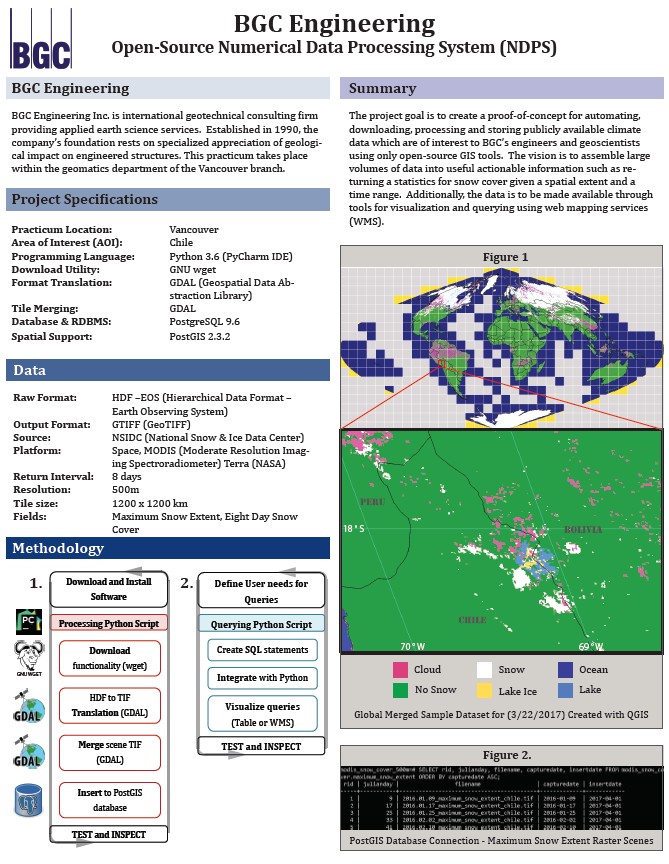
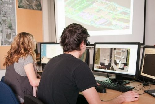
BCIT GIS Practicum python programming for BCG Engineering
Karl Kliparchuk: The BCIT GIS program started in 1987 I believe, as that is the year that I moved to Vancouver, and I remember coming to the BCIT campus in 1988 to speak with the department head at that time, who had just started his job. The program always worked with ESRI’s ArcGIS suite of software. Our hardware changed over time from UNIX desktop computers, to PC desktop computers, now to CITRIX-based desktop computers connected to our servers. We have always been very technical, teaching programming and database management, as well as GIS analysis and some surveying. The programming languages have changed over time as ESRI used different programming languages. AML, Visual Basic, and python were all taught for customizing ArcGIS. We also have taught various programming languages in general like Java and php. Programming in the past was for a desktop computer, or maybe a server, but now we have progressed to mobile environments where we create Android apps. The ESRI software has also evolved over time, so we now also teach students how to use ArcGIS Online, StoryMaps, and how to build native apps.
Jonathan Murphy: BCIT offers a number of options for students. There is an Advanced Certificate, Advanced Diploma as well as a Bachelor of Technology. With so many options why would a prospective student take one and not the other?
Karl Kliparchuk: The Advanced Diploma is the most popular credential we offer. In the full-time program we take 45 students per year. Approximately 41 of those students are for the Advanced Diploma. It is meant for people primarily who have a B.Sc. already and want to add to their technical GIS skills. We get many B.Sc. students from SFU and UBC for example. The Bachelor of Technology is meant for people who may have a diploma from a technical institute like BCIT, or who have done 2 years of University, but not yet graduated with a B.Sc. These people want a Bachelors degree. They take the same GIS technical courses as the Advanced Diploma students, but then have to take additional Management and Liberal Arts courses, and get 6 months of GIS work experience. These two credentials are also offered through our part-time studies through online courses so you can be anywhere in the world. You cover the same material in the part-time studies courses as you do in the full-time program, but you can complete your credential over a longer time period. The Advanced Certificate is only offered online through part-time studies. It is 7 courses that cover a little GIS background, ArcGIS basics and analysis, databases, surveying and cartography, followed by a Capstone project. It is meant for people that have a career, e.g. civil engineer or forester, and would like to add GIS skills to help them in their daily work. It is not meant to make them a GIS geek like the Advanced Diploma or Bachelors degree students, but gives them enough knowledge to produce maps and to talk to GIS technicians to make sure that they produce the kinds of information products needed for their projects.
Jonathan Murphy: What makes the BCIT program so specials? How many instructors are there? How does the program stay current with industry needs?

BCIT GIS Practicum – address geocoding for BC CDC
Karl Kliparchuk: As mentioned earlier what makes us special is that we are so technical. Lots of programming, databases and advanced GIS analysis. Also I should mention that all Advanced Diploma and Bachelors students also have to undertake a project or a practicum with a sponsor, e.g. an engineering dept in a municipality, a forestry company, environmental engineering company, real estate company, etc. so that they get to put their GIS skills to use and get real-world experience. Many of our students get hired by their sponsors.
We have 5 full-time instructors, who also teach some of the part-time studies courses, and we have at least 5 more part-time studies instructors. We attend the ESRI User conference here in Vancouver each year, attend online ESRI seminars, take sabbaticals to study new technologies (I took a sabbatical earlier this year to study how to use Virtual Reality and Augmented Reality software with GIS), attend Safe Software seminars, and anything else technical related to GIS. We also have a Program Advisory Committee with people from various companies and government agencies that use GIS. We meet every 6 months to discuss what is happening in GIS in their industry and give us guidance on things we could offer or change in our curriculum so that we are always providing current skills for our students.

BCIT GIS Practicum – JSON for Safe Software
Jonathan Murphy: With technology changing so rapidly what are the core skills in both programming and software proficiencies do you think every GIS professional should have today to future proof their careers?
Karl Kliparchuk: As ESRI is so widely used, you should learn how to code or script in whatever language they are currently using. With the web becoming more integrated into everything, learning web languages like HTML5, Javascript, python and php are also important. Mobile is also growing, so learning Java and C# would also be recommended.
Jonathan Murphy: What are the types of jobs that BCIT graduates can look forward to?
Karl Kliparchuk: Our students get jobs in all sorts of companies and government agencies. Many have been hired by Esri Canada and by Safe Software. Mining companies, engineering companies, municipal governments, real estate agencies, environmental companies, and much more. It helps if the student before coming to BCIT has a degree in some other field so that they can narrow their search for a job, than just being a generic GIS person. GIS is a tool that you can use in various industries. If you have industry knowledge plus GIS that is a great asset. Our student projects and practica help students with this.
Jonathan Murphy: Karl thanks for sharing your program with the community. We hope to see you and your students at the Vancouver Back to School GoGeomatics social this September 25th at the Legion. Join the local geospatial community as we welcome new and returning students to our industry. RSVP here. I will be there as well.
Karl Kliparchuk: See you soon with our new batch of GIS students.