

Kincardine to Ottawa, Ontario Drive: Testing Google Earth vs. ArcGIS 10 GPS Capabilities
I had just finished a trip in Kincardine, Ontario and was preparing for the upcoming eight-hour long drive back to Ottawa. I am interested in GIS and therefore decided to test out some software capabilities during the ride. I was not going to be driving, and so it seemed like the perfect opportunity to explore two GIS programs and their ability to track our travel through a GPS. I decided to use ArcGIS 10 because I have a Home Use license, and compare it with Google Earth because it is free software available to all users. I recorded the process and have noted strengths and weaknesses to document the test because I have never tried it before.
I was using a Dell Precision M4300 Microsoft Windows XP laptop with a Global Sat Technology Corporation GPS BU-303 GPS because that is what was available to me. Before setting out, I maxed out the available memory cache in Google Earth while I still had Internet access. Basically this means I determined a route of travel and then zoomed in and out along the route in Google Earth to store the information. I paid particularly close attention to cities and where there would be a change in the direction of travel so I would have a clear map of those important areas.

Figure 1. Google Earth cache size options
The memory cache is data stored in your systems RAM, to a maximum of 500MB. This information can be retrieved quickly, but is lost when you close the application. The disk cache is data stored on your hard drive to a maximum of 2000MB, and which persists after the program closes. Thus, if you have an issue, you can exit the program without losing your stored data.
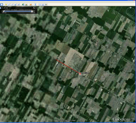
In the Google Earth GPS Import dialog box, I set the polling interval to 10 seconds and selected ‘Automatically follow the path’. This would allow for real-time tracking to occur. Every time the GPS recalculated my position, it zooms into your current position. This was extremely bothersome when trying to perform work in a different area compared to where the vehicle is located or when zooming out and panning around to other areas (Figure 2). The red line indicates the distance traveled during the predetermined polling interval of ten seconds. The red ‘x’ shows which direction I was traveling. You can see that I did not zoom in very far when setting the memory cache, thus a blurry yet doable map.

Figure 2. Google Earth ‘Automatically Follow the Path’ Option Selected
I then turned off the ‘Automatically follow the path’ option that led to no unnecessary zooming. However it did not show the current ‘position’ icon and therefore does not indicate in which direction you are traveling (Figure 3). You can see that I had zoomed in quite close when setting the memory cache in this area due to the higher resolution map compared to Figure 2.

Figure 3. Google Earth No ‘Automatically follow the Path’ Option Selected
I then began to receive a COM Port error, at which point Google Earth stopped working, leading me to believe that the program is unstable. I started troubleshooting: checked GPS Information, COM Port error, restarted GPS information and worked, closed GPS information. I then restarted the Google Earth GPS Import, but in using the Google Earth GPS Import, you are not given the option to select which COM port to use. You must let the program read various ports to find the correct port. When there are 20 plus communication ports it is time-consuming.
The Device Manager indicates that the device is working properly and is reading COM8 but there is no display in the Google Earth window.

Figure 4. Google Earth Crash
I tried a different USB port to connect GPS to computer. I then closed Google Earth knowing I would lose the ‘Memory Cache’ because that data is stored in the system RAM, but I had exhausted all other options. The GPS was then working, but reading COM5. Again, I closed Google Earth because the GPS stopped working in Google Earth, at which point it then would not open.
Considering Google Earth is very unstable and now failing, I launched ArcGIS10 to see how it would fare. I used ESRI based data for the road network. This was not accurate for the scale of data we needed, therefore making it look as if we were not driving on the roads. This would cause a larger issue if the user were driving with little or no knowledge of the area. The arrow does not provide correct directionality when vehicle is stopped. It will not remain facing the same direction, and will spin around. This would be cause for concern when a user would use a rest stop and then want to continue travel.

Table 1. ArcGIS 10 GPS Attribute Table Options
Table 1 illustrates the options available when using a GPS in ArcGIS10. As a line, you can only have the attributes selected at the start and end points of the line. If you choose to log as points, it will calculate all the data for the attribute table at every (I chose one-) second intervals (Table 2).

Table 2. ArcGIS 10 Sample Data Points from Kincardine, ON to Ottawa, ON
Table 2. ArcGIS 10 Sample Data Points from Kincardine to Ottawa, Ontario
Overall, it was found that using Google Earth did not work well as it was unstable. Also, because there is a limited memory cache size, making it unusable for long distance travel without Internet access. The software is free for download for both Windows and Mac users, and with little GIS knowledge you can be on your way. ArcGIS10 had many attribute options, allowing for more data to be collected in the same amount of time. The software is expensive and background data would be needed to serve as a map base. It appeared to be more stable and does not require Internet use. Happy GPS-ing!


