


Local Action & Geomatics: the Gowgaia Institute on Haida Gwaii
This blog is a sequel to last month’s discussion on ‘think global, act local‘. It looks at the the Gowgaia Institute and their use of Geomatics technologies, including an interview with John Broadhead a director of the institute. First, we need some context.
Geography:
Haida Gwaii has a population of approximately 5000 people.The Haida make up 45% of the population on the islands.
Gowgaia Bay lies on the west coast of South Moresby Island between Ninstints, on Anthony Island and the Skidegate Channel, which separates Moresby from Graham Island. Gowgaia Bay is situated within Gwaii Haanas National Park Reserve, National Marine Conservation Area and Haida Heritage Site. The Gowgaia Institute is named after Gowgaia Bay, but is located in Queen Charlotte.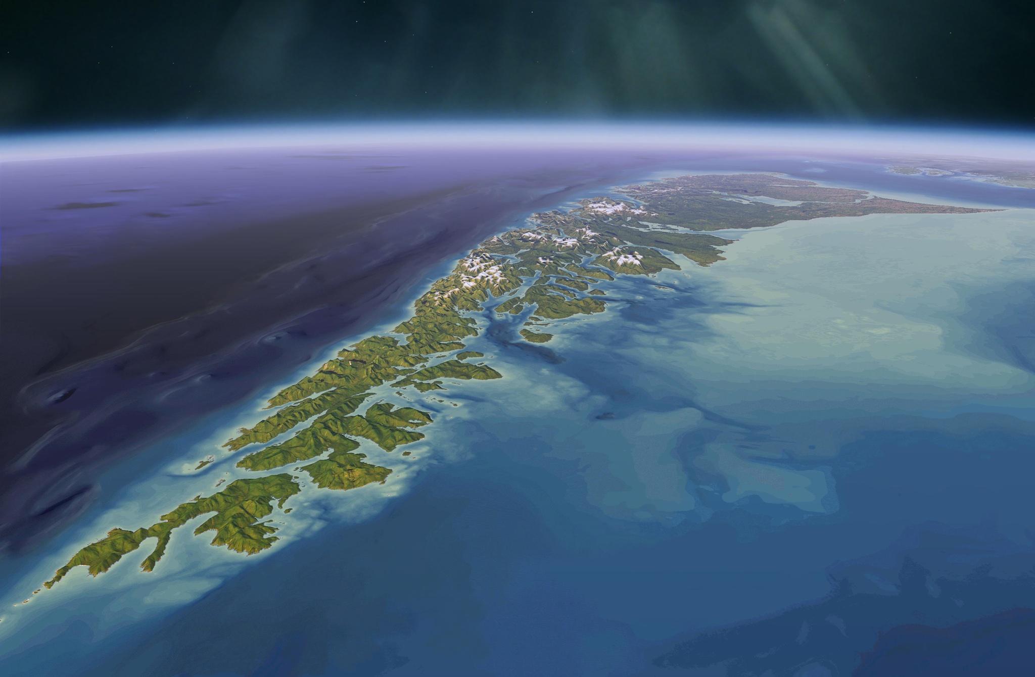
History:
Recently Louise Takeda (2015) has documented the story of land use planning on Haida Gwaii. In her book ‘Islands’ Spirit Rising’ she gives a useful context on the history of the Gowgaia Institute, through the following quotations over the years.
“The signing of the Gwaii Haanas Agreement marked a triumphant conclusion to the nearly two-decade-long battle to protect Gwaii Haanas and a major turning point for the Haida. On achieving their goals, the Haida recognized the role that environmentalists had played in rallying public support and attention, and preventing the government from crushing their resistance efforts. Environmentalists acknowledged that ‘only the Haida can keep these islands from being completely transformed by the larger industrial plans for the island’. Local environmentalist, John Broadhead would subsequently found the Gowgaia Institute, a research organization dedicated to promoting sustainability on Haida Gwaii, and would continue to work closely with the Haida.” p.64.
“Meanwhile, the Haida Forest Guardians and the local Gowgaia Institute were developing their own mapping and planning capabilities. The relationship between Gowgaia and the Haida Nation was formalized in a protocol agreement in which Gowgaia acknowledged the hereditary title and leadership role of the Haida Nation, and the Haida committed to consult with and respect the Institute (Council of Haida Nation and Gowgaia Institute 2002). Gowgaia’ co-director, John Broadhead was at the cutting edge of mapping technologies, and with his assistance the Haida expanded their own technical and mapping expertise.” p.82.
“The Gowgaia Institute, the most steadfast environmental watchdog for the past three decades, has now turned its attention to the Haida title case and the mapping of Haida place names.” p.203.
The SpruceRoots web site (spruceroots.org) describes the mandate of the The Gowgaia Institute.
“Our goal is to protect and sustain all of the values and functions of the islands’ ecosystems, to ensure that the fish, forests and natural beauty that we enjoy today are here in equal measure for our children and the generations to come. This means adjusting the current governing management principles, economic structures, rate of resource extraction and system of protected areas, accordingly.”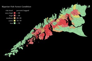
Interview with John Broadhead Director of the The Gowgaia Institute
Bob Maher: When was the Gowgaia Institute formed ?
John Broadhead: 1994
Bob Maher: Was it always a non-profit institute ?
John Broadhead: The Gowgaia Institute is a project of the Earthlife Canada Foundation a federally registered charity and a provincial non-profit society.
Bob Maher: What was the first map product by the Gowgaia Institute ?
John Broadhead: The first maps showed the pattern and extent of logging on Haida Gwaii. During the 1990’s, every two years we produced maps from Landsat images showing the changing extent of logging. We distributed them as small posters free to the residents of Haida Gwaii and other interested parties. We later produced a series of large three foot posters. Over time, we incorporated forest cover data and air photos to produce an animated map – one hundred years in as many seconds.”
Bob Maher: When did you develop your interest in cartographic design ?
I had a background in graphic arts and math. We assembled a small team of people with the skills and tools to use GIS and graphic design to create some interesting maps about fish and wildlife habitat and what was happening to them. They’ve played a role in legal proceedings and land use policy.
Bob Maher: Who, or what were the influences ?
John Broadhead: Edward Tufte. If you want to make meaningful maps and other information displays, study Tufte. The ultimate influence has been the place itself, being here and learning about the land and sea with Haida and other friends and colleagues throughout the years.
Bob Maher:How did you gain access to digital cartographic technology ?
John Broadhead: We raised funds from grant-makers throughout North America. We bought it. We put together an in-house computer network, PC and Mac running Esri software, EPPL7 and Adobe Photoshop.
Bob Maher: Was that a challenge on Haida Gwaii ?
John Broadhead: Not really. Our goal was to create accurate, verifiable maps from satellite imagery. The work was painstaking, time-consuming and required attention to detail. We didn’t really need high speed Internet. Rather, we required a quiet workspace, time to learn and think.
Bob Maher: What tools do you use today ?
John Broadhead: The same, mainly Esri and Photoshop, some QuickTime and a lot of Excel spreadsheets? We have access to the same technologies. We also used Google Earth to work with Haida elders on mapping Haida place names and locations.
Bob Maher: I have seen some beautiful image/map products on the island. Is there a web site for others to see this work ?
John Broadhead: Over the years, we produced over a hundred different maps of Haida Gwaii for different purposes but we published them far more in print than digitally. Our web site at spruceroots.org will show you a few of our maps but it’s due for an upgrade in the near future.
Bob Maher: What are you currently working on ?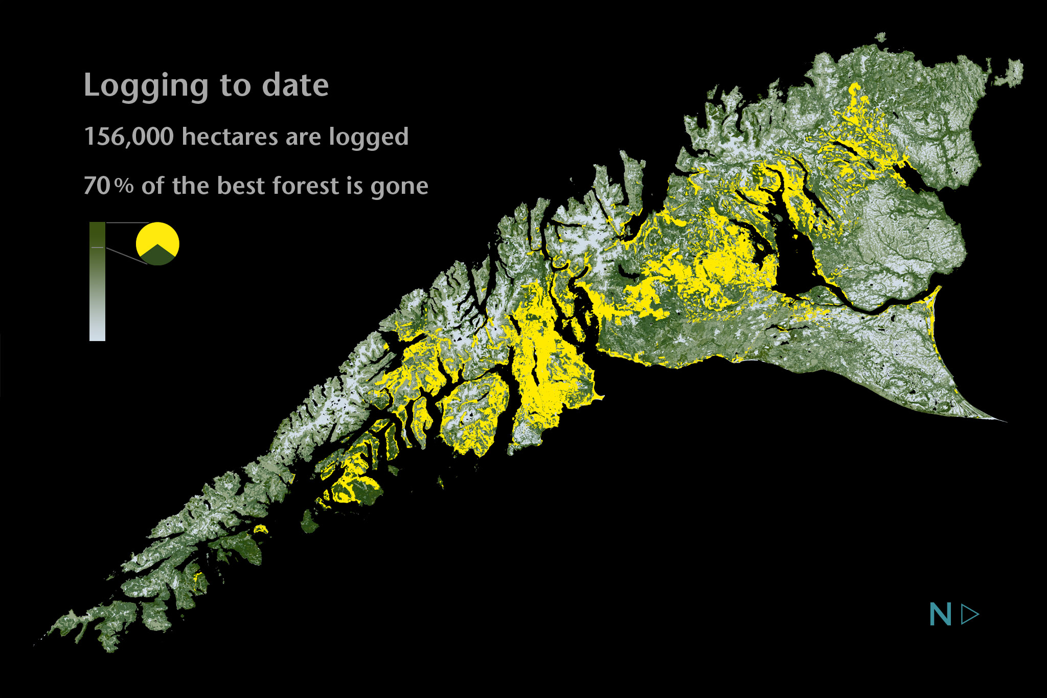
John Broadhead: We’re looking at the options for creating an online, interactive atlas of Haida Gwaii to publish many of the maps just referred to, and new ones containing new geographic information and technological capabilities. A big, ambitious project.
Bob Maher: Do you see a new generation of Cartographers on Haida Gwaii ?
John Broadhead: Each year, I make a couple of presentations to higher education students in natural resource management on Haida Gwaii and there are always students interested In Mapping and the atlas project. Ideally, students in local high schools could spend some time with university students in the UBC semester program and learn something about asking questions and answering them with maps.
Bob Maher: ‘Without access to mapping technologies, it would not be possible to effectively communicate and share the the unique qualities of ‘place’ on Haida Gwaii. Thus the tools were instrumental in the changes in perception that have happened over the last several decades. ‘ Do you agree ?
John Broadhead: GIS and information design tools were essential to bringing about the social and institutional changes arising from the public land use planning process and the emergence of Haida Title in law.
Mapping tools allow us to model the existing industrial paradigm, to analyse the economic and environmental costs and benefits, and to illustrate irrefutably how unsustainable it was. They help to identify and portray the options and essential elements of a new, more sustainable paradigm, including unprecedented levels of protection for fish, wildlife and plant habitats. They were instrumental in galvanizing a well informed constituency for change, from local residents to senior government ministers.
Wherever you are, you need good data, meaningful content and worthwhile purpose.. You need information tools for analysis and verification, and graphic design for publication and communication. You need to know how to use those tools. You need imagination and a sharp pencil.
On Haida Gwaii, Louise Takeda has defined this purpose as follows:
‘A place-centred ideology now united a large number of islanders. Threatened by the prevailing economic and political system, they shared a connection to the land, a concern for the well-being of the forests and stability of their communities, an attachment to a unique way of life, and an emerging consensus around respect for Haida title and shared local control.’ p.161.
For those interested in learning more about life on Haida Gwaii, I would recommend the latest book by Susan Musgrave, ‘A Taste of Haida Gwaii. Food Gathering and Feasting at the Edge of the World’. This ‘cook book’ gives the reader a remarkable ‘sense of place’ through a combination of stories, photographs, art and recipes.
Sources:
Louise Takeda. 2015. Islands’ Spirit Rising. Reclaiming the Forests of Haida Gwaii. UBC Press, Vancouver.
Susan Musgrave. 2015. A Taste of Haida Gwaii. Food Gathering and Feasting at the Edge of the World. Whitecap Books, Vancouver
Christine Lowther and Anita Sinner. 2008. Writing the West Coast. In Love with Place. Ronsdale Press, Vancouver. It contains Musgrave’s article, ‘An Excluded Sort of Place’.
Edward Tufte. Check web site www.edwardtufte.com for books and course on ‘Presenting Data and Information’.
UBC Haida Gwaii semester program. Check web site www.haidagwaiisemester.com
Spruce Roots. web site spruceroots.org


