
New Autonomous Airborne Mapping Solution Redefines Industry Expectations
Teledyne Optech is pleased to announce the latest addition to its innovative line of airborne laser terrain mappers, the Optech Eclipse.
The Eclipse is the first airborne collection system that tightly integrates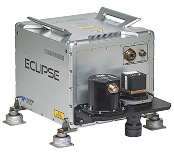 both passive and active imaging sensors with fully autonomous data collection on low-cost platforms. Designed specifically for efficiency in smaller project areas and corridor applications, the Eclipse combines an innovative sensor motion detection system with an eye-safe, high-performance 1.5-micron laser and a high-resolution imaging system for the automatic collection of high-fidelity lidar data and camera imagery, completely eliminating the need for a system operator and operator interface.
Capable of collecting 4-25 pts/m2 from a rapidly-moving aircraft, the Eclipse incorporates a rotating polygon scanner and a fully electronic camera and shutter system for high productivity with maximum reliability. Lidar and image data are simultaneously written to a single removable SSD data cartridge and processed in Teledyne Optech’s popular Lidar Mapping Suite (LMS), a full-featured lidar and image processing workflow that includes rigorous least-squares lidar calibration methods, photogrammetric bundle block adjustment, inertial boresight capability and intensive accuracy quantification. Boasting Teledyne Optech’s industry-leading measurement precision for exceptional data quality, the Eclipse enables high-precision surveying with an integrated Applanix OEM POS AV system.
“Reducing costs is the mantra of today’s service providers,” said Michael Sitar, Teledyne Optech’s Airborne Business Manager. “By eliminating the operator from the equation, we are able to reduce operating costs significantly. Coupled with high-performance and high-accuracy capability, and a relatively low price, the Eclipse is the new standard for low-cost, on-demand remote sensing applications.”
First shipments of the Eclipse are planned in Q3, 2016.
Find out more at www.teledyneoptech.com.
About Teledyne Optech
Teledyne Optech is the world leader in high-accuracy lidar 3D survey systems, integrated cameras, and productivity-enhancing workflows. With operations and staff worldwide, Teledyne Optech offers both standalone and fully integrated lidar and camera solutions for airborne mapping, airborne lidar bathymetry, mobile mapping, terrestrial laser scanning, mine cavity monitoring, and industrial process control, as well as space-proven sensors. Teledyne Optech supports its clients with an around-the-clock team, on-site service, and regular efficiency enhancements to the workflow of its integrated systems. Accuracy and productivity matter!
For further information, please contact your Regional Sales Manager or:
| Wayne Szameitat
International Sales Manager Teledyne Optech 300 Interchange Way Vaughan, Ontario, Canada L4K 5Z8+1 905 660 0808inquiries@teledyneoptech.comwww.teledyneoptech.com |


