New Brunswick: 1st Canadian Province to Complete Lidar Coverage with an Open Data License*
Re-posted from Bernie Connors
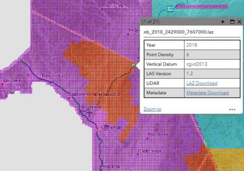
Monday, April 8, 2019, New Brunswick releases the 2018 lidar data for public download and becomes the first Canadian province to achieve complete aerial lidar coverage under an open data license.
In the summer of 2018 the Government of New Brunswick (GNB) completed its aerial lidar collection project. All the lidar data is available for download now. The data includes over 100,000 files and totals 7.2 terabytes of compressed LAZ files. These totals include duplicate coverage in some areas. The files can be downloaded one at a time with a simple point a click interface or, for larger downloads, the lidar index can be used to prepare bulk downloads. More details on downloading NB’s lidar data can be found here.
Lidar data collection began in New Brunswick around 2009 with different organizations purchasing small datasets for their internal projects. In 2013 GNB began collecting lidar data to support the forest inventory. Initially the lidar data was collected at 1 point per square metre but in 2015 the point density was increased to 6 points per square metre and a new campaign to collect lidar data over the entire province began. Additionally, the new Canadian Geodetic Vertical Datum of 2013 (CGVD2013) was adopted in 2015.

Over 4 summers, from 2015 to 2018, the province was completely covered in aerial lidar data collected at 6 points per square metre. There is some variation in the classification of the lidar point cloud: in 2016 the building classification was added and in 2018 the water classification was added.
Bare earth digital elevation model (DEM) files are still being processed but many are already available for download. GNB is currently planning additional lidar derived products. Future lidar derived products may include digital surface models (DSM), hydro flattened DEM, contour lines, hydro enforced DEM, slope maps, and aspect maps.
A small gap remains in our lidar coverage. The gap represents about 212 km^2 that need to be reclassified. The reclassification will be completed over the next few months.
* In 2009, Canada’s smallest province – Prince Edward Island, completed aerial lidar coverage of its territory but it has not yet been released as open data. PEI still charges a fee to obtain copies of the lidar data collected by the provincial government.