NV5 Geospatial Helps Okanagan Basin Water Board Protect Important Local Communities Through Near-Shore Topobathymetric Lidar Survey
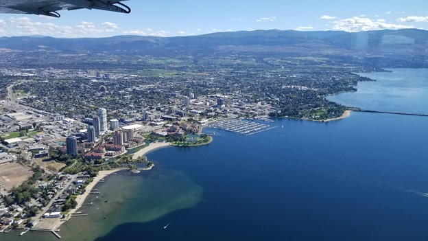
The Okanagan Valley in British Columbia is one of Western Canada’s most attractive tourist destinations, with local communities offering a range of active and relaxing activities organized around the region’s many lakes and rivers. The area is also home to a vibrant collection of wineries, and the Okanagan Valley wine region has grown to become the second largest in Canada.
But while the Okanagan Valley’s beautiful waterways make it an appealing destination for tourists, those same lakes and rivers now present increased risks of flooding to surrounding homes, businesses and infrastructure. On larger bodies of water like Okanagan Lake, wind-driven wave action can create destructive waves more than one meter in height. As the frequency of extreme weather events increases due to climate change, Okanagan Valley communities are at higher risk of potential flooding and economic damages.
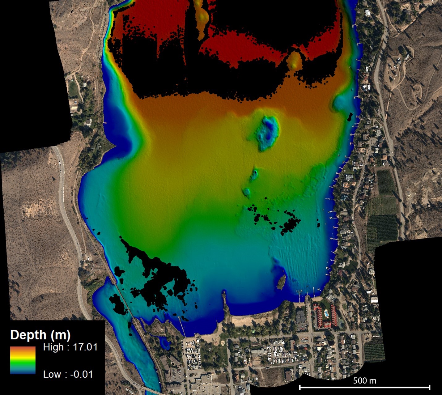
In order to better understand the potential flood risks, and to establish new policies for flood construction levels, the Okanagan Basin Water Board (OBWB) hired NV5 Geospatial in 2021 to conduct a near-shore topobathymetric lidar survey of seven major lakes in the Okanagan Valley. The OBWB is a local government watershed agency with a mandate to support sustainable water management across three regional districts in the area. The goal of the topobathymetric lidar survey was to collect data to support wave and surge modeling, resulting in more accurate flood construction levels for each individual shoreline segment. However, the new, precise data could also be used for several other purposes, ranging from educational materials for local universities, to habitat mapping for aquatic life, including plants and fish common to the area.
Safe, efficient lidar acquisition
The Okanagan Basin lidar survey coincided with one of the most extreme wildfire seasons in the history of British Columbia, presenting a range of challenges and safety concerns for data acquisition. Many of the lakes in the Okanagan Valley provide water for aerial firefighting, resulting in air traffic control restrictions for other aircraft hoping to fly in the same area. The extensive smoke from nearby wildfires can also severely limit the effectiveness of lidar surveys.
The OBWB expected NV5 Geospatial to conduct the lidar survey efficiently in order to complete all flights within a brief weather window without risking the safety of the flight crew. Recognizing NV5 Geospatial’s broad experience in the Pacific Northwest, where wildfires are an annual reality, as well as the company’s significant safety protocols and certifications, the OBWB maintained confidence in the company’s ability to complete the assignment as planned. NV5 Geospatial maintains a Stage 1 certification of the International Standard for Business Aircraft Operations (IS-BAO), confirming that the company has established an appropriate Safety Management System.
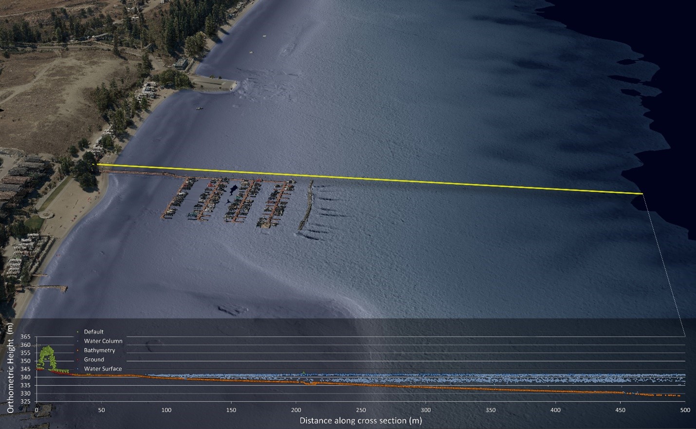
The target depth of the topobathymetric lidar survey was 10 meters, or 1.5 secchi depth in those areas where it wasn’t possible to achieve 10-meter penetration. Additionally, the OBWB expected the new survey to overlap with a previous topographic lidar survey conducted in 2018 in order to provide a continuous digital elevation model. NV5 Geospatial’s capabilities uniting topographic and bathymetric lidar data in previous projects demonstrated the team’s ability to meet the requirements.
The scope of the topobathymetric survey also presented an additional layer of complexity, as one section of the survey crossed into United States territory. Relying on the company’s previous experience in both regions, NV5 Geospatial coordinated with the International Joint Commission and other relevant local agencies in order to conduct both Canadian and U.S. segments of the survey. A comprehensive picture of the Okanagan Basin watershed was essential in order to inform the long-term projects and modeling that would follow the lidar survey.

Precise performance
NV5 Geospatial conducted the essential flights for the topobathymetric lidar survey in September and October of 2021, completing the acquisition phase of the project within the crucial weather window. The surveys successfully achieved the OBWB’s desired 10-meter depth in most areas, and NV5 recently delivered the complete package of data and imagery to the customer. The exceptional depth penetration and data precision will provide the region with highly accurate tools to create new wave and surge models.
“The outstanding quality of data delivered by NV5 Geospatial provides us with a tremendous opportunity to conduct new research and modeling in the Okanagan Valley,” said Dr. Anna Warwick Sears, executive director of the Okanagan Basin Water Board. “We have seen significant interest from local universities, academics, and organizations that would like to use this data to inform wave modeling, hydraulic modeling and other creative research. NV5 Geospatial’s expertise in topobathymetric lidar and imagery will help safeguard our region against the evolving impacts of climate change, so future generations will continue to enjoy everything that our beautiful region and its waterways have to offer.”
While Canadian regional and local governments have conducted several marine and coastal bathymetric lidar projects, the nation’s extensive inland waterways and lakes have yet to be fully surveyed and documented. The Okanagan Valley project offers a clear example for other government watershed agencies regarding how a topobathymetric lidar survey can be successfully organized and completed, as well as the many potential uses for high-quality data on local lakes, rivers and other watercourses. As climate change continues to produce flooding, wildfires and other extreme weather events throughout Canada, government agencies will need to rely on precise data to build resilience and proactively protect against physical and economic risks.