

Paul Barker: What is Web GIS? Exploring the ‘new’ GIS
GIS has always been an integral part of forward thinking organizations. However, it has long struggled to break out of the “back office”. I could fill a book with that struggle, but at the moment the past isn’t terribly relevant because I’m focused on looking forward. Over the past few years, those barriers and hurdles have been crumbling allowing us to break into an exciting new time known as “Web GIS”. Web GIS has been the catalyst for something very interesting. At some point over the past few years GIS suddenly became a “cool” career (I’ve felt that way for 15 years, but others didn’t share my enthusiasm, and quite often just assumed I made maps for a living). GIS has always touched many disciplines but right now it’s poised to explode into something truly pervasive and exciting. Understanding and embracing this change is an essential part of migrating into the next generation of information management.
For many people, “Web GIS” can seem overwhelming, abstract and intimidating. Demystifying and harnessing this new and exciting pattern affords a tremendous opportunity to add value to your organization and stakeholders. So what is Web GIS? The easiest way to answer that is: Web GIS is a pattern for sharing and collaborating around information with the goal of answering questions faster, making more informed and effective decisions, and maximizing your investment in spatial data. It is a pattern to get data out of the back office where it’s locked away and difficult to use, and get it in the hands of people who need that information. Making information accessible is only a part of the equation. What really brings Web GIS to life and makes it exciting is leveraging focused and purpose built apps (web, desktop and mobile) to abstract away the complexity of GIS and help the end user work efficiently.
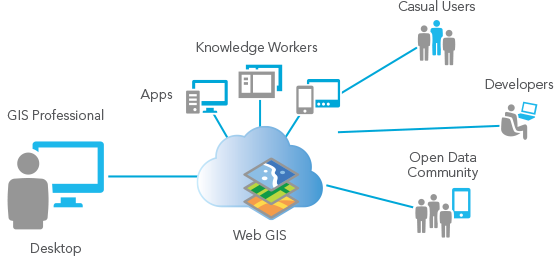
The Web GIS model: Publish data, build/configure tailored apps for your audience and maximize the value of your data (image courtesy of Esri)
So what sort of things can you do with Web GIS? The short answer is you’re largely limited by your ambition, but here are a few ideas. You could put the ability to report health and safety concerns into the hands of any employee with a smart phone. Empower and engage the public and stakeholders to provide you with meaningful feedback on capital improvement plans. Improve transparency by showing where your snow plows are in real time. Build a dashboard for your mayor so that it’s easier for him/her to keep their finger on the pulse of the city. Empower your community to become citizen scientists and report information back to you about species, weather, and more. Tell compelling stories about your community through maps. You really are only limited by your own imagination so don’t be afraid to dream big.
Some of you may look at the diagram above and say “We’ve been doing this for years”, and there is some truth to that statement. We’ve had a decade of data discovery portals, internet mapping, and websites that dabble in open data. The goal of Web GIS has been around since the days of ArcIMS. Many of us ended up building all of the components of a Web GIS but not the solution, what ultimately happens in those cases is that there is too much friction because those individual components are not connected and you never realize the full potential of your efforts. Over time, the cost to maintain and update those components increases and ultimately, they get neglected. What was missing was the “Hub” or the Web GIS part. That’s the piece that brings it all together and makes it accessible with very little friction.
Many of you may be already leveraging this pattern through ArcGIS.com; others might be looking to get started. As an organization you need to look for opportunities to leverage the Web GIS model to improve operational efficiency and transparency and maximize the value of your work.


This is a good introduction into GIS. I would recommend this article for anyone looking to learn more: http://www.landpoint.net/overlooked-benefits-of-gis-and-land-surveying/