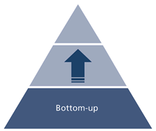
Planning an Enterprise GIS from the Bottom Up
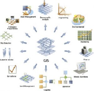
You might be an observant professional in a department that uses GIS. Your organization may be large and have many departments for which location is important. If that is the case, there is a strong possibility that those departments will approach you for certain services, e.g. cartography, location analysis, satellite imagery, spatial analysis, data processing, etc. In such a situation, it does not take a long time for you to realize the potential for using the GIS tools you have at your disposal for the rest of the company. Also, with time, you realize that there is a limit to the services you can perform on behalf of end-users in other departments and your real mission is to empower them to become capable of solving their own spatial problems using shared GIS tools.
This is usually the motivation of a bottom-up enterprise GIS undertaking. A top-down enterprise GIS initiative, by contrast is often initiated without regards to all the ground realities. There are many instances in which it turns out to be wasteful and unsuccessful in the end.
At this point, you should prepare a proposal of such a system, carefully documenting the application of spatial technologies for each of the other department that you provide services to. Most of this information, you would have gathered by patiently understanding and carrying out the GIS tasks of other departments. Thus your understanding is quite apt. Once it is in writing, you can ask your client in the associated department to elaborate on it.
Your proposal should detail this understanding and the name and designation of the contact person in each of the associated department. Make sure you highlight the benefits that GIS technology will provide the departments. This should lead to a section in the proposal that analysis the cost of doing business as usual compared with the benefits of using an enterprise GIS solution. Other parts of this proposal can cover the technical aspects needed to achieve the solution, including the software, hardware and data requirements. Mention of what implementation can be done in-house and what needs specialized contracting can also be noted.

This proposal should be an opportunity to get your line management to buy-in the idea of an enterprise GIS. Without management buy-in, there is no chance that such an endeavor can ever succeed. The proposal should be presented to the highest management with the backing of all your line management. If the idea is accepted, a GIS Champion should be established. This should be someone high in the organization’s management structure who passionately believes in an enterprise GIS. For an enterprise GIS to be successful you will need the GIS Champion to enforce compliance by other departments. The GIS Champion is also an excellent resource to represent your ideas at high-level managerial decision-making. It is through the help of the GIS Champion that bottom-up enterprise GIS can be implemented throughout the organization.

Once the project has been approved, you need to negotiate and write out the terms of responsibilities with all associated departments, most notably corporate IT. It often happens that different departments see their roles and methodology of implementation differently. Departments might compete for the same role. Thus, proper understanding through documentation is essential for everyone to work well together for the complete success of the whole organization.
Most enterprise GIS planning is dependent on the culture of an organization although there are some factors that are common to all organization. Someone working in a GIS department might think that they do not have the authority or ability to influence an enterprise GIS implementation positively throughout their organization. They should realize that they are in the best position to understand how GIS has the potential to be used on a day to day basis in their organization.
Their daily interaction with professionals using location analysis, makes them indispensable to make the right business case for the whole organization. If they have their management buy-in and a GIS Champion who thinks like them, they can be in a position to influence a successful implementation. Enterprise GIS involves many departments. Documenting their roles and responsibilities upfront avoids much confusion, frustration and lack of cooperation in the future leading to an enterprise GIS implementation that fulfills the expectation of all stakeholders.