
PriSUM Technologies Discusses the NJ DOT Project and How IMU Mapping Tools Reduce Damages

PriSUM Technologies believes in a proactive approach.
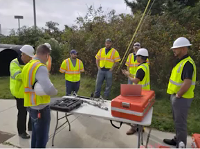
The last livestream presentation of SUMSF on March 23, 2022, was given by Santosh Saride, the VP of Strategy & Business Development for PRISUM Technologies, a division of Condux International. The presentation was on NJ DOT’s proactive approach to reducing underground utility damages using IMU mapping tools.
Saride discussed a CGA DIRT report showing how a third of utility damages were from locating practices. The main reason was locator errors, while other reasons were inaccurate information, incorrectly marked facilities, and abandoned lines. The consequences of these errors included project delays, cost overruns, and unsafe risks among others.
IMU has an autonomous nature of in-line mapping producing accurate digital as-built data. It’s valuable for the industry because it can be used when traditional locating technologies are unable to map inaccessible utilities.

Santosh Saride, the VP of Strategy & Business Development for PRISUM Technologies
Saride discussed the 3D mapping system. The benefits are endless. It can be used to map any underground utility pipeline, can map metal and plastic or HDPE pipes, there is no need for above-ground tracing, autonomous logging data, unlimited depth use (great for river crossings), accurate XYZ, and auditing reports, as well as seamless integration.
Saride discussed the NJ DOT’s project, estimated to cost around 320 million overall. A Smart Scoping Team (SST) was organized to minimize project risks and avoid critical infrastructure damages.
The goal of the project team was to minimize any need for relocations. The first step was field data collection, and the second step was the data processing and results.
PriSUM Technologies provide a precise mapping of underground assets in GIS platforms in any condition and are verified as-built installations. The technology gives accurate GIS data which is needed for augmented reality to underground utilities, increased project safety, and efficiency of installation.
An interesting Q and A session occurred after the livestream presentation. You can watch the entire presentation below on YouTube.
