
Project Manager – LIDAR Surveying
Today we had a chance to sit down with Ted MacKinnon, who has agreed to help us better explain and define what a Project Manager role with a LIDAR data Acquisition company is like and you could get yourself into the LIDAR survey business. A very exciting and dynamic role for young people to keep up to date with changing technology and also have a chance to see the world while getting paid to do it.
So welcome Mr. MacKinnon to Gogeomatics …
What organization do you work for? What is your title and how long have you been in that position?
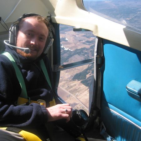
I am currently employed as a Project Manager with Terrapoint / Ambercore in Ottawa, Ontario. Terrapoint is a Geomatics company that provides LIDAR scanning services in both airborne and terrestrial environments, as well as other services. For the past four years I have been traveling all over North & Central America managing teams of professionals (including pilots, technicians, surveyors, system operators etc.) whom come together as a team to provide state of the art LIDAR data Acquisition for a variety of clients in various sectors.
What was your previous positions?
Previously I worked at PCI Geomatics in Richmond Hill, Ontario. PCI is a world renowned Remote Sensing Software company probably best known for their OrthoEngine & Geomatica software packages. I have also worked with other organizations such as the AGRG and Government departments (see my online resume for more details).
Where did you acquire your geomatics skills?
I got involved with Geomatics in 1997 at Acadia University and then followed it up by going to COGS in Nova Scotia to get an Advanced Remote Sensing Diploma to accompany my Bachelor of Science degree. I later returned to COGS a second time to take the Applied Geomatics Research program witch was dominantly LIDAR based.
Can you tell us what a typical day for you is like?
The majority of my work takes place in what we call the field (travel to where ever the work needs to be collected, typically not my home town), I am assigned a certain project and follow through managing that project from the hand off from the sales department right through to the hand off to the production and calibration team.
A typical day involves coordinating daily tasks of the crew (pilot(s), operator(s), ground crew – my crew has been as small as 2 and as large as 15) on the project, talking to clients, setting up GPS equipment, rough processing of data and then validating that data for quality analysis and control. Once the acquisition part of the project has been completed then I mobilize the team to another location to survey another area.
Project locations vary from as remote as the jungles of Nicaragua, the vast tundra in Nunavut and then back to more urbanized environments like the cities of Calgary, Ottawa, Houston, New York etc.
What’s the best thing about your job?
It is a great way to travel and see parts of the world that you would never get a chance to see other wise and get paid to see it at the same time.
And my boss is usually hundreds to thousands of miles away from me stuck in an office!
What skill set do you use the most in your job?
The most valuable skill in this position is “People Skills”, since I don’t hide in a cubical I need to be able to get along with a wide range of clientele and fellow employees during many long days in various environments. However with that said a solid technical knowledge and Geomatics skill set is important as well especially when working with a wide range of hardware, software and various geography.
Is there a skill set you looking at expanding or learning in the future?
As far as Geomatics related skills, I have a pretty good solid knowledge and am alwsy brushing up my skills as technology keeps evolving (with this type of job, i am always involved with the latest technologies). Off topic, my airborne experiences in helicopters and fixed wings have made me think of getting my own pilots license someday and I already have several hours flying aircrafts .
Is there a project that you’re particularly proud of that you can tell us about? Specifically what was your role and how did the project succeed?
There are several possible choices here but my graduate work at COGS dealing with 3D flood modeling of south eastern New Brunswick for Environment Canada still remains as the biggest project that I am proud of.
How do you feel about the future of our industry today?
Geomatics has evolved a lot even in the short time that I have been involved with it and as a Canadian I am proud to part of an Industry that Canada still leads in. We also have to thanks to some like Google for helping make more aware of Geomatics and even though software like Google Earth is no GIS software package it certainly has made it easier for non Geomatics users to get a better understanding of what we do.
Do you have any advice for someone interested in becoming a “Project Manager”?
If you have a passion for LIDAR, enjoy flying in small planes and helicopters, like to travel and work with a wide range of people then this could be the job for you.
Once again we would like to thank Mr. MacKinnon for taking the time to share with us information about LIDAR data Acquisition and we encourage you to go check out more about LIDAR his own website tmackinnon.com. If you would like to get involved in the LIDAR business then Mr. MacKinnon has offered to help provide you with some information and advice to point you in the right direction, simply check out his web site or let us know and we will put you in contact with him.
We would also remind you that Gogeomatics is your best place to help you build and network your own professional Geomatics career and encourage you to get involved in the discussions on the Gogeomatics Forum.
If you or someone you know is involved in Geomatics and would like to share your experiences with us then we would love for you to contact us.


I want to join your work. gis enginner , plz send me internship industrial research career prospects in Geospatial and remote sensing industry.