Special Geospatial Briefing June 13th: 1. Interactive Map Shares Indigenous Language, Arts and Culture 2. Native Land Digital 3. Treaty 6 territory in Alberta 4. First Nations Maps 5. Yellowhead Institute Red Paper 6. Indigenous Peoples Atlas of Canada 7. Story Maps Addressing First Nations Issues 8. Indigenous-owned Consulting
For National Indigenous History Month, we have brought you this special edition digest comprised of geospatial-related indigenous stories.
New interactive map shares Indigenous arts, language and culture throughout B.C.
The First Peoples’ Cultural Council has created this interactive map that displays indigenous language, arts, and heritage in British Columbia. According to the First Peoples’ map of B.C. there are over 200 indigenous communities in British Columbia who speak a total of 34 languages. The arts tab highlights many artists and their work, public art, events, and art organizations. The map also features over 300 cultural heritage places across the province.
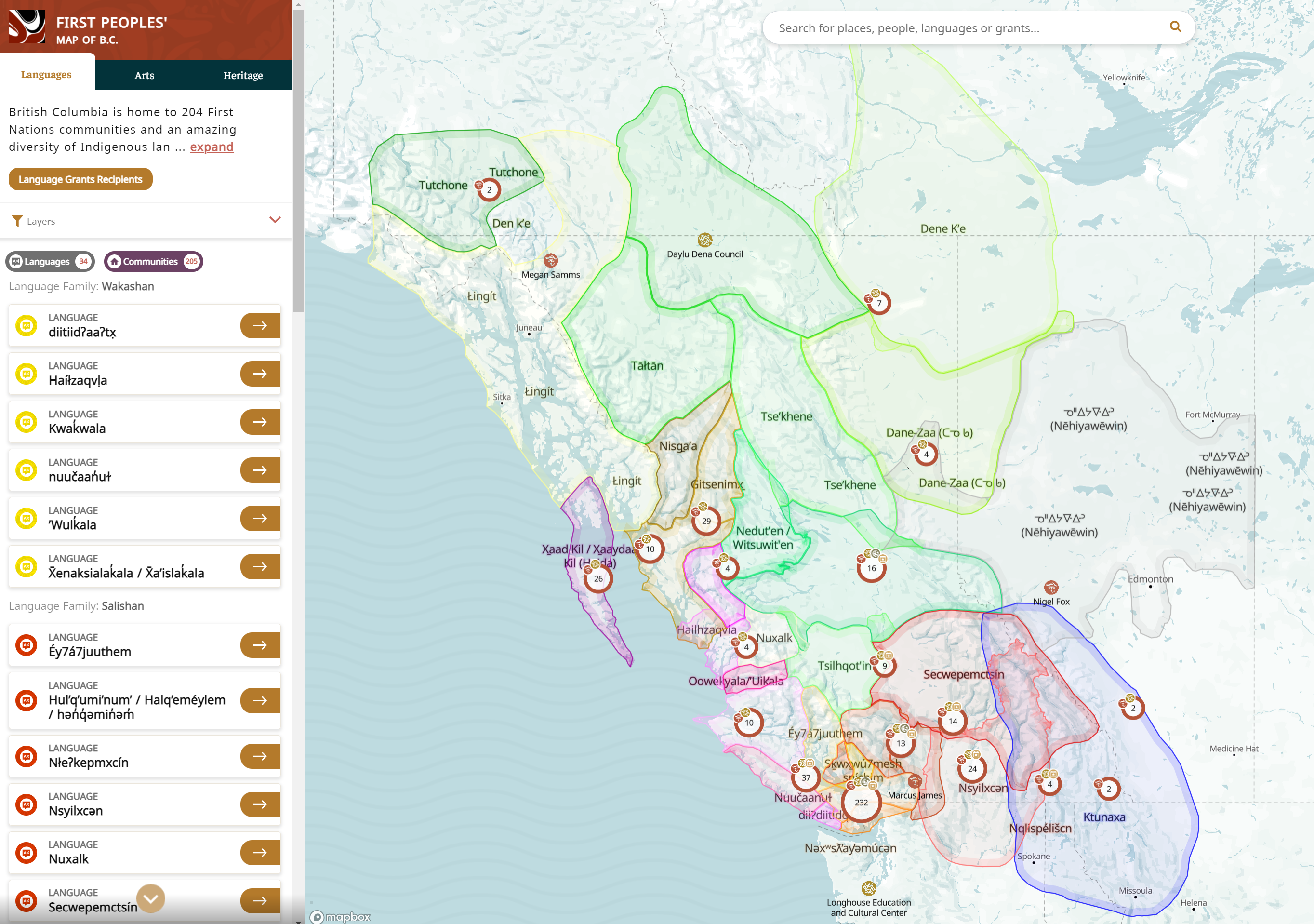
The First Peoples’ map of B.C.
Article can be viewed here
Native Land Digital
The Canadian organization, Native Land Digital is a not-for-profit indigenous-led organization that has created an interactive map displaying territories, languages, and treaties. This map allows you to explore many regions across the globe such as North and South America, Australia, New Zealand and parts of Europe, Africa, and Asia. The map does not use provincial, state, or country boundaries but displays the boundaries of many territories, shows what languages are spoken in which regions and shows the treaty locations in Canada, the United States and New Zealand. You can also enter your address into the map to learn more about each nation, language, or treaty in your location.
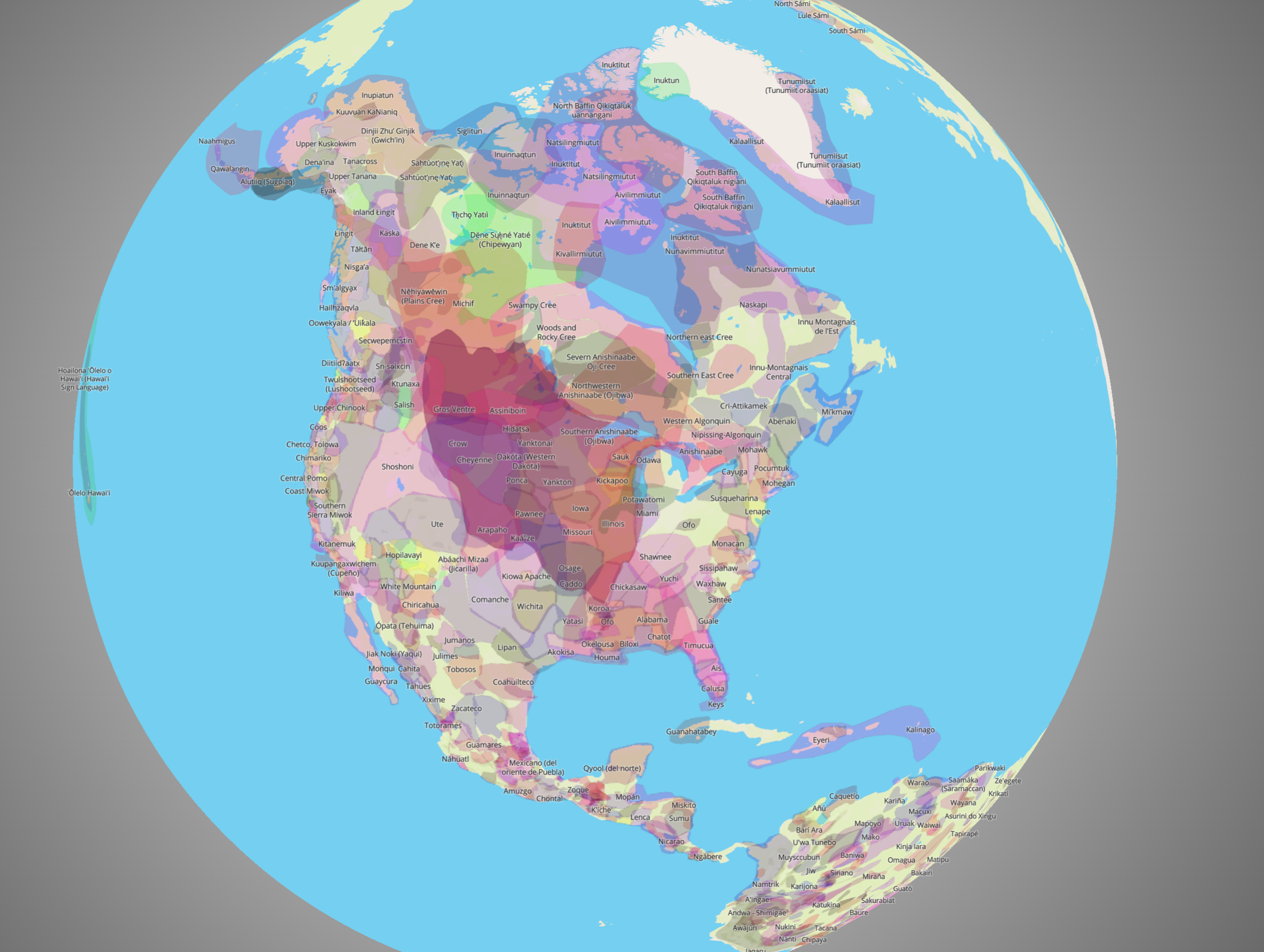
Native Land Digital interactive map
Map can be viewed here
Indigenous history on Treaty 6 territory in Alberta
In collaboration with indigenous community members and Elders, CBC Edmonton has created maps showing many points and their significance to learn more about indigenous history and culture on Treaty 6 territory. The maps show where and when Treaty 6 was signed and displays many points of art, educational institutions, places, First Nations, Métis Settlements, and community organizations. Each point has a description, and some will include photos and links where you can learn more.
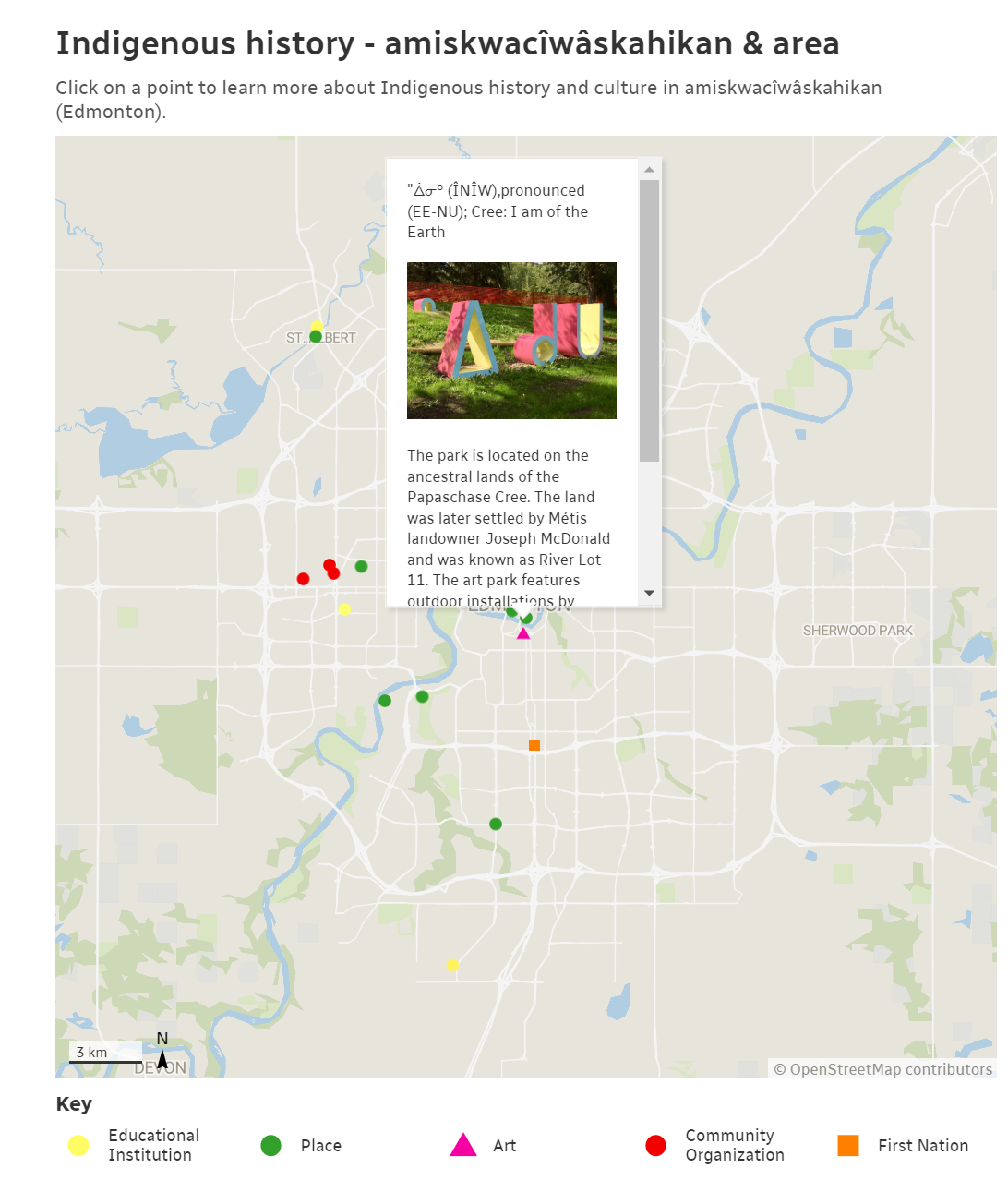
Map of Amiskwacîwâskahikan (Edmonton)
Article can be viewed here
First Nations Maps
Indigenous Peoples Resources has a collection of First Nations wall maps and posters for sale. They sell many maps in both English and French that cover North America, Canada, and many provinces.
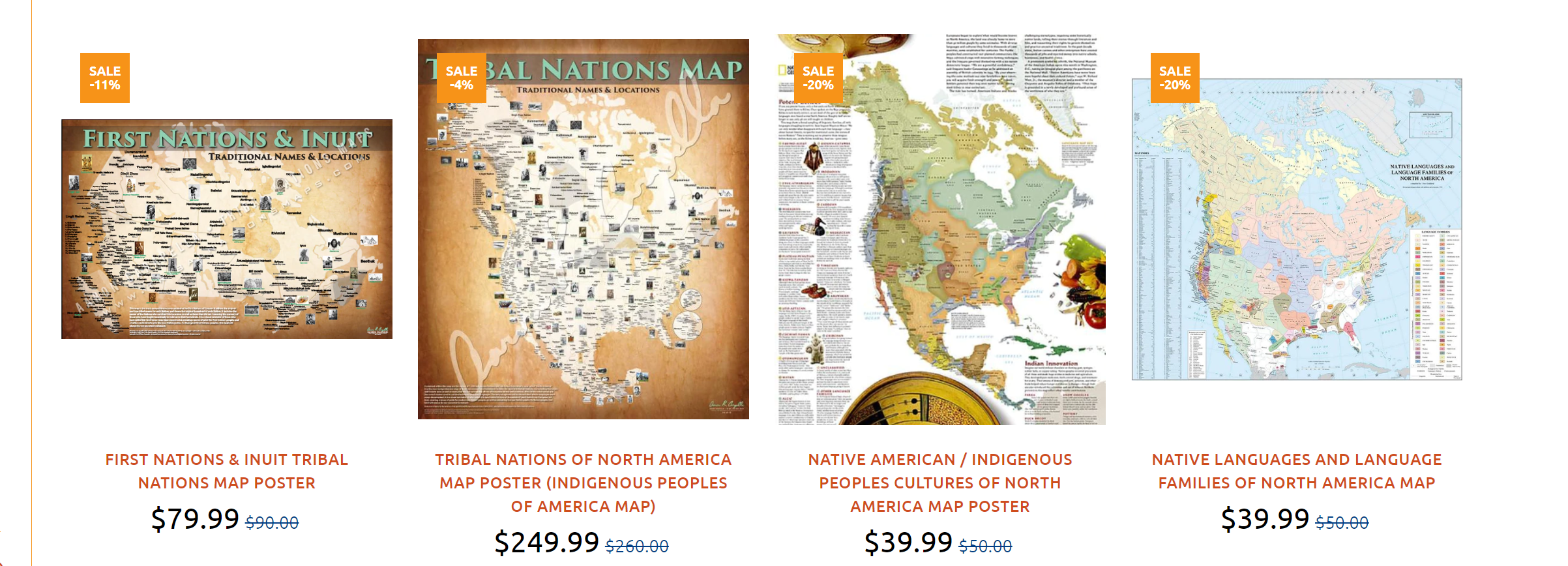
Indigenous Peoples Resources wall maps and posters
Maps can be viewed here
Yellowhead Institute Red Paper
The land back project was created by Yellowhead Institute and discusses the reclamation of indigenous territory. The project can be viewed in a full report that talks about how indigenous peoples were deprived of their land and how communities are working to reclaim that land. A piece of this project is the mine sweeper map which displays mining claims that have been connected to first nations communities in Quebec and Ontario.

The Yellowhead Institute’s Mine Sweeper Map
The report can be viewed here
Indigenous Peoples Atlas of Canada
With the release of the Indigenous Peoples Atlas of Canada, Dr. Adam Gaudry, a Métis assistant professor at the University of Alberta talks about the importance of re-mapping places to visualize a different space with indigenous existence. Dr. Gaudry discusses the first surveyors in the 1870s who entered the Canadian prairies that did not have consideration for indigenous territorial boundaries and landmarks. Dr. Gaudry mentions that map making can be a political process that often has indigenous places and territories left out or misrepresented.
Article can be viewed here
Story Maps Addressing First Nations Issues
We believe that traditional knowledge of Indigenous people around the world is invaluable and appreciate how story telling played an integral part of many cultures, passing knowledge from generation to generation. Finding new mediums to maintain this tradition of story-telling and knowledge sharing is a blessing of the technological age. We are thrilled to showcase some incredible story maps and interactive datasets that highlight some important issues for Indigenous groups around Canada and the world.
kNOwH2O
Created by students at the University of Calgary, the kNOwH2O story map addresses the UN’s Sustainable Development Goal #10: to reduce inequality within and between countries, as a part of the 2021 ESRI Canada GIS Centres of Excellence App Challenge. For many First Nations communities in Canada, one of the biggest injustices they face is a lack of access to clean, safe drinking water. Comparing data from 2016 (134 water advisories across Canada in 85 different First Nations communities) with 2021 (58 water advisories affecting 39 communities), the group set out to create the kNOwH2O Dashboard. This Story Map displays Boil Water Advisories, Boil Water Orders, and Do Not Consume statuses that are in effect for communities across Canada.
Story Map can be viewed here
The Water Crisis in Canada’s First Nations Communities
With problems as large as the lack of clean drinking water to First Nations communities, there are many advocates out there hoping to draw attention in search of a solution. Our second Story Map also addresses the long-term drinking water advisories in Canada’s First Nations communities. Created by Carina Xue Luo from the University of Windsor, this Story Map provides a thorough explanation of some of the major problems facing First Nations, while also covering what the government response has been, some of the real-world impacts the persisting issue has created, and suggests some steps moving forward that could be taken to address the problem.
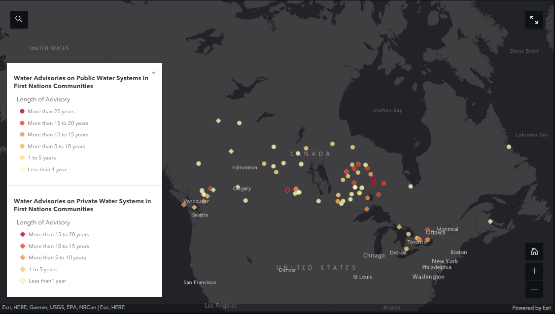
A map showing the length of time ongoing water advisories have affected First Nations communities across Canada.
Story Map can be viewed here.
Sea Gardens across the Pacific
While the above Story Maps draw attention to an important issue facing First Nations, our next featured Story Map celebrates and educates traditional Indigenous ways of ocean stewardship. Synthesizing information about mariculture traditions from communities all around the Pacific Ocean, this interactive Story Map from the Pacific Sea Garden Collective provides an education on the unique and creative ways different groups have stewarded the ocean for generations. Taking you on a journey from the Octopus Houses of Haida Gwaii to the Stone Tidal Weirs of Japan, this interesting and interactive Story Map celebrates some of the most unique and innovative practices from Indigenous communities around the pacific rim.
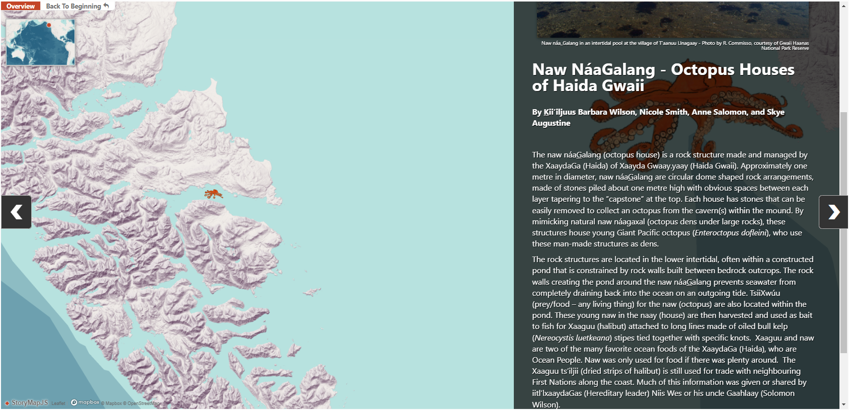
Pacific Sea Garden Collective. (2022). Sea Gardens Across the Pacific: Reawakening Ancestral Mariculture Innovations. Version 1. Washington Sea Grant at the University of Washington. https://doi.org/10.6069/ZJB9-CG30
Interactive story map can be viewed here
Indigenous-led Mapping and GIS Services
When it comes to land use mapping in traditional Indigenous territories, working with a team who understands the importance of traditional knowledge to the community is something that is not available with most mapping companies. The Firelight Group seeks to change that as “an Indigenous-owned consulting group that works with Indigenous and local communities in Canada and beyond to provide high quality research, policy, planning, mapping, negotiation, and advisory services.” They work with communities to ensure that they have the opportunity to control what is said or not said, as well as mapping the community knowledge of the land and its land use in culturally appropriate ways. While offering GIS and Mapping services, they also offer a wide variety of other services including Ecology, Indigenous Health, Indigenous Planning, and more. With offices in West Vancouver, Vancouver, Victoria, and Edmonton they hope to serve the rights and interests of Indigenous and local communities across Canada to help them achieve any and all goals.
To learn more about the Firelight Group, check out their website here