
2012

The “New” GoGeomatics Canada: Relaunching Our Magazine
A team of really intelligent squirrels and I have been working on the new GoGeomatics magazine. I’m taking a break…

A Canadian Geographer’s Notes from Nunavut
For the last five years, I have annually had the opportunity to spend time in Iqaluit, Canada’s fastest growing community in Canada’s fastest growing territory or province. On arrival, I check out the selection of new books at Arctic Ventures and the screening of new movies about the North. This year, there was the chance to see John Walker’s Passage and to buy a copy of Darrel Varga’s book of the same name in the Canadian Cinema series.

Google Earth Engine – What is a Data Cube and Why Canadians Should Care
What is a data cube and how is it used for big data analytics? How does a data cube work…

My COGS GIS Education, Part II
In my first article, I introduced the how and why I chose to attend COGS from the fall of 2014…

GIS in Action: How Does BC Pinot Noir Express Terroir?
Editors note: In this previously published article, Karl Kliparchuk, BCIT GIS Program Head & Instructor uses GIS to explore the…
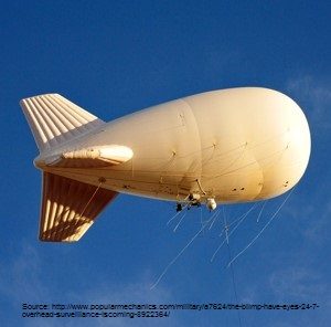
Geospatial Earth Observation Using Blimps, Balloons and Kites
These days drones are all the rage. Nevertheless, there are other ways to collect data from the sky! Blimps, balloons and kites…

Software Development – The Key to Ecere’s Success
It is rare to learn of a GIS company in which much R&D is done up front to create the…

Marine Geomatics Primer: Using UUVs to Take Flight Underwater
Unmanned Underwater Vehicles One of the most interesting things to happen in regards to marine geomatics technology has been the…
NB 911 Bureau Receives Esri Canada Award of Excellence in GIS
FREDERICTON, Esri Canada User Conference – October 25, 2016 – Esri Canada today presented the NB 911 Bureau, a branch…

Canadian Surveyors “Remark” on History with Elk Pass Boundary Restoration Survey
The Alberta-British Columbia Boundary Commission has just completed a monument restoration survey to restore a number of deteriorated provincial boundary…
Using Colour Transparency to Map Election Results
As the 2016 United States presidential election careens towards its conclusion in November, GIS plays a prominent role in both planning…
Canadian Institute of Geomatics Expands Executive Team with New VP Dr Brent Hall
Ottawa, August 16, 2016 – The Canadian Institute of Geomatics (CIG), the largest and most influential geospatial knowledge network in…
