
Acquisition

Elexicon Energy and Quantum Spatial Canada Pilot Comprehensive Mobile Mapping Project
Elexicon Energy (Elexicon) was formed in April 2019 by the merger of Veridian Connections and Whitby Hydro Electric Corporation. Owned…

Free Satellite Imagery For You: Sentinel 1 & 2
Sentinel constellations and data products As the ENVISAT program is coming to an end, the European Space Agency has begun…
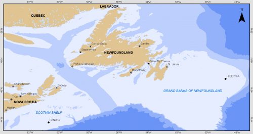
Grand Banks to the Gulf of Mexico: My Canadian Geomatics Career
I often contemplate what it would have been like working at the same job for an entire career. Mind you,…

Marine Geomatics Primer: Using UUVs to Take Flight Underwater
Unmanned Underwater Vehicles One of the most interesting things to happen in regards to marine geomatics technology has been the…

Geospatial Development: Enhancing GIS curricula with programming skills at UNB
Geospatial information science and technology (GIS&T) has rapidly evolved over the last few decades. This evolution has created a highly…

PCI Geomatics and PrecisionHawk Enter into Long Term Partnership
PCI Geomatics, a world leading developer of remote sensing and photogrammetric software and systems, announced today it has entered into…

Canadian GIS Ambassador Program: Interview with Brent Hall, Director of Education & Research at Esri Canada
Interview with Brent Hall, Director of Education and Research at Esri Canada and, along with his staff, the initiator of…
Airbus Defense And Space Signs Deal with Vancouver’s 3v Geomatics
Airbus Defense and Space and 3v Geomatics Inc. (3v Geomatics) signed a multi-year agreement that will provide 3v Geomatics with…
Teledyne to Acquire CARIS
Teledyne Technologies Incorporated (NYSE:TDY) (“Teledyne”) and CARIS jointly announced that the CARIS business and its international affiliates (collectively, “CARIS”) have…
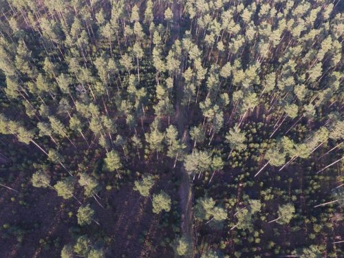
UAV Technology in the Canadian Forestry Sector
The Unmanned Aerial Vehicle (UAV) industry is soaring! Civilian drones are being applied in various global industries ranging from agriculture…
An API for the World’s Weather & Climate Data
Planet OS is excited to announce the launch of our first API designed specifically for geospatial and Earth observation data.…
Kongsberg Gallium becomes Kongsberg Geospatial
The move is part of a comprehensive rebranding strategy to more effectively align the Company’s name with its future strategy…
