
airborne

Discover ITRES at the GoGeomatics Expo
We are thrilled to announce that ITRES is exhibiting at the GoGeomatics Expo, Nov 6-8th in Calgary. ITRES (1979) is…
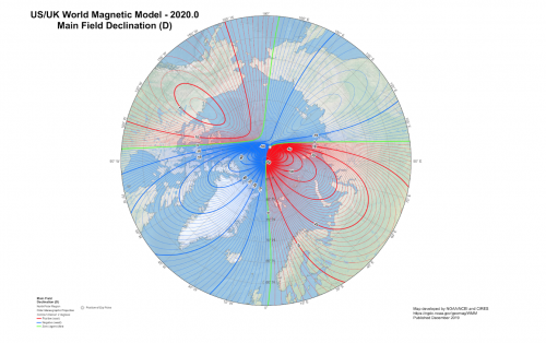
Geomagnetic field is a reliable tool for navigation and mapping applications
Our Earth is surrounded by its magnetic field that extends from the planet’s core to the outer space. It is…
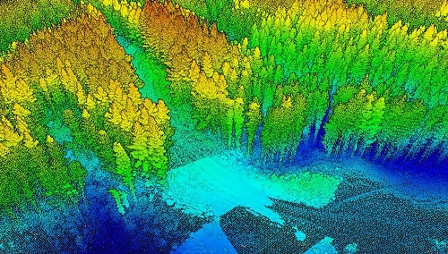
A Japanese Perspective: LiDAR forest data for resource analysis in Japan
The GIS & LiDAR Specialist I am Kei, a passionate GIS & LiDAR Specialist with over 6 years’ experience in…

Old Cities, New Discoveries: How LiDAR is changing Archeological Surveys
LiDAR (Light Detection and Ranging) is not a new technology; it has been around since the early 1960’s when a…

Elexicon Energy and Quantum Spatial Canada Pilot Comprehensive Mobile Mapping Project
Elexicon Energy (Elexicon) was formed in April 2019 by the merger of Veridian Connections and Whitby Hydro Electric Corporation. Owned…

Event Recap: COGS & CIG & GANS Cooperate for Mapping Workshop
The Canadian Institute of Geomatics (CIG) Nova Scotia Branch and the Geomatics Association of Nova Scotia (GANS), two regional professional organizations that foster the application of geographic information within the geomatics sector recently collaborated to host a high resolution mapping workshop at the Centre of Geographic Sciences (COGS) in Lawrencetown, Nova Scotia.

Atlantic Canada: COGS: Geomatics Professionals Coming to Discuss High Resolution Coastal Mapping
High Resolution Coastal Zone Mapping This collaborative effort by GANS & the CIG will engage the geospatial community & increase awareness on the value…

Feb 7-8: Two Day Workshop on High Resolution Mapping Along Coastal Zones
The coastal zone, that dynamic geographic region where the interaction of the sea and land occurs, is vital to the…

UAVs in Canada – Key Exposures to Loss and Ways to Protect Yourself
This article was written by Mark Sampson for the Association of Ontario Land Surveyors. Mark’s contact details are at the…
The Canadian Institute of Geomatics (CIG) New President: Rodolphe Devillers
The Canadian Institute of Geomatics (CIG) is pleased to announce its new President, Rodolphe Devillers, PhD, Professor in Geography at…
Geoscience BC Launches Largest Airborne Magnetic Survey in its History
Vancouver, BC — Geoscience BC announced the launch of its largest airborne magnetic survey to date — the Search Phase…
Keystone Aerial Surveys, Inc. optimizes efficiency with Optech Galaxy
Teledyne Optech is pleased to announce that Keystone Aerial Surveys, Inc. has accepted delivery of the most capable airborne lidar…
