
CAD

GNOSIS – A New Geomatics Software Suite
Creating a new GIS from scratch is a tough undertaking. It involves a lot of innovation. Ecere, a Canadian company…

Tim Webster: Interview about Past, Present, & Future: Applied Geomatics Research Group
Dr. Tim Webster, is a renowned research scientist with the Applied Geomatics Research Group (AGRG) in Middleton, Nova Scotia. He is…

Event Recap: COGS & CIG & GANS Cooperate for Mapping Workshop
The Canadian Institute of Geomatics (CIG) Nova Scotia Branch and the Geomatics Association of Nova Scotia (GANS), two regional professional organizations that foster the application of geographic information within the geomatics sector recently collaborated to host a high resolution mapping workshop at the Centre of Geographic Sciences (COGS) in Lawrencetown, Nova Scotia.

UBC Unveils New Masters of Geomatics for Environmental Management
The UBC Faculty of Forestry is excited to announce that the official approval of the Master of Geomatics for Environmental Management…

Interview with Sam Scovill, GIS Technician and 3 Day Champion on Jeopardy
Every weeknight, my mom and I watch Jeopardy together. Jeopardy always starts with the announcement of the contestants by their…

Edmonton GoGeomatics Bowling Night Social February 16
Thursday, February 16, 2017 7:00 PM to 10:00 PM Ed’s Rec Room WEM, Edmonton , AB At the West Edmonton…
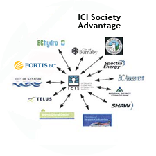
The Integrated Cadastral Information (ICI) Society and ParcelMap BC
This is the first of two articles on the release of ParcelMap BC Data, which we see as a significant…
Canadian Geomatics Innovation: Ecere Develops a Next Generation GIS
Not many companies undertake the ambitious goal of creating a new geospatial software suite from scratch. Ecere, a Canadian company…

March 23 Career Fair: Centre of Geographic Sciences (COGS) Industry Expo
It’s that time of year again where geomatics students in Canada are starting their final semesters of school, many are…

Feb 7-8: Two Day Workshop on High Resolution Mapping Along Coastal Zones
The coastal zone, that dynamic geographic region where the interaction of the sea and land occurs, is vital to the…

Interview with Ted Mackinnon: Promoting Canadian GIS & Geomatics on Twitter
GoGeomatics has been actively using Twitter to reach out to the geospatial community since 2009. We have written and hosted…

List of Canadian Geomatics Conferences and Events for 2017
This is our list Canadian geomatics conferences and events for 2017. Here you will find events pertaining to GIS, remote…
