
Climate Change
The Federal Government of Canada Geospatial Director’s Panel at GeoIgnite 2022
During the WinterGeo summit this past March, a collection of some of the most prominent names in Canadian Geospatial sciences…

Panelists Discuss The Power of Diversity When Combating Climate Change
Five Views On The Importance of Diverse Perspectives During the GeoIgnite, Winter Geo live-streamed closing panel discussion on March 3,…

Canadian Geospatial Briefing July 4th: 1. Carbon soil mapping 2. MDA and NGO for combating illegal fishing 3. Indigenous mapping workshop 4. Deadly Skin Cancer map 5. Mapping Bicyclists’ Greatest Dangers
Carbon soil mapping project aims to help beef producers trap carbon, fight climate change “Our grassland soils hold large amounts…
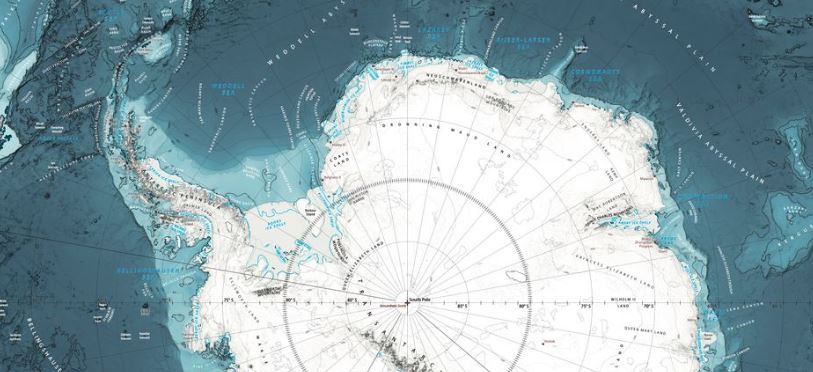
International Geospatial Briefing June 27th: 1. Deepest Point of Antarctica’s Southern Ocean Mapped; 2. Digital Twin of Denmark’s Transmission Network; 3. Map Compares the World’s Mountains and Rivers; 4. How Geospatial can be Applied to Climate Challenges; 5. When Digital Tools Fail to Document; 6. Shifting from Response to Recovery
1. Deepest Point of Antarctica’s Southern Ocean Mapped The deepest point of the Southern Ocean surrounding Antarctica – a 7,432-meter…
OGC Discusses The 2021 Disaster Pilot And What’s To Come
Plans To Improve Disaster Decision Making By Developing Standards-Based Services Open Geospatial Consortium (OGC) Senior Director, Trevor Taylor, spoke regarding…
LIKE ME Conference Addresses Climate Change at First Virtual Conference
Industry experts and academia addressed climate change using geolocation intelligence at this year’s LIKE ME (Like Mother Earth) Conference. It…

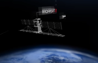
CHORUS Constellation Evolutionalizes How We Understand Climate Change
“CHORUS will evolve our understanding of climate change” CHORUS, MDA’s commercial Earth observation mission and a collaborative multi-sensor constellation, is…

Sparkgeo Uses a Geospatial Lens to Look at Earth’s Issues on a Planetary Scale
Cadell Asks Us To Rescale Our Way of Thinking The keynote speaker for GeoIgnite, Winter Geo conference on March 2,…
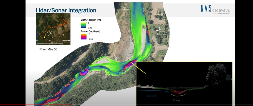
NV5 Geospatial Discusses Remote Sensing and Analytics to Support Hydrospatial Solutions
A “Holistic Understanding of Water in Our World” At the March 1, 2022, GeoIgnite, Winter Geo conference, Sven Cowan, Canada Program…

Canadian Geospatial Briefing May 30th: 1. GHGSat Joins ESA’s Third Party Mission Programme, 2. Time Traveller Interactive Tool, 3. BC Climate Change Vulnerability Map, 4. Mississauga’s Photo Radar Speed Camera Locations
GHGSat Joins ESA’s Third Party Mission Programme Methane may not be as abundant in the atmosphere as carbon dioxide, but…

Deploy Software Solutions Fills in the Communication Gap When Needed Most
Improving Communication Between Citizens and Authorities During Disasters During GeoIgnite, Winter Geo livestream on March 2, 2022, Nick Kellet, Founder…

Moving the Climate Narrative Beyond the “doom and gloom” Keith Masback and Dr. Marshal Shepherd
“Climate is science.” The way we discuss climate change is evolving. The GeoIgnite, Winter Geo Conference, was honoured to have…
