
Collection

Easy Access to Data: The CGDI Initiative
The Canadian Geospatial Data Infrastructure (CGDI) is an initiative of Natural Resources Canada that began in 2001. The CGDI does…

Operational GIS Jobs in the Canadian Military
Whether its businesses, governments or for personal use, Geomatics offers everyday solutions to the worlds questions. The Canadian Armed Forces…
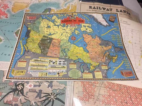
Canadian Cartography: GoGeomatics Edmonton Visits the University of Alberta Map Library & Collections
Last night the Edmonton GoGeomatics Group had the chance to explore the amazing collection of historic maps at the University…

PCI Geomatics and PrecisionHawk Enter into Long Term Partnership
PCI Geomatics, a world leading developer of remote sensing and photogrammetric software and systems, announced today it has entered into…

Volunteer & Map Canada: Statistics Canada Crowdsourcing Pilot Project
Statistics Canada has launched a new pilot project using OpenStreetmap. For many Canadians outside of the geomatics community this is…
Airobotics Selects SimActive’s Photogrammetry Software for its Automated Industrial Drone Solution
Montreal, Canada, August 30th, 2016 – SimActive Inc., a world-leading developer of photogrammetry software, is pleased to announce that Airobotics…
MDA signs contracts for RADARSAT-2 information
Richmond, BC – MacDonald, Dettwiler and Associates Ltd. (“MDA” or the “Company”) (TSX: MDA), a global communications and information company,…
New Canadian GoGeomatics Group Launched in Peterborough Ontario
GoGeomatics Canada would like to announce Peterborough, Ontario has been added to our growing list of cross-country GoGeomatics Socials! We…
Countdown to Launch: DigitalGlobe’s WorldView-4 Earth Imaging Satellite
Final preparations are underway at Lockheed Martin to ship DigitalGlobe’s WorldView-4 earth imaging satellite to Vandenberg Air Force Base for…
Keystone Aerial Surveys, Inc. optimizes efficiency with Optech Galaxy
Teledyne Optech is pleased to announce that Keystone Aerial Surveys, Inc. has accepted delivery of the most capable airborne lidar…
Conversations with Michael Goodchild on Questions of Geography
Recently, I had the opportunity to sit down with Michael Goodchild and talk about his book and Geography. Michael was…
Global GIS Market to Grow Steadily at a CAGR of More Than 10% by 2020
Technavios market research analyst predicts the global GIS market to grow steadily at a CAGR of more than 10% by…
