
data analysis

International Geospatial Digest November 6, 2023
Prague: a fitting setting for a mobile mapping innovation New Tool Helps Solve Geospatial Imaging Challenges An Extremely Detailed Guide…

Panelists Discuss Using Geointelligence and AI to Solve Real World Problems
Maxar Sponsors Panel Discussion at GeoIgnite, Winter Geo During a livestream at the GeoIgnite, Winter Geo conference on March 1,…
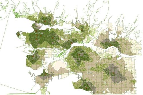
Using GIS to study health care services and utilization––from local to national
Access to timely and quality health care is an important determinant of health and well-being. Despite universal health coverage in…

UBC Unveils New Masters of Geomatics for Environmental Management
The UBC Faculty of Forestry is excited to announce that the official approval of the Master of Geomatics for Environmental Management…
The Integrated Cadastral Information (ICI) Society and ParcelMap BC
This is the first of two articles on the release of ParcelMap BC Data, which we see as a significant…
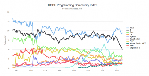
What are the Top Programming Languages in the GIS World?
Image source: www.tiobe.com Every now and again we hear about the importance of programming for Geographic Information Systems(GIS) professionals, that…

It’s a Geospatial world we live in: Find Your Happy Place
When does a space become a place? There are a myriad of small open spaces and buildings throughout towns and…

University of Victoria Hosts Advanced Spatial Analysis Course
Is neighbourhood socioeconomic status associated with pediatric and childhood injuries? Are such injuries clustered in space? How can I model…

Professional Certification: Population Health Data Analysis in British Columbia
Population health research is inherently interdisciplinary, multifaceted and firmly rooted in the evolving connections between place, time and related socioeconomic…
PCI Geomatics User Group Meeting Shows Promising New Features and Dedication to Customers
On February 4th, PCI Geomatics held their Annual User Group Meeting in Ottawa, Ontario. There was a high turnout, with…
SimActive Announces Correlator3DTM Version 6.2
Montreal, Canada, September 1st, 2015 – SimActive Inc., a world-leading developer of photogrammetry software, is pleased to announce Correlator3D™ version…
University of Waterloo Students Win the Esri Canada GIS Centres of Excellence App Challenge
PredictION helps citizens understand the impact of proposed transit changes to their daily commute TORONTO – Esri Canada congratulates Jonathan…
