
datasets
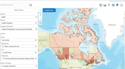
What is the Canadian Statistical Geospatial Explorer?
Statistics Canada produces statistics that help Canadians better understand their country. The agency ensures Canadians have the key information on…

Your Canadian Geospatial Briefing for June 15th: Canadian Drone delivery solution; City of Montreal open data; Tagged leatherback sea turtles; Endangered Fish in BC
Drone company will convey COVID-19 medical equipment to First Nation Drone Delivery Canada (DDC) will transport COVID-19 medical products using…

Google Earth Engine – What is a Data Cube and Why Canadians Should Care
What is a data cube and how is it used for big data analytics? How does a data cube work…

Top Ten Climate Change Maps and GIS Applications
Awareness for climate change has been steadily increasing ever since the Green Revolution in the 1960s. There is a plethora…
The Integrated Cadastral Information (ICI) Society and ParcelMap BC
This is the first of two articles on the release of ParcelMap BC Data, which we see as a significant…

The 5 most interesting things that happened in geomatics in 2016
Let’s take a step back and have a look at what happened this year. To be honest, it was pretty…
Exploring GIS Day at the Glenbow Museum, Calgary.
I had the opportunity to celebrate GIS Day by attending the event hosted by the Alberta Geomatics Group at the…

A List of Geospatial Open Data Resources in Canada
Recently, I read an article about the Canadian Geospatial Data Infrastructure (CGDI) that seeks to explain why the CGDI, among many…

what3words adopted by six national mapping agencies
what3words, the multi-award winning location reference system, has today announced that six national mapping agencies have adopted 3-word addresses. Used…

New Brunswick: CARIS Announces release of HIPS and SIPS™ 10
Fredericton, NB, Canada – November 01, 2016 – Teledyne CARIS™ is pleased to announce the release of HIPS and SIPS™ 10.…

QGIS & WorldClim: Using Zonal Statistics to Map Temperature Patterns
There has never been a time in the history of GIS when so much free, high quality data has been…
NB 911 Bureau Receives Esri Canada Award of Excellence in GIS
FREDERICTON, Esri Canada User Conference – October 25, 2016 – Esri Canada today presented the NB 911 Bureau, a branch…
