
EMS
Nominations for GIS Science Award: GIScience Study Group CAG – ACG
GIScience Excellence Award Offered and adjudicated by the GIScience Study Group Annual nominations are due by midnight of 15 April…

My COGS GIS Education
What About COGS The Centre of Geographic Sciences (COGS) is one of the best colleges in Canada for learning GIS. …
MDA to Acquire DigitalGlobe, Creating Industry Leader in End-to-End Space Systems, Earth Imagery and Geospatial Solutions
San Francisco and Westminster, Colo. – MacDonald, Dettwiler and Associates Ltd., a global communications and information company providing technology solutions…

Top Ten Climate Change Maps and GIS Applications
Awareness for climate change has been steadily increasing ever since the Green Revolution in the 1960s. There is a plethora…
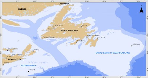
Grand Banks to the Gulf of Mexico: My Canadian Geomatics Career
I often contemplate what it would have been like working at the same job for an entire career. Mind you,…

GNOSIS – A New Geomatics Software Suite
Creating a new GIS from scratch is a tough undertaking. It involves a lot of innovation. Ecere, a Canadian company…

Montreal: K2 Geospatial launches latest version map-based integration platform JMap
More powerful, even more robust and interoperable, JMap 7 is now available JMap’s 7th version is finally here! K2 Geospatial,…
TECTERRA Board Names Jonathan Neufeld as Next CEO
February 14, 2017 (Calgary, Alberta) – TECTERRA announced the appointment of Mr. Jonathan Neufeld as the Chief Executive Officer. Neufeld…

Event Recap: COGS & CIG & GANS Cooperate for Mapping Workshop
The Canadian Institute of Geomatics (CIG) Nova Scotia Branch and the Geomatics Association of Nova Scotia (GANS), two regional professional organizations that foster the application of geographic information within the geomatics sector recently collaborated to host a high resolution mapping workshop at the Centre of Geographic Sciences (COGS) in Lawrencetown, Nova Scotia.
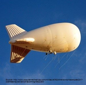
Geospatial Earth Observation Using Blimps, Balloons and Kites
These days drones are all the rage. Nevertheless, there are other ways to collect data from the sky! Blimps, balloons and kites…

New Galileo navigation system is experiencing clock failures
Since December 15, 2016, the new Galileo global satellite navigation system has been up and running. Unfortunately, there are…

Software Development – The Key to Ecere’s Success
It is rare to learn of a GIS company in which much R&D is done up front to create the…
