
flooding
Geospatial Digest for Earth Day April 22nd, 2024
Water Pollution in Ireland Esri Ireland has teamed up with the Dublin Urban Rivers LIFE (DURL) Project to tackle water…

Canadian Geospatial Digest for March 25th, 2024
How Indigenous companies are bringing high-tech solutions to the forest sector GIS in Mining: Strengthening Indigenous Communities Flood risk mapping…
Canadian Geospatial Digest November 27, 2023
Mapping the Semá:th X̱ó:tsa (Sumas Lake) after 2021 BC Floods. Mapping the health of Canada’s lakes. Canadian Geospatial Startups Revolutionizing…

Research & Education: Tim Webster on Applied Geomatics Research Group (AGRG)
The AGRG, Applied Geomatics Research Group, was formally founded in 2000 by COGS (College of Geographic Sciences) faculty members who…
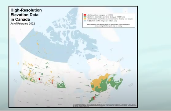
NRCAN Leading Initiative to Increase Canada’s Resilience to Flooding
Geomatic Services Playing Key Role in Initiative On March 1, 2022, Brian Perry, Engineering Advisor for flood modeling with Natural…

Canadian Geospatial Briefing March 7th: 1. MDA to Build 17 satellites to Enhance Globalstar’s LEO Constellation. 2. DDC’s new management. 3. DDC’s update on Canary drone testing. 4. Need for RADARSAT in disasters. 5. Cape Breton Highlands image looks like a kitty.
MDA to Build 17 Satellites to Enhance Globalstar’s LEO Constellation According to MDA’s announcement on Feb 24th, this company is…
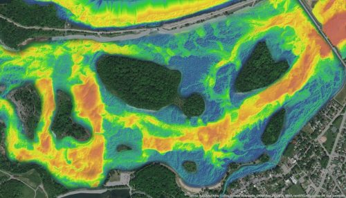
NV5 Geospatial Supports Flood Risk Mapping in Montreal Through Canada’s Largest Riverine Topobathymetric Lidar Survey
The Greater Montréal Area completed Canada’s largest-ever riverine topobathymetric lidar survey inresponse to two major flooding events within the last…
