
globe
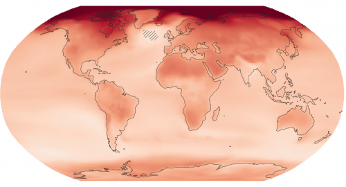
New interactive atlas paints a picture of how climate change will impact the globe and what this means for Canada
The latest Intergovernmental Panel on Climate Change (IPCC) sixth assessment report warns about the future of our planet under the…

Mystery Speaker Revealed for Next Ottawa GoGeomatics Social April 25th
GoGeomatics has swept aside the curtain to reveal Masroor Hussain, Senior Scientist and Software Developer at PCI Geomatics, as the…
MDA to Acquire DigitalGlobe, Creating Industry Leader in End-to-End Space Systems, Earth Imagery and Geospatial Solutions
San Francisco and Westminster, Colo. – MacDonald, Dettwiler and Associates Ltd., a global communications and information company providing technology solutions…

Top Ten Climate Change Maps and GIS Applications
Awareness for climate change has been steadily increasing ever since the Green Revolution in the 1960s. There is a plethora…

GNOSIS – A New Geomatics Software Suite
Creating a new GIS from scratch is a tough undertaking. It involves a lot of innovation. Ecere, a Canadian company…

Event Recap: COGS & CIG & GANS Cooperate for Mapping Workshop
The Canadian Institute of Geomatics (CIG) Nova Scotia Branch and the Geomatics Association of Nova Scotia (GANS), two regional professional organizations that foster the application of geographic information within the geomatics sector recently collaborated to host a high resolution mapping workshop at the Centre of Geographic Sciences (COGS) in Lawrencetown, Nova Scotia.

Atlantic Canada: COGS: Geomatics Professionals Coming to Discuss High Resolution Coastal Mapping
High Resolution Coastal Zone Mapping This collaborative effort by GANS & the CIG will engage the geospatial community & increase awareness on the value…
Canadian Geomatics Innovation: Ecere Develops a Next Generation GIS
Not many companies undertake the ambitious goal of creating a new geospatial software suite from scratch. Ecere, a Canadian company…

Feb 7-8: Two Day Workshop on High Resolution Mapping Along Coastal Zones
The coastal zone, that dynamic geographic region where the interaction of the sea and land occurs, is vital to the…

December 14th is the Ottawa CRSS GoGeomatics Christmas Party
Get your sleighbells jingling for the CRSS GoGeomatics Christmas Party! For the fourth year in a row, we’re teaming up…
Report for 450 Participants & Sponsors: 2016 GoGeomatics Canada Back to School Socials
Last month the Canadian geomatics community came together to celebrate the start of the new school year by welcoming new…

DigitalGlobe’s Basemap Suite Expands: 250 Million Square Kilometers of 30 cm Imagery
DigitalGlobe, Inc. (NYSE: DGI), the global leader in Earth imagery and information about our changing planet, today announced that its…
