
Habitat Protection
Canadian Geospatial Briefing May 10th: Developing Tools to Protect Canada’s Biodiversity; Tracking impact of industrial projects on B.C. species at risk; 3D satellite mapping shows that glaciers are melting faster than ever; Geospatial Maturity Index shows that Calgary is a leader in GIS programs; Community engagement to measure impact of climate change on coastal environments in the Estuary and Gulf of St Lawrence; Surprising locations in Canada that have seen the largest increase in house prices
Carleton and Partners Developing Tools to Protect Canada’s Biodiversity Dr. Joseph Bennett, a biology professor at Carleton University and his…
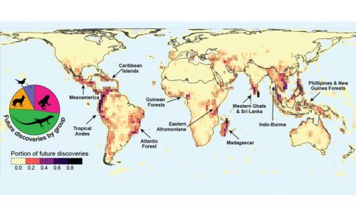
International Geospatial Briefing April 19th: Wyoming Mapping Project Helps Identify Important Habitats; Map of the Mafia Gives Deeper Insights into Former Operations; Animated Map Shows History of Earthquakes and Tsunamis Around the World; OGC API Allows Vector Data Transmission in Any Coordinate Reference System; Interactive Map Could Help Scientists Discover Previously Unknown Species
New Wyoming Mapping Project Helps Identify Important Habitats for Protection A new mapping project by the Wyoming Game and Fish…
