
Interactive Atlas

Canadian Geospatial Briefing March 21st: 1. Developing a subsurface digital twin for Canada. 2. Putting Indigenous knowledge on the map. 3. Mapping all flood prone areas in the Yukon. 4. Environmental impact of trucker protest. 5. Using AI to measure urban sprawl in Canada.
The Virtual Subsurface Utility Mapping Strategy Forum Conference 2022 presents a panel on developing a subsurface digital twin for Canada…
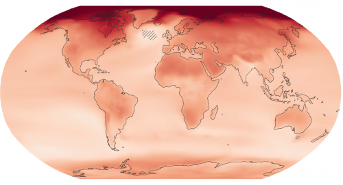
New interactive atlas paints a picture of how climate change will impact the globe and what this means for Canada
The latest Intergovernmental Panel on Climate Change (IPCC) sixth assessment report warns about the future of our planet under the…
