
journal
Geospatial Earth Observation Using Blimps, Balloons and Kites
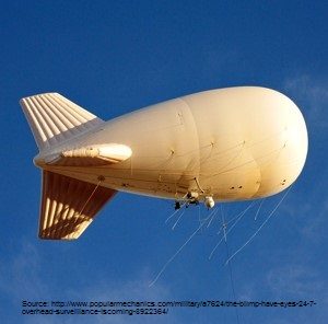
These days drones are all the rage. Nevertheless, there are other ways to collect data from the sky! Blimps, balloons and kites…

Geospatial Development: Enhancing GIS curricula with programming skills at UNB
Geospatial information science and technology (GIS&T) has rapidly evolved over the last few decades. This evolution has created a highly…
Drone World Expo Conference Program Will Provide a Road Map for Commercial Drone Solutions
A world-class conference program and several new educational and networking features will take place at the 2nd annual Drone World…
Global GIS Market to Grow Steadily at a CAGR of More Than 10% by 2020
Technavios market research analyst predicts the global GIS market to grow steadily at a CAGR of more than 10% by…
Canadian Government Supports Advanced Geomatics Research
Leading Edge Geomatics will be able to develop new and advanced airborne mapping technology thanks to a repayable government contribution…
GIS Certification: The Canadian Institute of Geomatics Certification Program
One of the GIS Certifications available to Canadians specifically is the Certified Geomatics Specialist certification available from the Canadian Institute…
GIS Certification: ASPRS Certification
One type of certification available for GIS and Geomatics professionals is the ASPRS Certification program available from the American…
FAA Task Force recommends registration for drones over 9 ounces
A Federal Aviation Administration task force has recommended requiring owners of all drones larger than 9 oz. (250 grams) to…
Open Source GIS for Everyone: A QGIS-based program at Langara College Vancouver
This article is the first in a monthly GoGeomatics Canada series on topics related to Open Source GIS for Everyone,…
New Online Publication: Drone Coalition
An exciting new online publication, Drone Coalition, launched in conjunction with the InterDrone 2015 Conference and Exposition in Las Vegas,…
New Book: Web Mapping and Geospatial Web Services
It is with great pleasure that I want to introduce a new Web Mapping and Geospatial textbook to the Canadian geomatics…
TECTERRA Funds Additional $4.8 Million for Geomatics Growth in 2014-15
CALGARY, ALBERTA – TECTERRA Inc. announced that it has committed $4.8 million of funds to support the geomatics technology sector…
