
Mapbox

Top 6 Reasons to Attend GeoIgnite 2020: Canada’s National Geospatial Event
The Geoignite 2020 conference program spotlights the technology sector’s influential leaders as partners and speakers, shares insights on the intersection…

Mapbox and Sparkgeo Announce Web Map Analytics Integration
Mapbox and Sparkgeo today announced a new integration of Sparkgeo’s web map analytics technology, Maptiks, with Mapbox GL web maps.…

Mapbox joins GeoIgnite 2019 as Platinum Sponsor
GeoIgnite 2019 has a new platinum sponsor! Mapbox joins leaders from technology, government and academia in discussing the current and…

Top Ten Climate Change Maps and GIS Applications
Awareness for climate change has been steadily increasing ever since the Green Revolution in the 1960s. There is a plethora…
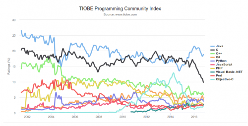
What are the Top Programming Languages in the GIS World?
Image source: www.tiobe.com Every now and again we hear about the importance of programming for Geographic Information Systems(GIS) professionals, that…
DigitalGlobe Expands Partnership with Mapbox to Provide Access to 30 cm Imagery Basemaps
DigitalGlobe, Inc. (NYSE: DGI), a leading global provider of commercial high-resolution earth observation and advanced geospatial solutions, today announced an…
