
mining
Airobotics Selects SimActive’s Photogrammetry Software for its Automated Industrial Drone Solution
Montreal, Canada, August 30th, 2016 – SimActive Inc., a world-leading developer of photogrammetry software, is pleased to announce that Airobotics…
Jessi Mielke Esri’s Certification Manager Chats About the Esri Technical Certification Program
For the last 6 months I’ve been writing articles and discussing my experience in regards to the Esri technical certification…
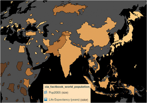
Using Colour Transparency to Map Election Results
As the 2016 United States presidential election careens towards its conclusion in November, GIS plays a prominent role in both planning…
Government of Yukon Wins 2016 Esri Special Achievement in GIS Award
SAN DIEGO, Esri User Conference—June 29, 2016—Esri Canada congratulates the Government of Yukon for receiving the 2016 Esri Special Achievement…
Airbus Defense And Space Signs Deal with Vancouver’s 3v Geomatics
Airbus Defense and Space and 3v Geomatics Inc. (3v Geomatics) signed a multi-year agreement that will provide 3v Geomatics with…
Drone World Expo Conference Program Will Provide a Road Map for Commercial Drone Solutions
A world-class conference program and several new educational and networking features will take place at the 2nd annual Drone World…
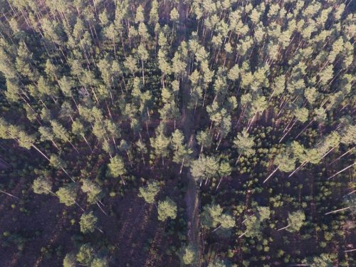
UAV Technology in the Canadian Forestry Sector
The Unmanned Aerial Vehicle (UAV) industry is soaring! Civilian drones are being applied in various global industries ranging from agriculture…

GIS Certifications: Esri, ASPRS, AOLS, GISP, & CIG
Even today, with so much information at our finger tips, graduates and geospatial professionals struggle to understand the myriad of…
Jobs: Career Strategies for Students and Recent Graduates in GIS
What Students and Recent Graduates Can Do Relating to another article I wrote, called “Career Challenges for Students and…

What is the Difference Between Geomatics and Geography?
There seems to be great confusion between these two great disciplines, especially noting that some geographers and schools claim that…
Canadian Firm exactEarth Invests in Satellite ‘Internet-of-Things’ Technology Company
Cambridge, ON – November 23, 2015 – exactEarth Ltd., the leading provider of Satellite AIS data services, announced today that…
SimActive Announces Correlator3DTM Version 6.2
Montreal, Canada, September 1st, 2015 – SimActive Inc., a world-leading developer of photogrammetry software, is pleased to announce Correlator3D™ version…
