
natural
Lawrie Keillor-Faulkner: GIS Instructor, Fleming College
GoGeomatics Canada is talking to Lawrie Keillor-Faulkner a member of the GIS Faculty at Fleming College in Ontario. GoGeomatics: Welcome…
Bob Ryerson: State of our Art – Canadian Geomatics Editorial
For the first editorial for the new Canadian web magazine for geomatics I have been asked to comment on where…
Brad Maguire: GIS Instructor at Vancouver Island University
GoGeomatics: Welcome to the GoGeomatics Canada community. First off, can you tell us about where you are from and where…
NRCAN Study of the Canadian Geomatics Sector
It looks as though the Canadian federal government, through NRCAN, is going to take a long hard and very expensive…

Debunking Dust Bowl Dogma
Required reading in numerous U.S. history survey courses, it is the consummate tale of human folly: the Dust Bowl. The…

Timothy Ensom – Environmental Scientist
This time around GoGeomatics Canada is looking to the west to find Hydrologist Timothy Ensom at Golder Associates. Welcome to…
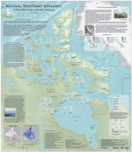
Measuring Tree Canopy Cover in an Urban Environment
To properly and effectively design and manage the city’s tree canopy it is important to quantify the amount and composition…
Out of Place — An Introduction
I know things that others don’t, I feel things that others can’t And yet its not part of this time…
Amy Barker – G.I.S. Officer for the Government of the Northwest Territories
Amy Barker has been working for the Government of the Northwest Territories for over 2 years as a G.I.S. Officer.…
Jean-François Dionne – Senior Geomatics Specialist at WESA Group Inc in Ottawa
The first GoGeomatics Canada interview for February is with Jean-François Dionne. He is the Senior Geomatics Specialist at WESA Group…
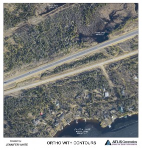
Photogrammetry and Cartographic Specialist
GoGeomatics met with Jenn White a photogrammetry and cartographic specialist to talk about her job hunt and her career. Jenn has worked has worked for the federal government in Ottawa and for industry in the prairies.
Jenn attended the University of Manitoba, where she got a B.A. Advanced with a Major in Geography. In her second year of studies, she took a cartography course and it was from that course, that she became passionate about working with and creating maps. Find out more about Jenn White, a Photogrammetry and Cartographic specialist.
Topcon Experienced Canadian Surveyor
We had the opportunity to talk with Mike Strutt about surveying and his career. Mike is one of the most experienced surveyors in Canada . began his survey career in 1974 and managed his first GPS project in 1987 while a field officer with the Geodetic Survey of Canada. Prior to joining Topcon where he now manages RTN Services, Support & Training, Mike spent in excess of 11 years and 10,000 hours delivering instruction on the use of GPS for surveying and mapping.
If you’re thinking about getting into surveying or just more about what a surveyor does this is a must read.
