
OSGeo

All the Geomatics Acronyms You Wanted to Know but were Too Afraid to Ask
Here in Canada, there are many geomatics acronyms that get tossed around. During the recent “Team Canada” event that the…
OSGEO Presents “Geo for All” Initiative – May 30 Ottawa Social
The GoGeomatics Ottawa May Social is taking place May 30, and we’re pleased to announce that this month’s speaker will…

Ottawa’s Geospatial Leaders Gather for CGCRT Debate at GoGeomatics Social
GoGeomatics Canada was privileged to play host to Ottawa’s geospatial leaders on Friday night. (If you missed it, you’ll be…
An Evening with NRCan & GeoConnections: Ottawa GoGeomatics Social April 25th
Corrina Vester, Canadian Geo-Secretariat Coordinator at National Resource Canada, and Ann Martin, the Director of National Resource Canada’s GeoConnections* program,…
Free Open Source QGIS Seminar in Ottawa April 5th
GoGeomatics Canada is presenting a free day-long seminar for QGIS in Ottawa April 5th at the Sunnyside library. QGIS is…
2014 Canadian Geomatics Events & Conferences
This is our list of Canadian geomatics conferences and events for 2014. Here you will find events pertaining to GIS,…
Open Source Geomatics Software & Geomatics Careers
GoGeomatics had a chance to talk with Teresa Baldwin the Community Manager for FOSSLC, an open source based, not-for-profit group.
Top 10 Canadian Geomatics Twitter Feeds
We have scoured the net and reviewed a number of Canadian Twitter streams. Skilled tweeters can pack a good deal of pertinent information and keen insight into 140 characters. The trouble is, they can be hard to find in a swelling sea of self-aggrandizing micro bloggers. That’s why we have assembled a list of the top ten Twitter feeds from Canadian geomatics professionals, personalities, and organizations.
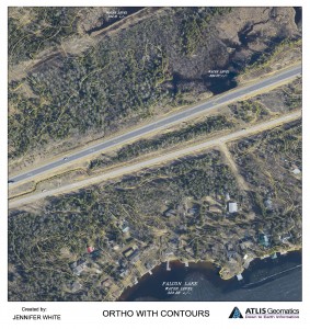
Photogrammetry and Cartographic Specialist
GoGeomatics met with Jenn White a photogrammetry and cartographic specialist to talk about her job hunt and her career. Jenn has worked has worked for the federal government in Ottawa and for industry in the prairies.
Jenn attended the University of Manitoba, where she got a B.A. Advanced with a Major in Geography. In her second year of studies, she took a cartography course and it was from that course, that she became passionate about working with and creating maps. Find out more about Jenn White, a Photogrammetry and Cartographic specialist.
