
OGC Discusses The 2021 Disaster Pilot And What’s To Come
Plans To Improve Disaster Decision Making By Developing Standards-Based Services Open Geospatial Consortium (OGC) Senior Director, Trevor Taylor, spoke regarding…
CCA Ottawa Conference: “150 Years of Cartography: Past, Present and Future”
The 42nd Annual Conference of the Canadian Cartographic Association “150 Years of Cartography: Past, Present and Future” Location: Carleton University,…
Nominations for GIS Science Award: GIScience Study Group CAG – ACG
GIScience Excellence Award Offered and adjudicated by the GIScience Study Group Annual nominations are due by midnight of 15 April…
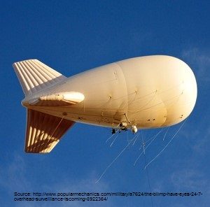
Geospatial Earth Observation Using Blimps, Balloons and Kites
These days drones are all the rage. Nevertheless, there are other ways to collect data from the sky! Blimps, balloons and kites…

Marine Geomatics Primer: Using UUVs to Take Flight Underwater
Unmanned Underwater Vehicles One of the most interesting things to happen in regards to marine geomatics technology has been the…

Feb 7-8: Two Day Workshop on High Resolution Mapping Along Coastal Zones
The coastal zone, that dynamic geographic region where the interaction of the sea and land occurs, is vital to the…

A List of Geospatial Open Data Resources in Canada
Recently, I read an article about the Canadian Geospatial Data Infrastructure (CGDI) that seeks to explain why the CGDI, among many…

Geospatial Development: Enhancing GIS curricula with programming skills at UNB
Geospatial information science and technology (GIS&T) has rapidly evolved over the last few decades. This evolution has created a highly…
Fall Reading in Canada: landscape, language, geography
Last week, I picked up a copy of Robert MacFarlane’s ‘Landmarks’. I had read all of his previous works and…

Become a BCIT GIS Student Project / Practicum Sponsor
The BCIT GIS department has been graduating students for 25+ years. Our students come from BC, but as well, across…

CIG Advancements in Geomatics 2016 Conference in New Brunswick Sept 26th-28th
Advancements in Geomatics – Research and Collaboration for Informed Decisions in a Changing World The Canadian Institute of Geomatics (CIG)…

Esri Technical Associate Certification: how I passed the test
A few months ago, I decided to obtain the Esri Associate certification for ArcGIS Desktop and wrote about my reasoning here. …
