
points

One of the Best Geomatics events in Canada: GeoAlberta 2017
I had a chance to attend the 2017 GeoAlberta conference earlier this month in Calgary, Alberta. This was my first…

UAV Surveys – How to Ensure Accuracy and Precision
For the past four years, I’ve been involved with the capture and delivery of data derived from drones. My experience…
QGIS: Performing Viewshed Analysis on Archaeological Sites
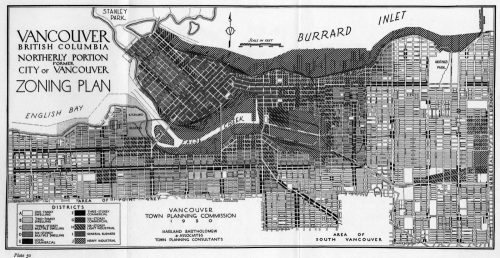
In 1927 a Vancouver bylaw was enacted that limited the height of buildings to a maximum of six stories in…

GIS in Action: How Does BC Pinot Noir Express Terroir?
Editors note: In this previously published article, Karl Kliparchuk, BCIT GIS Program Head & Instructor uses GIS to explore the…

Graph Databases – Recent development in Neo4j may help accommodate the Geospatial Community
Graph Databases and GIS & Technology (GIS&T) In the era of big data, graph databases are becoming very popular as…
Canadian Geomatics Innovation: Ecere Develops a Next Generation GIS
Not many companies undertake the ambitious goal of creating a new geospatial software suite from scratch. Ecere, a Canadian company…
Contrasting: GIS & Geomatics Education in Canada and China
I have studied Geographic Information Systems (GIS) in both Canada and China. Last summer I completed my master in geography at…

The Art of Being a Cadastral Surveyor: Key abilities every surveyor needs
The Art of Being a Cadastral Surveyor: The key abilities every surveyor needs There is an art to being a…

New Brunswick: CARIS Announces release of HIPS and SIPS™ 10
Fredericton, NB, Canada – November 01, 2016 – Teledyne CARIS™ is pleased to announce the release of HIPS and SIPS™ 10.…
NB 911 Bureau Receives Esri Canada Award of Excellence in GIS
FREDERICTON, Esri Canada User Conference – October 25, 2016 – Esri Canada today presented the NB 911 Bureau, a branch…

Canadian Surveyors “Remark” on History with Elk Pass Boundary Restoration Survey
The Alberta-British Columbia Boundary Commission has just completed a monument restoration survey to restore a number of deteriorated provincial boundary…

Earth Observation Represents a $43 Billion Opportunity Over Next 10 Years
NSR’s Satellite-Based Earth Observation (EO), 8th Edition report, released yesterday, projects data, value-added services, information products, and big data analytics…
