
power
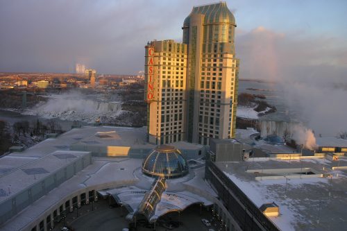
Altus Geomatics’ Contributions to Fallsview Construction Helped to Create World-Class Canadian Casino
When construction began on Niagara Fallsview Casino Resort in 2001, the spectacular natural surroundings belied a particularly difficult problem for…
NB 911 Bureau Receives Esri Canada Award of Excellence in GIS
FREDERICTON, Esri Canada User Conference – October 25, 2016 – Esri Canada today presented the NB 911 Bureau, a branch…

Literary Peregrinations: Geographers as Explorers
While I was reading Andrea Wulf’s “The Invention of Nature. Alexander von Humboldt’s New World”. I noted a comment on…
Montreal: SimActive Offers Free Trial of UAV Software
Montreal, Canada, October 11th, 2016 – SimActive Inc., a world-leading developer of photogrammetry software, is pleased to announce a new…

DigitalGlobe’s Basemap Suite Expands: 250 Million Square Kilometers of 30 cm Imagery
DigitalGlobe, Inc. (NYSE: DGI), the global leader in Earth imagery and information about our changing planet, today announced that its…

UAVs in Canada – Key Exposures to Loss and Ways to Protect Yourself
This article was written by Mark Sampson for the Association of Ontario Land Surveyors. Mark’s contact details are at the…

Advancing Canadian Geographic Education: What Ever Happened to the St. John’s Declaration?
Four years ago, the Atlantic Division of the Canadian Association of Geographers (ACAG) meeting at St. Mary’s University brought a number…

URISA Heads to Toronto for GIS-Pro 2016
The Urban and Regional Information Systems Association (URISA), in partnership with its Ontario, Alberta and British Columbia Chapters, is pleased…

Earth Observation Represents a $43 Billion Opportunity Over Next 10 Years
NSR’s Satellite-Based Earth Observation (EO), 8th Edition report, released yesterday, projects data, value-added services, information products, and big data analytics…

LiDAR in Canada: Conversation with Dr. Chris Hopkinson Research Chair Remote Sensing University of Lethbridge
The author Bob Maher (BM) and Chris Hopkinson (CH) both worked as scientists at the Appied Geomatics Reearch Group (AGRG)…
Airobotics Selects SimActive’s Photogrammetry Software for its Automated Industrial Drone Solution
Montreal, Canada, August 30th, 2016 – SimActive Inc., a world-leading developer of photogrammetry software, is pleased to announce that Airobotics…
Using Colour Transparency to Map Election Results
As the 2016 United States presidential election careens towards its conclusion in November, GIS plays a prominent role in both planning…
