
program

GIS in Action: How Does BC Pinot Noir Express Terroir?
Editors note: In this previously published article, Karl Kliparchuk, BCIT GIS Program Head & Instructor uses GIS to explore the…
Canadian Remote Sensing Training: Summer School – Montreal 19 June 2017
The Earth Observation (EO) Summit 2017 brings together in one exceptional event the 38th Canadian Symposium on Remote Sensing (CSRS),…

Top Ten Climate Change Maps and GIS Applications
Awareness for climate change has been steadily increasing ever since the Green Revolution in the 1960s. There is a plethora…
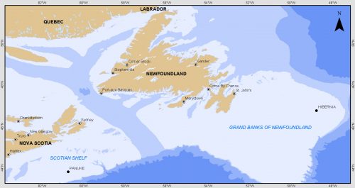
Grand Banks to the Gulf of Mexico: My Canadian Geomatics Career
I often contemplate what it would have been like working at the same job for an entire career. Mind you,…

GNOSIS – A New Geomatics Software Suite
Creating a new GIS from scratch is a tough undertaking. It involves a lot of innovation. Ecere, a Canadian company…
Esri Canada Community Maps Program: Why more communities need to take advantage of this
The Community Maps Program (CMP) was introduced by Esri Canada in 2009 allowing organizations to share and host geographic data. …
TECTERRA Board Names Jonathan Neufeld as Next CEO
February 14, 2017 (Calgary, Alberta) – TECTERRA announced the appointment of Mr. Jonathan Neufeld as the Chief Executive Officer. Neufeld…

Event Recap: COGS & CIG & GANS Cooperate for Mapping Workshop
The Canadian Institute of Geomatics (CIG) Nova Scotia Branch and the Geomatics Association of Nova Scotia (GANS), two regional professional organizations that foster the application of geographic information within the geomatics sector recently collaborated to host a high resolution mapping workshop at the Centre of Geographic Sciences (COGS) in Lawrencetown, Nova Scotia.

UBC Unveils New Masters of Geomatics for Environmental Management
The UBC Faculty of Forestry is excited to announce that the official approval of the Master of Geomatics for Environmental Management…

Vancouver Geospatial Career Seminar February 23rd
GoGeomatics Canada is bringing our popular career seminar to Vancouver this February. This is only the second time we have…

Interview with Sam Scovill, GIS Technician and 3 Day Champion on Jeopardy
Every weeknight, my mom and I watch Jeopardy together. Jeopardy always starts with the announcement of the contestants by their…

Software Development – The Key to Ecere’s Success
It is rare to learn of a GIS company in which much R&D is done up front to create the…
