
Regie

Learn about UAVs at the Ottawa June Social
This is the last month for GoGeomatics Socials before we break for the summer, and in Ottawa we’re going out…

Ottawa’s Geospatial Leaders Gather for CGCRT Debate at GoGeomatics Social
GoGeomatics Canada was privileged to play host to Ottawa’s geospatial leaders on Friday night. (If you missed it, you’ll be…
Discussing the Proposed Pan-Canadian Geomatics Strategy at the University of Ottawa
On April 19th, the Canadian Remote Sensing Society (CRSS) and GoGeomatics Canada got together with other members of the Ottawa…
Giving Thanks to Our Job/Event Posters, Sponsors and Article Contributors
GoGeomatics Canada would like to thank the following contributors, sponsors and companies/organizations for their support since the relaunch of our new…
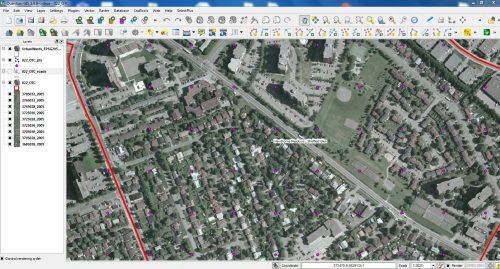
Why Free Open Source Software?
The Free and Open Source Software (FOSS) model provides interacting tools, plugs ins and processes with which Geospatial Analyst (GA)…
Geomatics Impromptu Interviews Part I
During our GoGeomatics Canada website launch party in Ottawa, we encouraged our guests to have a chat about geomatics. Here,…
The Ottawa Tree Canopy Cover Mapping Project
The City of Ottawa Official Plan set a target of 30% tree canopy cover for the entire city. To the…
