
report
Darin Brooks: GIS Instructor, College of the North Atlantic
GoGeomatics: Welcome to the GoGeomatics Canada community. To get started can you tell us about where you are from and…
Lawrie Keillor-Faulkner: GIS Instructor, Fleming College
GoGeomatics Canada is talking to Lawrie Keillor-Faulkner a member of the GIS Faculty at Fleming College in Ontario. GoGeomatics: Welcome…
Thinking Canadian: What is the Power of GIS?
What is the power of GIS? What we have to do is separate GIS from software…

Timothy Ensom – Environmental Scientist
This time around GoGeomatics Canada is looking to the west to find Hydrologist Timothy Ensom at Golder Associates. Welcome to…

Jessica Coleby – Research Analyst at InterStratics Consultants Inc.
GoGeomatics Canada had the privilege of interviewing Jessica Coleby, a Research Analyst at InterStractics. GoGeomatics: Tell us a little…
Stephanie Murphy – GIS Analyst for the R.C.M.P
GoGeomatics Canada would like to welcome one of their editors, Stephanie Murphy. Stephanie graduated from Ryerson University with a Master…
Anne Krahnen – Cartographer and GIS Specialist
GoGeomatics Canada recently had the pleasure of interviewing Anne Krahnen! Anne is a Cartography and Geomatics specialist and is currently…

Wendy Innes: Survey Crew Chief / Geomatics Technician
We would like to introduce Wendy Innes, a graduate of Marine Geomatics program at COGS to help better explain and…
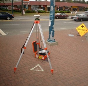
43 Degrees North – Surveying and Mapping Solutions
GoGeomatics is continuing the exploration of careers in surveying by interviewing Thomas Hoppe, the founder of 43 Degrees North – Surveying and Mapping Solutions. 43 Degrees North is situated in Cobourg Ontario in picturesque Northumberland County along the north shore of Lake Ontario is a professional Land Surveying and Geomatics company in Ontario Canada. They provide a variety of geo-referenced solutions from boundary surveys, aerial photography ground support, pre-engineering surveys, construction layout, and survey training with an emphasis on GPS applications and technology
GIS Team Leader
Pat has worked in both the public and private GIS sectors and we were fortunate to have him share his experiences with us. He is currently the GIS Team Leader for all projects that require GIS services.
The office that he works at is involved in Environmental Management, and there are approximately 50 on-going projects. The work environment and turnaround times are usually very fast pace and it is his duty to make sure that the GIS services are delivered with the best quality possible and on time.
Survey Crew Chief / Geomatics Technician
We would like to introduce Wendy Innes, a graduate of Marine Geomatics program at COGS to help better explain and define what a Survey Crew Chief role could be.
