
Standards

OGC Presents Integrating and Sharing Underground Information with MUDDI: SUMSF 2023
On May 16, 2023, during SUMSF 2023, Joshua Lieberman, Director of Innovation Programs at the Open Geospatial Consortium (OGC) presented…

NRCan is the inaugural recipient of the OGC Community Impact Award
New award recognizes OGC members who, through exceptional leadership, volunteerism, collaboration, and investment, have positively impacted the geospatial community. The…

Canadian BIM & Digital Twin Digest Nov 3
Less Jargon, More Standardization Needed In BIM The use of BIM (Business Information Modelling) is increasing in use for different…

The ACLS Wants You: Geodetic Datum Dependencies Survey
The Association of Canada Lands Surveyors (ACLS) invites you to participate in the Geodetic Datum Dependencies Survey. It is a…
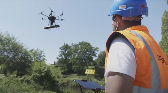
Skipper NDT Uses Drone to Make Pipeline Maintenance Quicker, Safer, and More Precise
The drone-based platform covers the blind spot in current technology. Skipper NDT Co-founder and COO, Luigi Kassir, spoke on locating…
LiDAR News Weighs in on HD Map Standards and the Creation of Opportunities
LiDAR 2022 held a live stream presentation on April 5, 2022, with LiDAR News CEO, Gene Roe. Roe spoke on…
Two New Standards for Utility Infrastructure Data Introduced At SUMSF
With one million strikes in the USA, it works out to one strike a minute during a 10 hour work…

Big Data Geospatial Imagery – Next Level Technology, Platforms, Access, Algorithms, Standards & Skills
Track Chair: James Ashton and John Roos “Everyone agrees with the zero download model. No downloads. We hope that the space agencies will…

UAV Surveys – How to Ensure Accuracy and Precision
For the past four years, I’ve been involved with the capture and delivery of data derived from drones. My experience…
Association of Canada Lands Surveyors Develops New Canadian Hydrographer Certification
Canadian Hydrographer Certification Scheme Association of Canada Lands Surveyors The Association of Canada Lands Surveyors (ACLS) has developed a certification…
The Open Geospatial Consortium (OGC): proposed GeoRSS Community Standard
The Open Geospatial Consortium (OGC®) is requesting public comment on the proposed GeoRSS Community Standard. First available in 2006, GeoRSS…

My COGS GIS Education, Part II
In my first article, I introduced the how and why I chose to attend COGS from the fall of 2014…
