
Tech/Projects
ReForest London: Exciting use of GIS for Community Health & Non-Profits in Canada
Last year I volunteered as a GIS Specialist with ReForest London during the planting season. I am a recent graduate from…

May 16: Thunder Bay GoGeomatics Speaker: Rob Rempel – Research Scientist MNRF
You are cordially invited to our fun free event geomatics networking event on May 16th. Tuesday, May 16, 2017 –…

Mystery Speaker Revealed for Next Ottawa GoGeomatics Social April 25th
GoGeomatics has swept aside the curtain to reveal Masroor Hussain, Senior Scientist and Software Developer at PCI Geomatics, as the…

Google Earth Engine – What is a Data Cube and Why Canadians Should Care
What is a data cube and how is it used for big data analytics? How does a data cube work…
QGIS: Performing Viewshed Analysis on Archaeological Sites
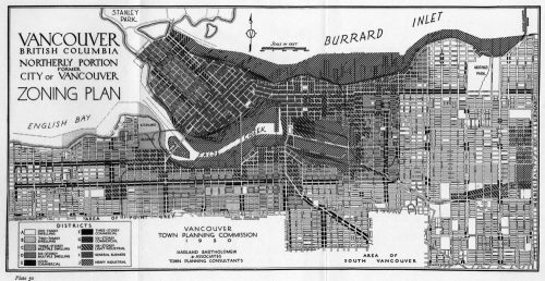
In 1927 a Vancouver bylaw was enacted that limited the height of buildings to a maximum of six stories in…

GIS in Action: How Does BC Pinot Noir Express Terroir?
Editors note: In this previously published article, Karl Kliparchuk, BCIT GIS Program Head & Instructor uses GIS to explore the…

Software Development – The Key to Ecere’s Success
It is rare to learn of a GIS company in which much R&D is done up front to create the…

GIS in Public Health: Kingston GoGeomatics Social Thursday, January 19
Free GIS & Public Health Talk in Kingston Thursday, January 19, 2017 6:00 PM Sir John A Public House 343…

List of Canadian Geomatics Conferences and Events for 2017
This is our list Canadian geomatics conferences and events for 2017. Here you will find events pertaining to GIS, remote…
Exploring GIS Day at the Glenbow Museum, Calgary.
I had the opportunity to celebrate GIS Day by attending the event hosted by the Alberta Geomatics Group at the…

Ten Online GIS Programs in Canada
After completing an undergraduate degree in 2015, (Geography and Environmental Studies at the University of Toronto) I needed to determine…

QGIS & WorldClim: Using Zonal Statistics to Map Temperature Patterns
There has never been a time in the history of GIS when so much free, high quality data has been…
