
Toronto

2022 Back to School Socials in Pictures – Thank you Sponsors & Participants!
The 7th annual GoGeomatics 2022 Back to School Socials have been a tremendous success. Our groups and group leaders across…

XXV ISPRS Congress in Toronto in 2026
At the XXIV Congress in Nice, France, the ISPRS General Assembly elected Canada to host the XXV ISPRS Congress in…

Accuracy and Precision [Part II]: Identify GIS Data Inconsistency: Examples From Toronto’s Open Data Portal
This article is the second part of the accuracy and precision series, which discusses data characteristics, examples of data inconsistency…
Canadian Geospatial Briefing Sept 20th: Interactive Election Map; MDA awarded with contract for Martian Moons Exploration with Japan Aerospace Exploration Agency; Geomatics Instructor at BCIT uses Drone to Display Elevation Changes at Construction Site; Looking at Foot Traffic in the Downtown Core of Major Canadian Cities Compared to Pre-Pandemic Levels; Apple Maps using Special Backpacks to Gather Data for Look Around Feature
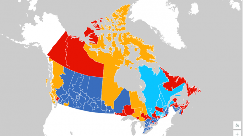
Interactive: How Canadians voted in the past 7 federal elections With the federal elections coming up on September 20th, Esri…

GoodScore.City: Comparing the Environmental Health of Canada’s Downtown Cores
The Canadian Urban Environmental Health Research Consortium (CANUE) is a group dedicated to understanding urban living and its impacts on…
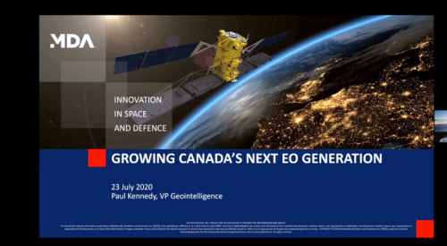
GeoIgnite 2020: Growing Canada’s Next Earth Observation (EO) Generation
GeoIgnite is Canada’s National Geospatial conference hosted by GoGeomatics Canada. GeoIgnite was held online using Zoom July 22nd to 24th,…
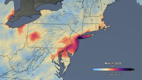
Mapping air pollution: a momentary shift due to COVID-19
COVID-19 and the resulting economic shutdowns and physical distancing measures have presented us with a peek at what it takes…

GoGeomatics Toronto and Vancouver Career Event Update – COVID-19
The health and wellness of our community deserves our utmost care and attention. GoGeomatics Canada continues to monitor the global health situation Coronavirus/COVID-19 and has…
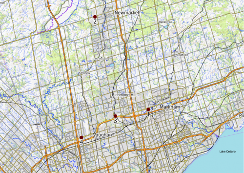
Using GIS to Track Land Use Change in York Region – Urban Growth Centres
Our last article examined the use of GIS technology to track land use change in four Toronto districts. Each district represented an…

REGISTRATION OPEN: CANADIAN GEOSPATIAL RECRUITING EVENTS
Based on the incredible success of our Future of Geospatial Careers Event last June, GoGeomatics is bringing this format to…

Your Canadian Geospatial Briefing for December 9th: 15 Teams Sign Up for 2020 UAS Competition; GeoIgnite 2020; Planit Measuring – New Ways to Build Digital Twins; Google’s “Smart City” in Toronto
15 Teams Sign Up for 2020 UAS Competition From May 1-3 2020, Southport Manitoba will host 15 university teams for…
Your Canadian Geospatial Briefing for November 25th: Mapping Toronto’s Most Bizarre Intersections; Canada’s 5G Network: USA issues warning; GeoVangelist Wins the 2019 Alex Trebek Medal for Geographic Literacy; Mapping Canada’s Hidden Treasure
Mapping Toronto’s Most Bizarre Intersections For most people from Toronto, when they think of what their city is known for,…
